TopoQuest Logo
Do you find TopoQuest useful?
Help keep TopoQuest running and adding new maps/features by donating!
Bitcoin:  19c7KJd3qBynnjoSw5npx9KScwjBe4ifkT
Litecoin:  LXs6TkuXGGXo1vDsWCkWVdjQX94eUKd6ui
Home View Maps Find Maps Find Places Resources & Links


Glade Spring, Virginia Topographic Map

USGS Map Title: Glade Spring, VA
USGS Map MRC: 36081G7
DRG (GeoTIFF) Download: o36081g7.tif


Neighboring USGS Topographic Map Quads:


  Elk Garden, VA  
36081H8
 

  Saltville, VA  
36081H7
 

  Broadford, VA  
36081H6
 

  Hayters Gap, VA  
36081G8
 

  Glade Spring, VA  
36081G7
 

  Chilhowie, VA  
36081G6
 

  Abingdon, VA  
36081F8
 

  Damascus, VA  
36081F7
 

  Konnarock, VA  
36081F6


Map MRC Location:

N37°
W82°
N37°
W81°
H8 H7 H6 H5 H4 H3 H2 H1
G8 G7 G6 G5 G4 G3 G2 G1
F8 F7 F6 F5 F4 F3 F2 F1
E8 E7 E6 E5 E4 E3 E2 E1
D8 D7 D6 D5 D4 D3 D2 D1
C8 C7 C6 C5 C4 C3 C2 C1
B8 B7 B6 B5 B4 B3 B2 B1
A8 A7 A6 A5 A4 A3 A2 A1
N36°
W82°
N36°
W81°

Glade Spring, VA USGS 1:24K Topographic Map Preview:
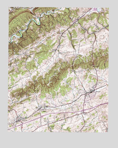
Glade Spring, VA USGS Topographic Map
Click on map above to begin viewing in our Map Viewer.

This topographic map contains these locations and features:
Feature Name Type Latitude Longitude GNIS ID View Map
Bald KnobSummitN36.8034°W81.8343°1494819View Map
Baptist CemeteryCemeteryN36.7921°W81.7865°1481448View Map
Big CreekStreamN36.8387°W81.8715°1481718View Map
BlacksburgPopulated PlaceN36.7543°W81.8204°1494842View Map
BlackwellPopulated PlaceN36.8287°W81.8565°1488795View Map
Blackwell BranchStreamN36.8265°W81.8662°1481841View Map
Blackwell CemeteryCemeteryN36.8283°W81.8535°2774746View Map
Broady CemeteryCemeteryN36.8382°W81.8398°1482022View Map
Byars Hall Visual and Performing Arts CenterBuildingN36.7733°W81.8300°2101924View Map
Carriger and Matthews HallsBuildingN36.7731°W81.8308°2101925View Map
ClarksvillePopulated PlaceN36.7987°W81.7651°1494877View Map
ClinchburgPopulated PlaceN36.8321°W81.8146°1494882View Map
Collins HollowValleyN36.8225°W81.8053°1482655View Map
Collins HouseBuildingN36.7731°W81.8342°2101926View Map
Count BranchStreamN36.8718°W81.8454°1482721View Map
DeVault FieldParkN36.7744°W81.8258°2101927View Map
Double Spring BranchStreamN36.8265°W81.8660°1483073View Map
East Fork Hall CreekStreamN36.7729°W81.8032°1483208View Map
Emily Williams HouseBuildingN36.7744°W81.8322°2101928View Map
EmoryPopulated PlaceN36.7729°W81.8362°1483301View Map
Emory and Henry CemeteryCemeteryN36.7776°W81.8310°1498254View Map
Emory and Henry CollegeSchoolN36.7721°W81.8330°1483302View Map
Emory Census Designated PlaceCensusN36.7800°W81.8280°2584842View Map
Emory Merchantile Company BuildingBuildingN36.7753°W81.8292°2101929View Map
Emory Post OfficePost OfficeN36.7756°W81.8279°2766359View Map
Emory-Meadow View Census Designated Place (historical)CensusN36.7717°W81.8515°2389043View Map
Fullerton FieldParkN36.7733°W81.8281°2101930View Map
Glade SpringPopulated PlaceN36.7912°W81.7712°1483656View Map
Glade Spring Middle SchoolSchoolN36.7774°W81.7791°1498261View Map
Glade Spring Police DepartmentBuildingN36.7897°W81.7714°2085857View Map
Glade Spring Post OfficePost OfficeN36.7904°W81.7699°2780808View Map
Glade Spring Volunteer Fire DepartmentBuildingN36.7917°W81.7681°2721047View Map
Glade Spring Volunteer Life Saving CrewBuildingN36.7915°W81.7673°2721092View Map
Gosby CemeteryCemeteryN36.7782°W81.8704°1483713View Map
GreenfieldLocaleN36.8298°W81.8101°1494970View Map
Hall KnobSummitN36.8159°W81.8460°1494979View Map
HanckelPopulated PlaceN36.8496°W81.8057°1494981View Map
Hanger HollowValleyN36.8132°W81.7527°1483923View Map
Hardscrabble HollowValleyN36.8550°W81.7541°1483935View Map
Hebron CemeteryCemeteryN36.8412°W81.7684°1498274View Map
Hebron ChurchChurchN36.8409°W81.7685°1484013View Map
HendersonPopulated PlaceN36.8743°W81.8565°1494988View Map
Interchange 24CrossingN36.7576°W81.8573°1498287View Map
Interchange 26CrossingN36.7651°W81.8337°1498288View Map
Interchange 29CrossingN36.7718°W81.7810°1498289View Map
J Stewart French Alumni HouseBuildingN36.7747°W81.8303°2101932View Map
Jackson SchoolSchoolN36.8715°W81.8204°1484391View Map
Kelly LibraryBuildingN36.7736°W81.8314°2101933View Map
Kelly RidgeRidgeN36.8143°W81.8165°1484541View Map
KeywoodPopulated PlaceN36.8248°W81.7907°1495015View Map
Keywood BranchStreamN36.8596°W81.7932°1484579View Map
Keywood HollowValleyN36.8578°W81.8357°1484580View Map
King Health and Physical Education CenterBuildingN36.7742°W81.8272°2101934View Map
Liberty Hill SchoolSchoolN36.8490°W81.8079°1484798View Map
LitzPopulated PlaceN36.8118°W81.7921°1495042View Map
Martin - Brock Student CenterBuildingN36.7728°W81.8292°2101935View Map
McCall GapGapN36.8159°W81.7682°1485254View Map
McCall GapPopulated PlaceN36.8112°W81.7654°1495056View Map
McCalls Gap Presbyterian ChurchChurchN36.8126°W81.7662°1498307View Map
McGlothlin - Street HallBuildingN36.7722°W81.8328°2101936View Map
McHenry CreekStreamN36.8748°W81.8012°1470264View Map
McNew CemeteryCemeteryN36.8187°W81.8179°1485317View Map
Meadow View Census Designated PlaceCensusN36.7638°W81.8727°2584879View Map
MeadowviewPopulated PlaceN36.7604°W81.8629°1502802View Map
Meadowview Elementary SchoolSchoolN36.7514°W81.8586°1498311View Map
Meadowview Post OfficePost OfficeN36.7621°W81.8613°2780810View Map
Meadowview Volunteer Fire DepartmentBuildingN36.7618°W81.8604°2721044View Map
Miller - Fulton HallBuildingN36.7719°W81.8328°2101938View Map
Monroe DistrictCivilN36.7671°W81.8051°1927410View Map
Moore BranchStreamN36.8282°W81.8568°1485532View Map
Moore CemeteryCemeteryN36.8148°W81.8704°1485537View Map
Morris SchoolSchoolN36.7557°W81.7785°1485559View Map
Muddy HollowValleyN36.8694°W81.8128°1485741View Map
Old Glade SpringPopulated PlaceN36.7693°W81.7807°1495080View Map
Old Glade Spring CemeteryCemeteryN36.7673°W81.7871°1498318View Map
Patrick Henry High SchoolSchoolN36.7763°W81.8148°1498321View Map
Patrick HollowValleyN36.8511°W81.8544°1486081View Map
PlastercoPopulated PlaceN36.8607°W81.7907°1495093View Map
Plasterco Post Office (historical)Post OfficeN36.8621°W81.7890°1499033View Map
President's House - Emory and Henry CollegeBuildingN36.7719°W81.8347°2101939View Map
Price BridgeBridgeN36.7529°W81.7501°1486424View Map
Price HillPopulated PlaceN36.7604°W81.7562°1495099View Map
Richardson BranchStreamN36.7737°W81.8037°1486595View Map
Scarbrough HouseBuildingN36.7728°W81.8308°2101940View Map
Seven Springs ChurchChurchN36.8104°W81.7904°1487005View Map
Smyth ChapelChurchN36.7823°W81.8435°1487354View Map
Smyth GapGapN36.7909°W81.8421°1487355View Map
Snodgrass CemeteryCemeteryN36.8426°W81.8723°1487373View Map
South Fork McHenry CreekStreamN36.8498°W81.7682°1487402View Map
Stonemill CreekStreamN36.8687°W81.8262°1487606View Map
Studio TheatreBuildingN36.7736°W81.8292°2101943View Map
Sullins HallBuildingN36.7722°W81.8306°2101944View Map
The DepotBuildingN36.7753°W81.8283°2101945View Map
Thomas CemeteryCemeteryN36.8187°W81.8646°1487863View Map
Tobias Smyth HouseBuildingN36.7722°W81.8311°2101947View Map
Town of Glade SpringCivilN36.7900°W81.7725°2390205View Map
Tumbling CreekPopulated PlaceN36.8743°W81.8460°1495154View Map
Tumbling CreekStreamN36.8632°W81.8373°1488009View Map
Tumbling Creek CemeteryCemeteryN36.8746°W81.8457°1498345View Map
Union ChurchChurchN36.8609°W81.7896°1498347View Map
Union ChurchChurchN36.8718°W81.7762°1500557View Map
Van Dyke CenterBuildingN36.7739°W81.8289°2101948View Map
Weaver HallBuildingN36.7758°W81.8267°2101949View Map
Wiley Jackson HallBuildingN36.7733°W81.8333°2101951View Map
Woodward Cove BranchStreamN36.8712°W81.8718°1488485View Map
Worley CemeteryCemeteryN36.8440°W81.8671°1488487View Map
Zion Methodist Episcopal ChurchChurchN36.8651°W81.7843°1498376View Map

Note: Coordinates in the location and feature list above are referenced to NAD83 datum.


Copyright (C) 2008-2024 Ryan Niemi / Sunset Dynamics ... All Rights Reserved