TopoQuest Logo
Do you find TopoQuest useful?
Help keep TopoQuest running and adding new maps/features by donating!
Bitcoin:  19c7KJd3qBynnjoSw5npx9KScwjBe4ifkT
Litecoin:  LXs6TkuXGGXo1vDsWCkWVdjQX94eUKd6ui
Home View Maps Find Maps Find Places Resources & Links


Damascus, Virginia Topographic Map

USGS Map Title: Damascus, VA
USGS Map MRC: 36081F7
DRG (GeoTIFF) Download: o36081f7.tif


Neighboring USGS Topographic Map Quads:


  Hayters Gap, VA  
36081G8
 

  Glade Spring, VA  
36081G7
 

  Chilhowie, VA  
36081G6
 

  Abingdon, VA  
36081F8
 

  Damascus, VA  
36081F7
 

  Konnarock, VA  
36081F6
 

  Shady Valley, TN  
36081E8
 

  Laurel Bloomery, TN  
36081E7
 

  Grayson, NC  
36081E6


Map MRC Location:

N37°
W82°
N37°
W81°
H8 H7 H6 H5 H4 H3 H2 H1
G8 G7 G6 G5 G4 G3 G2 G1
F8 F7 F6 F5 F4 F3 F2 F1
E8 E7 E6 E5 E4 E3 E2 E1
D8 D7 D6 D5 D4 D3 D2 D1
C8 C7 C6 C5 C4 C3 C2 C1
B8 B7 B6 B5 B4 B3 B2 B1
A8 A7 A6 A5 A4 A3 A2 A1
N36°
W82°
N36°
W81°

Damascus, VA USGS 1:24K Topographic Map Preview:
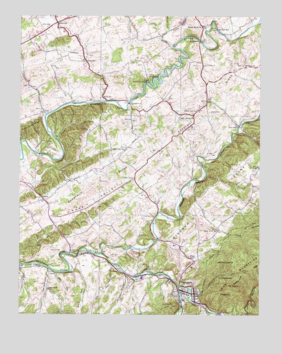
Damascus, VA USGS Topographic Map
Click on map above to begin viewing in our Map Viewer.

This topographic map contains these locations and features:
Feature Name Type Latitude Longitude GNIS ID View Map
Astin CemeteryCemeteryN36.7459°W81.8601°1481352View Map
Bear BranchStreamN36.6357°W81.8598°1481509View Map
Beaverdam CreekStreamN36.6365°W81.7918°1481571View Map
Beech CreekStreamN36.6818°W81.7826°1481589View Map
Beech Grove SchoolSchoolN36.6604°W81.7715°1481593View Map
Buck BridgeBridgeN36.7040°W81.7607°1482107View Map
Bucks BranchStreamN36.7015°W81.7610°1482139View Map
Buzzard Den BranchStreamN36.6801°W81.7640°1482191View Map
Byers CreekStreamN36.7368°W81.7946°1482200View Map
Camp PocahontasLocaleN36.7237°W81.8068°1482269View Map
Cedar BluffPopulated PlaceN36.6357°W81.8598°1492731View Map
Cedar Bluff HollowValleyN36.6436°W81.8589°1488573View Map
Cedar Bluff United Methodist ChurchChurchN36.6357°W81.8601°1498237View Map
Cedar CreekStreamN36.7143°W81.8304°1482399View Map
Chestnut RidgeRidgeN36.6943°W81.8096°1482489View Map
Clark Mountain TrailTrailN36.6554°W81.7690°1482546View Map
Craig BridgeBridgeN36.7398°W81.7810°1482801View Map
DamascusPopulated PlaceN36.6337°W81.7837°1482904View Map
Damascus CemeteryCemeteryN36.6380°W81.7851°1498247View Map
Damascus Fire DepartmentBuildingN36.6351°W81.7905°2721026View Map
Damascus Middle SchoolSchoolN36.6398°W81.8040°1498248View Map
Damascus Post OfficePost OfficeN36.6361°W81.7898°2780806View Map
Damascus Town Police DepartmentBuildingN36.6351°W81.7903°2085856View Map
Damascus Volunteer Rescue SquadBuildingN36.6385°W81.8034°2721140View Map
De Busk MillPopulated PlaceN36.7448°W81.7718°1492845View Map
DeBusk HollowValleyN36.6438°W81.8461°1482956View Map
DelmarPopulated PlaceN36.6429°W81.8593°1488574View Map
Drowning FordPopulated PlaceN36.6515°W81.8410°1492884View Map
East Fork Cedar CreekStreamN36.7487°W81.8568°1483204View Map
Ebbing Spring ChurchChurchN36.7457°W81.7801°1483228View Map
Edmondson DamDamN36.7218°W81.8098°1502371View Map
Edmondson DamDamN36.7223°W81.8090°1502008View Map
Fisher HollowValleyN36.6450°W81.8260°1483425View Map
Gimlet BranchStreamN36.6443°W81.8593°1483642View Map
Grant HollowValleyN36.6423°W81.8547°1483745View Map
GreenfieldPopulated PlaceN36.7315°W81.8410°1493033View Map
Greenway CreekStreamN36.7087°W81.8612°1483827View Map
Groseclose CornerPopulated PlaceN36.6682°W81.8026°1498267View Map
Hall CreekStreamN36.7446°W81.7973°1483903View Map
Henry Widener BranchStreamN36.6837°W81.7773°1484045View Map
High Point Elementary SchoolSchoolN36.6937°W81.8271°1484089View Map
Holston High SchoolSchoolN36.6539°W81.7937°1498281View Map
Honey Locust BranchStreamN36.6982°W81.8726°1484185View Map
Indian RunStreamN36.7407°W81.8010°1484336View Map
Indoor Farms GreenhousesBuildingN36.7378°W81.8681°2677664View Map
Ketchum BranchStreamN36.7084°W81.7504°1484569View Map
Ketron CornerPopulated PlaceN36.6471°W81.7840°1498294View Map
Laurel CreekStreamN36.6504°W81.8323°1484695View Map
Laurel SchoolSchoolN36.6437°W81.8218°1484728View Map
Liberty Hall SchoolSchoolN36.7098°W81.7815°1484795View Map
LodiPopulated PlaceN36.7148°W81.7773°1485029View Map
Luther ChapelChurchN36.6815°W81.8154°1488633View Map
Mast BridgeBridgeN36.6818°W81.7829°1485221View Map
Middle Fork Holston RiverReservoirN36.7218°W81.8098°1491008View Map
Mock MillPopulated PlaceN36.7168°W81.8315°1493300View Map
Moore CemeteryCemeteryN36.7098°W81.7760°1485535View Map
Mount Olivet ChurchChurchN36.7287°W81.7573°1485614View Map
Mount Olivet Church CemeteryCemeteryN36.7283°W81.7575°2774742View Map
NeffPopulated PlaceN36.7104°W81.8626°1485816View Map
New Zion School (historical)SchoolN36.6629°W81.8337°1498315View Map
Oak Hill CemeteryCemeteryN36.6660°W81.8044°1485938View Map
OsceolaPopulated PlaceN36.6732°W81.8626°1486006View Map
Pleasant View ChurchChurchN36.6859°W81.7521°1486299View Map
Ramsey BranchStreamN36.6423°W81.8196°1486498View Map
Rhea ValleyBasinN36.6726°W81.8354°1486574View Map
Rhea Valley Elementary SchoolSchoolN36.6832°W81.8175°1498326View Map
Rock Spring ChurchChurchN36.7082°W81.7846°1486706View Map
Roe CemeteryCemeteryN36.6497°W81.8251°1486757View Map
RoetownPopulated PlaceN36.6432°W81.8273°1493502View Map
Russell BranchStreamN36.6982°W81.8548°1486824View Map
SnodgrassPopulated PlaceN36.7251°W81.8321°1498337View Map
Tattle BranchStreamN36.7407°W81.8010°1487782View Map
Taylor DistrictCivilN36.6742°W81.7664°1927534View Map
The CuckooGapN36.6368°W81.7657°1487820View Map
Town of DamascusCivilN36.6326°W81.7889°2390819View Map
Vails MillPopulated PlaceN36.6401°W81.8110°1493731View Map
VestalPopulated PlaceN36.6529°W81.8485°1498352View Map
West Fork Cedar CreekStreamN36.7493°W81.8654°1488251View Map
Wright BranchStreamN36.6409°W81.7960°1488489View Map
Wright BridgeBridgeN36.6568°W81.8026°1488492View Map
Wright ChapelChurchN36.6493°W81.7862°1487093View Map
Wright HollowValleyN36.6769°W81.7500°1487094View Map
Zion ChurchChurchN36.6573°W81.8496°1487132View Map
Zion Church CemeteryCemeteryN36.6577°W81.8489°2774732View Map

Note: Coordinates in the location and feature list above are referenced to NAD83 datum.


Copyright (C) 2008-2024 Ryan Niemi / Sunset Dynamics ... All Rights Reserved