TopoQuest Logo
Do you find TopoQuest useful?
Help keep TopoQuest running and adding new maps/features by donating!
Bitcoin:  19c7KJd3qBynnjoSw5npx9KScwjBe4ifkT
Litecoin:  LXs6TkuXGGXo1vDsWCkWVdjQX94eUKd6ui
Home View Maps Find Maps Find Places Resources & Links


Gates, North Carolina Topographic Map

USGS Map Title: Gates, NC
USGS Map MRC: 36076E7
DRG (GeoTIFF) Download: o36076e7.tif


Neighboring USGS Topographic Map Quads:


  Franklin, VA  
36076F8
 

  Holland, VA  
36076F7
 

  Buckhorn, VA  
36076F6
 

  Riverdale, VA  
36076E8
 

  Gates, NC  
36076E7
 

  Whaleyville, VA  
36076E6
 

  Winton, NC  
36076D8
 

  Gatesville, NC  
36076D7
 

  Merchants Millpond, NC  
36076D6


Map MRC Location:

N37°
W77°
N37°
W76°
H8 H7 H6 H5 H4 H3 H2 H1
G8 G7 G6 G5 G4 G3 G2 G1
F8 F7 F6 F5 F4 F3 F2 F1
E8 E7 E6 E5 E4 E3 E2 E1
D8 D7 D6 D5 D4 D3 D2 D1
C8 C7 C6 C5 C4 C3 C2 C1
B8 B7 B6 B5 B4 B3 B2 B1
A8 A7 A6 A5 A4 A3 A2 A1
N36°
W77°
N36°
W76°

Gates, NC USGS 1:24K Topographic Map Preview:
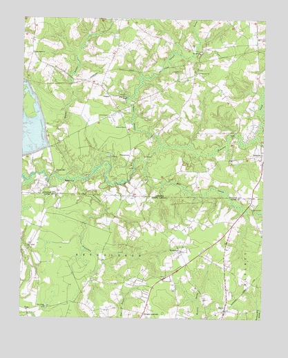
Gates, NC USGS Topographic Map
Click on map above to begin viewing in our Map Viewer.

This topographic map contains these locations and features:
Feature Name Type Latitude Longitude GNIS ID View Map
Beaverdam CreekStreamN36.5565°W76.8477°1025130View Map
Chapel SwampStreamN36.5729°W76.8033°1478363View Map
CleopusPopulated PlaceN36.5929°W76.8300°1494879View Map
Corinth ChapelChurchN36.5843°W76.8302°1478424View Map
DortPopulated PlaceN36.5296°W76.8697°1006179View Map
Factory HillPopulated PlaceN36.5615°W76.8583°1494907View Map
GatesPopulated PlaceN36.5035°W76.7691°985608View Map
Gates Post OfficePost OfficeN36.5037°W76.7690°2774102View Map
Gates Volunteer Fire DepartmentBuildingN36.5030°W76.7710°2638945View Map
Holly Neck School (historical)SchoolN36.6118°W76.7825°1707498View Map
Holy Neck ChurchChurchN36.6107°W76.7830°1478783View Map
Holy Neck PondLakeN36.5921°W76.8207°1478784View Map
House of PrayerChurchN36.5796°W76.8211°1478793View Map
March SwampStreamN36.5588°W76.8508°1479042View Map
Marsh Hill School (historical)SchoolN36.6024°W76.8730°1707507View Map
Marshs Millpond (historical)ReservoirN36.5582°W76.8091°1707508View Map
Mill SwampStreamN36.5646°W76.8113°1502071View Map
Mill SwampStreamN36.5646°W76.8113°1026323View Map
Olive Branch ChurchChurchN36.6104°W76.8691°1479271View Map
PittmantownPopulated PlaceN36.5682°W76.8188°1495092View Map
Pleasant Grove ChurchChurchN36.6024°W76.7841°1479341View Map
Pleasant Hill School (historical)SchoolN36.6015°W76.7863°1707526View Map
Red Oak Grove ChurchChurchN36.5463°W76.7550°993129View Map
ReynoldsonPopulated PlaceN36.5282°W76.7922°1006347View Map
Sandy Hill SchoolSchoolN36.5160°W76.8375°1003370View Map
Savages CrossroadsPopulated PlaceN36.5021°W76.8108°1006365View Map
SomertonPopulated PlaceN36.5682°W76.7513°1495129View Map
Stony Branch ChurchChurchN36.5049°W76.8613°995552View Map
TopsyPopulated PlaceN36.5035°W76.8708°1006391View Map
Township of ReynoldsonCivilN36.5067°W76.8382°1026708View Map

Note: Coordinates in the location and feature list above are referenced to NAD83 datum.


Copyright (C) 2008-2024 Ryan Niemi / Sunset Dynamics ... All Rights Reserved