TopoQuest Logo
Do you find TopoQuest useful?
Help keep TopoQuest running and adding new maps/features by donating!
Bitcoin:  19c7KJd3qBynnjoSw5npx9KScwjBe4ifkT
Litecoin:  LXs6TkuXGGXo1vDsWCkWVdjQX94eUKd6ui
Home View Maps Find Maps Find Places Resources & Links


Gardiner, New York Topographic Map

USGS Map Title: Gardiner, NY
USGS Map MRC: 41074F2
DRG (GeoTIFF) Download: o41074f2.tif


Neighboring USGS Topographic Map Quads:


  Kerhonkson, NY  
41074G3
 

  Mohonk Lake, NY  
41074G2
 

  Rosendale, NY  
41074G1
 

  Napanoch, NY  
41074F3
 

  Gardiner, NY  
41074F2
 

  Clintondale, NY  
41074F1
 

  Pine Bush, NY  
41074E3
 

  Walden, NY  
41074E2
 

  Newburgh, NY  
41074E1


Map MRC Location:

N42°
W75°
N42°
W74°
H8 H7 H6 H5 H4 H3 H2 H1
G8 G7 G6 G5 G4 G3 G2 G1
F8 F7 F6 F5 F4 F3 F2 F1
E8 E7 E6 E5 E4 E3 E2 E1
D8 D7 D6 D5 D4 D3 D2 D1
C8 C7 C6 C5 C4 C3 C2 C1
B8 B7 B6 B5 B4 B3 B2 B1
A8 A7 A6 A5 A4 A3 A2 A1
N41°
W75°
N41°
W74°

Gardiner, NY USGS 1:24K Topographic Map Preview:
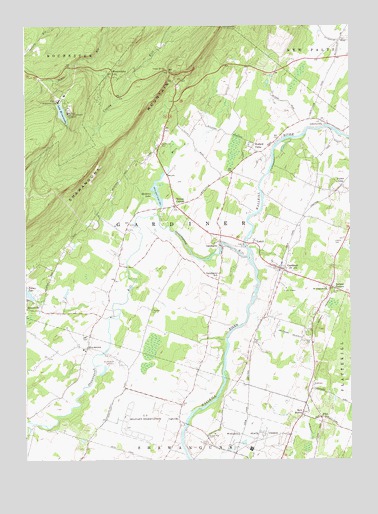
Gardiner, NY USGS Topographic Map
Click on map above to begin viewing in our Map Viewer.

This topographic map contains these locations and features:
Feature Name Type Latitude Longitude GNIS ID View Map
Benton CornersPopulated PlaceN41.6984°W74.1921°943709View Map
Brookside Farm of GardinerLocaleN41.6525°W74.1858°2559335View Map
BruynswickPopulated PlaceN41.6576°W74.2263°972272View Map
Bruynswick Rural CemeteryCemeteryN41.6529°W74.2133°944988View Map
Bruynswick School (historical)SchoolN41.6589°W74.2261°2095850View Map
Deerhaven Mobile Home ParkPopulated PlaceN41.6611°W74.1844°2599356View Map
District School Number 7 (historical)SchoolN41.6989°W74.1903°2095852View Map
Dolan OrchardsLocaleN41.6372°W74.1478°2516172View Map
Dubois CemeteryCemeteryN41.6879°W74.1311°948726View Map
Dwaar KillStreamN41.6262°W74.1882°970089View Map
FlintPopulated PlaceN41.6373°W74.1365°972482View Map
Forest GlenPopulated PlaceN41.7040°W74.1282°972490View Map
Four Winds FarmLocaleN41.6617°W74.1436°2559312View Map
GalevillePopulated PlaceN41.6365°W74.1910°972526View Map
Galeville Airport (historical)AirportN41.6353°W74.2078°2095848View Map
Galeville School (historical)SchoolN41.6375°W74.1917°2095853View Map
Ganahgote SchoolSchoolN41.6776°W74.1768°950869View Map
GardinerPopulated PlaceN41.6798°W74.1504°950882View Map
Gardiner AirportAirportN41.6687°W74.1542°978029View Map
Gardiner Census Designated PlaceCensusN41.6795°W74.1479°2389829View Map
Gardiner LibraryBuildingN41.6790°W74.1522°2599424View Map
Gardiner Post OfficePost OfficeN41.6801°W74.1508°2599243View Map
Gardiner Reformed ChurchChurchN41.6811°W74.1544°2598115View Map
Gardiner Volunteer Fire Department and Ambulance Station 1BuildingN41.6795°W74.1490°2735499View Map
Gardiner Volunteer Fire Department and Ambulance Station 2BuildingN41.7200°W74.1961°2735500View Map
Gertrudes NoseCliffN41.6945°W74.2482°1781935View Map
Heddens LakeReservoirN41.7023°W74.1990°952518View Map
Ireland CornersPopulated PlaceN41.6748°W74.1326°953752View Map
Jenkins And Lueken OrchardLocaleN41.7314°W74.1561°2516178View Map
Journey's End FarmLocaleN41.6689°W74.1886°2559334View Map
Lake MinnewaskaPopulated PlaceN41.7354°W74.2163°957421View Map
Lake MinnewaskaLakeN41.7253°W74.2355°957422View Map
Lake Minnewaska CliffhouseLocaleN41.7254°W74.2324°954927View Map
LibertyvillePopulated PlaceN41.7223°W74.1351°955281View Map
Mara KillStreamN41.6959°W74.1993°956486View Map
Millbrook MountainSummitN41.7084°W74.2260°1781936View Map
Modena Country Club Mobile Home ParkPopulated PlaceN41.6475°W74.1256°2599368View Map
Mulford CemeteryCemeteryN41.6301°W74.1801°958132View Map
New HurleyPopulated PlaceN41.6381°W74.1438°972836View Map
New Hurley CemeteryCemeteryN41.6387°W74.1430°2095849View Map
New Hurley Reformed ChurchChurchN41.6381°W74.1428°2460948View Map
Ontrack Thoroughbred Training CenterLocaleN41.7094°W74.1919°2559331View Map
Orchard Hill NurseryLocaleN41.6269°W74.1375°2559319View Map
Parkers Landing HeliportAirportN41.6545°W74.1399°978030View Map
Phillies Bridge Farm ProjectLocaleN41.6936°W74.1311°2559321View Map
Raindancer FarmLocaleN41.7167°W74.1750°2559333View Map
Rivendell WineryLocaleN41.7142°W74.1611°2559322View Map
Saint Charles Borromeo ChurchChurchN41.6746°W74.1344°963425View Map
Shawangunk Correctional FacilityBuildingN41.6356°W74.1634°2756200View Map
Shawangunk Grasslands National Wildlife RefugeParkN41.6369°W74.2076°2514404View Map
Shawangunk KillStreamN41.6837°W74.1649°964981View Map
Shawangunk MountainsRangeN41.7248°W74.2046°964983View Map
Shawangunk Reformed ChurchChurchN41.6535°W74.2136°2460949View Map
Shawangunk Valley Volunteer Fire Company and AmbulanceBuildingN41.6590°W74.2261°2735459View Map
Thober Mobile Home ParkPopulated PlaceN41.7325°W74.1547°2599379View Map
Tillson LakeLakeN41.6731°W74.2497°967527View Map
Town of GardinerCivilN41.6949°W74.1869°978986View Map
Trapps BridgeBridgeN41.7373°W74.1949°967760View Map
TuthillPopulated PlaceN41.6876°W74.1624°973170View Map
TuthilltownPopulated PlaceN41.6870°W74.1754°950868View Map
Tuthilltown BridgeBridgeN41.6878°W74.1656°2419924View Map
Tuthilltown Grist MillLocaleN41.6859°W74.1718°1782024View Map
Valley Assembly of GodChurchN41.6804°W74.2133°2598139View Map
Wallkill CampPopulated PlaceN41.7162°W74.1621°968703View Map
Wallkill Correctional FacilityBuildingN41.6280°W74.1634°975716View Map
Whitecliff Vineyard And WineryLocaleN41.6864°W74.1994°2559329View Map
Wildmere HouseLocaleN41.7284°W74.2371°971262View Map
Wright FarmsLocaleN41.6664°W74.1350°2516203View Map

Note: Coordinates in the location and feature list above are referenced to NAD83 datum.


Copyright (C) 2008-2024 Ryan Niemi / Sunset Dynamics ... All Rights Reserved