TopoQuest Logo
Do you find TopoQuest useful?
Help keep TopoQuest running and adding new maps/features by donating!
Bitcoin:  19c7KJd3qBynnjoSw5npx9KScwjBe4ifkT
Litecoin:  LXs6TkuXGGXo1vDsWCkWVdjQX94eUKd6ui
Home View Maps Find Maps Find Places Resources & Links


Galesburg West, Illinois Topographic Map

USGS Map Title: Galesburg West, IL
USGS Map MRC: 40090H4
DRG (GeoTIFF) Download: o40090h4.tif


Neighboring USGS Topographic Map Quads:


  Alexis, IL  
41090A5
 

  North Henderson, IL  
41090A4
 

  Wataga, IL  
41090A3
 

  Cameron, IL  
40090H5
 

  Galesburg West, IL  
40090H4
 

  Galesburg East, IL  
40090H3
 

  Berwick, IL  
40090G5
 

  Abingdon, IL  
40090G4
 

  DeLong, IL  
40090G3


Map MRC Location:

N41°
W91°
N41°
W90°
H8 H7 H6 H5 H4 H3 H2 H1
G8 G7 G6 G5 G4 G3 G2 G1
F8 F7 F6 F5 F4 F3 F2 F1
E8 E7 E6 E5 E4 E3 E2 E1
D8 D7 D6 D5 D4 D3 D2 D1
C8 C7 C6 C5 C4 C3 C2 C1
B8 B7 B6 B5 B4 B3 B2 B1
A8 A7 A6 A5 A4 A3 A2 A1
N40°
W91°
N40°
W90°

Galesburg West, IL USGS 1:24K Topographic Map Preview:
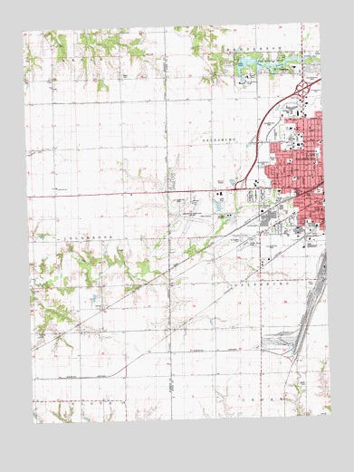
Galesburg West, IL USGS Topographic Map
Click on map above to begin viewing in our Map Viewer.

This topographic map contains these locations and features:
Feature Name Type Latitude Longitude GNIS ID View Map
Atchison School (historical)SchoolN40.9628°W90.4590°403692View Map
Barnett School (historical)SchoolN40.9445°W90.4887°403917View Map
Bateman SchoolSchoolN40.9592°W90.3782°1719583View Map
Bethany AcademySchoolN40.9406°W90.3765°1719586View Map
Bethany Baptist ChurchChurchN40.9409°W90.3765°1815929View Map
Bethel Baptist ChurchChurchN40.9620°W90.3762°1815930View Map
Blue Moonlight Drive-InLocaleN40.9486°W90.4186°2634152View Map
Brookside CemeteryCemeteryN40.9420°W90.4021°1719592View Map
Carl Sandburg CollegeSchoolN40.9817°W90.4076°1719598View Map
Church of ChristChurchN40.9589°W90.3860°1815940View Map
Churchill Junior High SchoolSchoolN40.9578°W90.3776°1719608View Map
City of GalesburgCivilN40.9506°W90.3763°2394842View Map
Clay CemeteryCemeteryN40.9180°W90.4397°1815942View Map
Clay School (historical)SchoolN40.9192°W90.4226°406188View Map
Coldbrook SchoolSchoolN40.9495°W90.4879°1719283View Map
Conard School (historical)SchoolN40.9336°W90.4601°406435View Map
Cooke SchoolSchoolN40.9367°W90.3826°1719613View Map
Covenant ChurchChurchN40.9667°W90.3807°1815944View Map
East Linwood CemeteryCemeteryN40.9459°W90.4012°1719629View Map
Emmanuel United Methodist ChurchChurchN40.9564°W90.3893°1815948View Map
Gale SchoolSchoolN40.9667°W90.3882°1719638View Map
Galesburg Fire Department Station 3 FreemontBuildingN40.9628°W90.3942°1815952View Map
Galesburg High SchoolSchoolN40.9634°W90.3885°1815965View Map
Galesburg Municipal AirportAirportN40.9439°W90.4296°427305View Map
Graham ParkParkN40.9473°W90.3849°1719643View Map
Hill Correctional CenterBuildingN40.9401°W90.4048°2574481View Map
Hope CemeteryCemeteryN40.9845°W90.4589°1719298View Map
Hope CemeteryCemeteryN40.9467°W90.3774°1719653View Map
Horney CemeteryCemeteryN40.9031°W90.4965°1719299View Map
Hurley School (historical)SchoolN40.8898°W90.4032°410707View Map
Kelly ParkParkN40.9456°W90.3807°1719655View Map
Knox CollegeSchoolN40.9434°W90.3754°1719658View Map
L T Stone SchoolSchoolN40.9509°W90.3874°1719699View Map
Lake StoreyReservoirN40.9874°W90.3991°1719700View Map
Lake Storey DamDamN40.9883°W90.4099°1691478View Map
Lake Storey ParkParkN40.9875°W90.3974°1719661View Map
Lewis CemeteryCemeteryN40.9836°W90.4023°1815985View Map
Linwood CemeteryCemeteryN40.9459°W90.4040°1719665View Map
Locust SchoolSchoolN40.9895°W90.4601°412499View Map
Memorial Park CemeteryCemeteryN40.9459°W90.4079°1719673View Map
Miles CemeteryCemeteryN40.9911°W90.4493°1719302View Map
Reorganized Church of Jesus Christ of Latter Day SaintsChurchN40.9523°W90.3929°1815993View Map
Rogers ParkParkN40.9364°W90.3754°1719687View Map
Rose Hoben Welch SchoolSchoolN40.9664°W90.3868°1719712View Map
Rotary ParkParkN40.9573°W90.3962°1719688View Map
Saint Josephs CemeteryCemeteryN40.9320°W90.4104°1719689View Map
Saint Patricks Roman Catholic ChurchChurchN40.9367°W90.3762°1815998View Map
Saluda Station (historical)LocaleN40.8842°W90.3946°1815999View Map
Sandburg MallLocaleN40.9723°W90.3879°1719693View Map
Springtown SchoolSchoolN40.8756°W90.4987°419013View Map
Steele SchoolSchoolN40.9467°W90.3943°1816003View Map
SurreyPopulated PlaceN40.9117°W90.4682°423224View Map
Swing ParkParkN40.9300°W90.4074°1719705View Map
Temple SholomChurchN40.9514°W90.3815°1816004View Map
Thirlwell School (historical)SchoolN40.9189°W90.3846°419653View Map
Township of ColdbrookCivilN40.9329°W90.4975°428828View Map
Township of Galesburg CityCivilN40.9506°W90.3763°429036View Map
Tylerville School (historical)SchoolN40.9884°W90.4968°420002View Map
UtahPopulated PlaceN40.9842°W90.4879°423270View Map
Utah Post Office (historical)Post OfficeN40.9767°W90.4662°1823741View Map
West Point School (historical)SchoolN40.9881°W90.4235°420898View Map
West School (historical)SchoolN40.9484°W90.4168°420916View Map

Note: Coordinates in the location and feature list above are referenced to NAD83 datum.


Copyright (C) 2008-2024 Ryan Niemi / Sunset Dynamics ... All Rights Reserved