TopoQuest Logo
Do you find TopoQuest useful?
Help keep TopoQuest running and adding new maps/features by donating!
Bitcoin:  19c7KJd3qBynnjoSw5npx9KScwjBe4ifkT
Litecoin:  LXs6TkuXGGXo1vDsWCkWVdjQX94eUKd6ui
Home View Maps Find Maps Find Places Resources & Links


Frogue, Kentucky Topographic Map

USGS Map Title: Frogue, KY
USGS Map MRC: 36085F3
DRG (GeoTIFF) Download: o36085f3.tif


Neighboring USGS Topographic Map Quads:


  Waterview, KY  
36085G4
 

  Burkesville, KY  
36085G3
 

  Wolf Creek Dam, KY  
36085G2
 

  Blacks Ferry, KY  
36085F4
 

  Frogue, KY  
36085F3
 

  Albany, KY  
36085F2
 

  Dale Hollow Dam, TN  
36085E4
 

  Dale Hollow Reservoir SE, TN  
36085E3
 

  Byrdstown, TN  
36085E2


Map MRC Location:

N37°
W86°
N37°
W85°
H8 H7 H6 H5 H4 H3 H2 H1
G8 G7 G6 G5 G4 G3 G2 G1
F8 F7 F6 F5 F4 F3 F2 F1
E8 E7 E6 E5 E4 E3 E2 E1
D8 D7 D6 D5 D4 D3 D2 D1
C8 C7 C6 C5 C4 C3 C2 C1
B8 B7 B6 B5 B4 B3 B2 B1
A8 A7 A6 A5 A4 A3 A2 A1
N36°
W86°
N36°
W85°

Frogue, KY USGS 1:24K Topographic Map Preview:
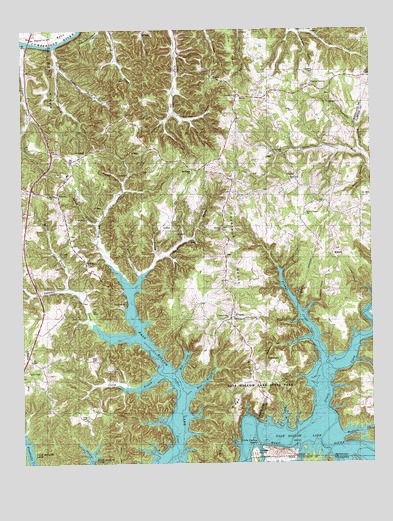
Frogue, KY USGS Topographic Map
Click on map above to begin viewing in our Map Viewer.

This topographic map contains these locations and features:
Feature Name Type Latitude Longitude GNIS ID View Map
Bend HollowValleyN36.6371°W85.3332°486845View Map
Boom RidgeRidgeN36.6331°W85.3030°487682View Map
Bow SchoolSchoolN36.7087°W85.3094°487728View Map
Boys IslandIslandN36.6273°W85.2836°1278134View Map
Brannan ChurchChurchN36.7309°W85.2947°487834View Map
Bryson Ford (historical)CrossingN36.6293°W85.2577°2565127View Map
Bybee HollowValleyN36.6790°W85.3331°488555View Map
Casey BranchStreamN36.6501°W85.3255°489039View Map
Cherry Tree Ridge School (historical)SchoolN36.6409°W85.3477°489416View Map
Chestnut Grove RidgeRidgeN36.6789°W85.2967°2567821View Map
Chestnut Grove SchoolSchoolN36.6659°W85.3011°489446View Map
Christian ChapelChurchN36.6901°W85.3575°489493View Map
Christian Chapel SchoolSchoolN36.6978°W85.3602°489494View Map
Clover CreekStreamN36.7459°W85.3750°489702View Map
Dale Hollow Lake State ParkParkN36.6536°W85.2915°2567979View Map
Dickens HollowValleyN36.7486°W85.2750°490874View Map
East Fork Raft CreekStreamN36.7390°W85.3600°491476View Map
Fannys CreekStreamN36.6542°W85.2672°491980View Map
FroguePopulated PlaceN36.6662°W85.2983°508044View Map
Gamblin BranchStreamN36.7142°W85.2529°492663View Map
Glidewell SchoolSchoolN36.6881°W85.2561°492919View Map
Grace CemeteryCemeteryN36.6545°W85.3491°493061View Map
Green GrovePopulated PlaceN36.7340°W85.2697°508126View Map
Green Grove RidgeRidgeN36.7298°W85.2686°2742612View Map
Greenbrier School (historical)SchoolN36.6529°W85.2665°2565182View Map
Guthrie BluffCliffN36.6415°W85.2888°2565183View Map
Hay HollowValleyN36.6386°W85.2886°2565185View Map
HegiraPopulated PlaceN36.7067°W85.2761°508218View Map
Herefords BendBendN36.7481°W85.3616°494082View Map
HobartPopulated PlaceN36.6840°W85.2630°508258View Map
Hobart Post Office (historical)Post OfficeN36.6856°W85.2636°2565188View Map
Hoot BranchStreamN36.6456°W85.3139°494510View Map
Huffakre ForkStreamN36.6315°W85.2602°494739View Map
Illwill CreekStreamN36.6323°W85.2722°494886View Map
Illwill Post Office (historical)Post OfficeN36.6298°W85.2554°2565189View Map
Jackson HollowValleyN36.6589°W85.2798°495125View Map
Jones BranchStreamN36.6345°W85.2816°495449View Map
KettlePopulated PlaceN36.7023°W85.3611°508385View Map
Kettle-Peytonsburg DivisionCivilN36.7281°W85.3500°1936965View Map
Lawson HollowValleyN36.6711°W85.2704°496091View Map
Little Cactus IslandIslandN36.6311°W85.2916°2565192View Map
Long CemeteryCemeteryN36.6381°W85.3522°497084View Map
Long RidgePopulated PlaceN36.7445°W85.2961°508500View Map
Lucky HollowValleyN36.6756°W85.2526°497335View Map
Midway ChurchChurchN36.6920°W85.3016°498168View Map
Mill CreekStreamN36.6584°W85.3180°498232View Map
ModocPopulated PlaceN36.7359°W85.3027°508622View Map
Mount Pisgah ChurchChurchN36.7092°W85.3111°498812View Map
Neeleys FerryLocaleN36.7470°W85.3716°499225View Map
New Sulphur ChurchChurchN36.7145°W85.3508°499403View Map
Nunn BranchStreamN36.6834°W85.3261°499635View Map
Pierce HollowValleyN36.6360°W85.2774°2565211View Map
Prichard HollowValleyN36.7062°W85.3387°501337View Map
Raft CreekStreamN36.7451°W85.3616°501521View Map
Riddle ProngStreamN36.6809°W85.3275°501837View Map
Rose of Sharon Methodist ChurchChurchN36.6969°W85.2735°502313View Map
Scott RidgeRidgeN36.7348°W85.3630°503105View Map
Sexton Fork ChurchChurchN36.7142°W85.2794°503197View Map
Spears ChapelChurchN36.6512°W85.3730°504042View Map
Spring BranchStreamN36.6937°W85.3466°504099View Map
Spurlins HollowValleyN36.7156°W85.2615°504190View Map
Stony Point SchoolSchoolN36.7162°W85.3472°504520View Map
Store HollowValleyN36.7101°W85.2506°504525View Map
Storehouse HollowValleyN36.7262°W85.3203°504528View Map
Sulphur School (historical)SchoolN36.6265°W85.2666°1320179View Map
Trooper IslandIslandN36.6276°W85.2925°487781View Map
Vincent CemeteryCemeteryN36.7376°W85.2691°506050View Map
Vincent SchoolSchoolN36.7328°W85.2836°506052View Map
Williams CreekStreamN36.6753°W85.3364°506813View Map
Willis BranchStreamN36.6745°W85.3566°506845View Map

Note: Coordinates in the location and feature list above are referenced to NAD83 datum.


Copyright (C) 2008-2024 Ryan Niemi / Sunset Dynamics ... All Rights Reserved