TopoQuest Logo
Do you find TopoQuest useful?
Help keep TopoQuest running and adding new maps/features by donating!
Bitcoin:  19c7KJd3qBynnjoSw5npx9KScwjBe4ifkT
Litecoin:  LXs6TkuXGGXo1vDsWCkWVdjQX94eUKd6ui
Home View Maps Find Maps Find Places Resources & Links


Fall Creek Lake, Oregon Topographic Map

USGS Map Title: Fall Creek Lake, OR
USGS Map MRC: 43122H6
DRG (GeoTIFF) Download: o43122h6.tif


Neighboring USGS Topographic Map Quads:


  Walterville, OR  
44122A7
 

  Leaburg, OR  
44122A6
 

  Goat Point, OR  
44122A5
 

  Lowell, OR  
43122H7
 

  Fall Creek Lake, OR  
43122H6
 

  Saddleblanket Mountain, OR  
43122H5
 

  Kloster Mountain, OR  
43122G7
 

  Mount June, OR  
43122G6
 

  Westfir West, OR  
43122G5


Map MRC Location:

N44°
W123°
N44°
W122°
H8 H7 H6 H5 H4 H3 H2 H1
G8 G7 G6 G5 G4 G3 G2 G1
F8 F7 F6 F5 F4 F3 F2 F1
E8 E7 E6 E5 E4 E3 E2 E1
D8 D7 D6 D5 D4 D3 D2 D1
C8 C7 C6 C5 C4 C3 C2 C1
B8 B7 B6 B5 B4 B3 B2 B1
A8 A7 A6 A5 A4 A3 A2 A1
N43°
W123°
N43°
W122°

Fall Creek Lake, OR USGS 1:24K Topographic Map Preview:
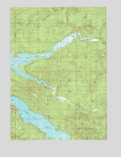
Fall Creek Lake, OR USGS Topographic Map
Click on map above to begin viewing in our Map Viewer.

This topographic map contains these locations and features:
Feature Name Type Latitude Longitude GNIS ID View Map
Alder CreekStreamN43.9085°W122.6637°1137064View Map
Bear MountainSummitN43.9363°W122.6361°1137728View Map
Burgess (historical)LocaleN43.8971°W122.7178°1166251View Map
Carter (historical)LocaleN43.9068°W122.7331°1166252View Map
Cascara Campground Boat RampLocaleN43.9709°W122.6688°2668283View Map
Deer MountainSummitN43.9903°W122.6552°1140858View Map
Disgust CreekStreamN43.8818°W122.7095°1153371View Map
East Fork Minnow CreekStreamN43.8904°W122.7348°1141585View Map
Egypt Post Office (historical)Post OfficeN43.9610°W122.6901°1164329View Map
Fairview MountainSummitN43.9205°W122.6768°1141951View Map
Fall Creek LakeReservoirN43.9512°W122.7218°1158871View Map
Fall Creek Reservoir State ParkParkN43.9415°W122.7478°1135573View Map
Green ButteSummitN43.9099°W122.6441°1143024View Map
Green MountainSummitN43.9817°W122.6516°1143043View Map
GreentopSummitN43.9434°W122.6573°1143070View Map
Horn ButteSummitN43.9325°W122.6749°1143730View Map
Hyde CreekStreamN43.9707°W122.6456°1153374View Map
Landax Landing ParkParkN43.8957°W122.7012°1162178View Map
Little Fall Creek Picnic AreaLocaleN43.9798°W122.7420°1135572View Map
Little Gold CreekStreamN43.9657°W122.6259°1145171View Map
Lowell DivisionCivilN43.9390°W122.6328°1938048View Map
MinnowLocaleN43.8996°W122.7409°1146341View Map
Minnow CreekStreamN43.8921°W122.7331°1146343View Map
Mount SalemSummitN43.9300°W122.6437°1148958View Map
Murphy CreekStreamN43.9693°W122.6498°1153373View Map
Nelson CreekStreamN43.9243°W122.6981°1146768View Map
North Fork Fall CreekStreamN43.9701°W122.6370°1146952View Map
North Shore Recreation SiteLocaleN43.9560°W122.7495°1156121View Map
Norton CreekStreamN43.9915°W122.6998°1147080View Map
Rolling Riffle CreekStreamN43.8790°W122.7031°1148708View Map
Signal (historical)LocaleN43.8860°W122.6956°1166258View Map
Signal Point Boat RampLocaleN43.8835°W122.6886°2668148View Map
Sky CampLocaleN43.9493°W122.7262°1135575View Map
Timber CreekStreamN43.9721°W122.6748°1153372View Map
Upper End CampgroundLocaleN43.9721°W122.6667°1135574View Map
Wimble PassGapN43.9090°W122.7053°1135571View Map
WinberryPopulated PlaceN43.9535°W122.7126°1152470View Map
Winberry CreekStreamN43.9210°W122.6948°1152471View Map
Winberry Day Use Area Boat RampLocaleN43.9403°W122.7473°2668131View Map
Winberry Post Office (historical)Post OfficeN43.9535°W122.7126°1166195View Map

Note: Coordinates in the location and feature list above are referenced to NAD83 datum.


Copyright (C) 2008-2024 Ryan Niemi / Sunset Dynamics ... All Rights Reserved