TopoQuest Logo
Do you find TopoQuest useful?
Help keep TopoQuest running and adding new maps/features by donating!
Bitcoin:  19c7KJd3qBynnjoSw5npx9KScwjBe4ifkT
Litecoin:  LXs6TkuXGGXo1vDsWCkWVdjQX94eUKd6ui
Home View Maps Find Maps Find Places Resources & Links


Falcon, Arkansas Topographic Map

USGS Map Title: Falcon, AR
USGS Map MRC: 33093D4
DRG (GeoTIFF) Download: o33093d4.tif


Neighboring USGS Topographic Map Quads:


  Patmos, AR  
33093E5
 

  Bodcaw, AR  
33093E4
 

  Willisville, AR  
33093E3
 

  Old Town, AR  
33093D5
 

  Falcon, AR  
33093D4
 

  Lamartine, AR  
33093D3
 

  Lewisville, AR  
33093C5
 

  Buckner, AR  
33093C4
 

  Waldo, AR  
33093C3


Map MRC Location:

N34°
W94°
N34°
W93°
H8 H7 H6 H5 H4 H3 H2 H1
G8 G7 G6 G5 G4 G3 G2 G1
F8 F7 F6 F5 F4 F3 F2 F1
E8 E7 E6 E5 E4 E3 E2 E1
D8 D7 D6 D5 D4 D3 D2 D1
C8 C7 C6 C5 C4 C3 C2 C1
B8 B7 B6 B5 B4 B3 B2 B1
A8 A7 A6 A5 A4 A3 A2 A1
N33°
W94°
N33°
W93°

Falcon, AR USGS 1:24K Topographic Map Preview:
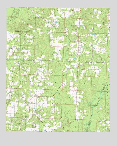
Falcon, AR USGS Topographic Map
Click on map above to begin viewing in our Map Viewer.

This topographic map contains these locations and features:
Feature Name Type Latitude Longitude GNIS ID View Map
Clark CemeteryCemeteryN33.4748°W93.4807°47798View Map
Clevet Springs ChurchChurchN33.4596°W93.3971°47852View Map
Cummings CemeteryCemeteryN33.4582°W93.4877°48258View Map
FalconPopulated PlaceN33.4646°W93.4135°57742View Map
Falcon CemeteryCemeteryN33.4665°W93.4202°48990View Map
Falcon Oil and Gas FieldOilfieldN33.4540°W93.4088°48991View Map
Jones BranchStreamN33.4357°W93.4374°50713View Map
Knotts BranchStreamN33.4671°W93.4255°50901View Map
KZHE-FM (Stamps)TowerN33.4337°W93.4638°85432View Map
Lone Pine School (historical)SchoolN33.4762°W93.4743°60368View Map
Marlers LakeReservoirN33.4735°W93.3960°80230View Map
Marlers Lake DamDamN33.4735°W93.3935°80229View Map
Mount PleasantPopulated PlaceN33.4587°W93.4938°57131View Map
Pleasant Grove ChurchChurchN33.4151°W93.4624°53533View Map
Sardis ChurchChurchN33.4062°W93.4957°54591View Map
ShilohPopulated PlaceN33.3887°W93.4599°57188View Map
Shiloh Lookout TowerTowerN33.3921°W93.4649°82553View Map
Shiloh Oil and Gas FieldOilfieldN33.3790°W93.4435°54803View Map
Stamps Oil and Gas FieldOilfieldN33.3898°W93.4780°55148View Map
Township of AlabamaCivilN33.4819°W93.4041°68897View Map
Wilson LakeReservoirN33.4919°W93.4074°81028View Map
Wilson Lake DamDamN33.4918°W93.4085°81027View Map
Wood Springs ChurchChurchN33.4379°W93.4055°56513View Map

Note: Coordinates in the location and feature list above are referenced to NAD83 datum.


Copyright (C) 2008-2024 Ryan Niemi / Sunset Dynamics ... All Rights Reserved