TopoQuest Logo
Do you find TopoQuest useful?
Help keep TopoQuest running and adding new maps/features by donating!
Bitcoin:  19c7KJd3qBynnjoSw5npx9KScwjBe4ifkT
Litecoin:  LXs6TkuXGGXo1vDsWCkWVdjQX94eUKd6ui
Home View Maps Find Maps Find Places Resources & Links


Fairfield SE, Nebraska Topographic Map

USGS Map Title: Fairfield SE, NE
USGS Map MRC: 40098C1
DRG (GeoTIFF) Download: o40098c1.tif


Neighboring USGS Topographic Map Quads:


  Fairfield NW, NE  
40098D2
 

  Fairfield, NE  
40098D1
 

  Edgar NW, NE  
40097D8
 

  Deweese, NE  
40098C2
 

  Fairfield SE, NE  
40098C1
 

  Edgar, NE  
40097C8
 

  Mount Clare, NE  
40098B2
 

  Nelson, NE  
40098B1
 

  Oak, NE  
40097B8


Map MRC Location:

N41°
W99°
N41°
W98°
H8 H7 H6 H5 H4 H3 H2 H1
G8 G7 G6 G5 G4 G3 G2 G1
F8 F7 F6 F5 F4 F3 F2 F1
E8 E7 E6 E5 E4 E3 E2 E1
D8 D7 D6 D5 D4 D3 D2 D1
C8 C7 C6 C5 C4 C3 C2 C1
B8 B7 B6 B5 B4 B3 B2 B1
A8 A7 A6 A5 A4 A3 A2 A1
N40°
W99°
N40°
W98°

Fairfield SE, NE USGS 1:24K Topographic Map Preview:
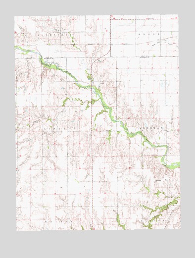
Fairfield SE, NE USGS Topographic Map
Click on map above to begin viewing in our Map Viewer.

This topographic map contains these locations and features:
Feature Name Type Latitude Longitude GNIS ID View Map
Bethany SchoolSchoolN40.3728°W98.0234°827370View Map
Bluewing State Wildlife Management AreaParkN40.3667°W98.0420°1882357View Map
Buffalo CreekStreamN40.3328°W98.0667°827745View Map
Drudik DamDamN40.2833°W98.1067°1767238View Map
Drudik ReservoirLakeN40.2824°W98.1084°1767239View Map
East Buffalo SchoolSchoolN40.3656°W98.0714°828949View Map
Edgar Historical MarkerParkN40.3722°W98.0514°1882425View Map
Hoyt DamDamN40.3687°W98.0665°1769928View Map
Hoyt ReservoirReservoirN40.3683°W98.0686°1769929View Map
Indian Raids Historical MarkerParkN40.3292°W98.0675°1882700View Map
Jones DamDamN40.3118°W98.0638°1769856View Map
Jones DamDamN40.3255°W98.0310°1769910View Map
Jones ReservoirReservoirN40.3107°W98.0644°1769857View Map
Jones ReservoirLakeN40.3262°W98.0316°1769911View Map
Liberty Election Precinct (historical)CivilN40.3050°W98.1075°1929020View Map
Mazour Dam-1 DamDamN40.3054°W98.1057°1767208View Map
Mazour ReservoirReservoirN40.3049°W98.1087°1767209View Map
Oxbow CemeteryCemeteryN40.2561°W98.0284°831939View Map
Oxbow SchoolSchoolN40.2783°W98.0153°831941View Map
Pleasant Hill CemeteryCemeteryN40.3147°W98.1231°832171View Map
Pleasant View SchoolSchoolN40.3053°W98.0675°832255View Map
Ruttman DamDamN40.2700°W98.0403°1767192View Map
Ruttman ReservoirReservoirN40.2712°W98.0414°1767193View Map
Smartweed Marsh State Wildlife Management AreaParkN40.3333°W98.0114°1882623View Map
Smartweed Marsh West State Wildlife Management AreaParkN40.3417°W98.0392°1882624View Map
Smith CemeteryCemeteryN40.3078°W98.0570°833494View Map
Township of LibertyCivilN40.3056°W98.1003°1882655View Map
Township of NelsonCivilN40.2506°W98.1003°1882654View Map
Walnut CreekStreamN40.3270°W98.0606°834447View Map
Whithorn-Brown DamDamN40.2715°W98.0201°1767438View Map
Whithorn-Brown ReservoirReservoirN40.2723°W98.0230°1767439View Map
Wroughton DamDamN40.2674°W98.0893°1767440View Map
Wroughton ReservoirLakeN40.2679°W98.0900°1767441View Map

Note: Coordinates in the location and feature list above are referenced to NAD83 datum.


Copyright (C) 2008-2024 Ryan Niemi / Sunset Dynamics ... All Rights Reserved