TopoQuest Logo
Do you find TopoQuest useful?
Help keep TopoQuest running and adding new maps/features by donating!
Bitcoin:  19c7KJd3qBynnjoSw5npx9KScwjBe4ifkT
Litecoin:  LXs6TkuXGGXo1vDsWCkWVdjQX94eUKd6ui
Home View Maps Find Maps Find Places Resources & Links


Erin, Tennessee Topographic Map

USGS Map Title: Erin, TN
USGS Map MRC: 36087C6
DRG (GeoTIFF) Download: o36087c6.tif


Neighboring USGS Topographic Map Quads:


  Dover, TN  
36087D7
 

  Cumberland City, TN  
36087D6
 

  Needmore, TN  
36087D5
 

  Stewart, TN  
36087C7
 

  Erin, TN  
36087C6
 

  Ellis Mills, TN  
36087C5
 

  Halls Creek, TN  
36087B7
 

  Woolworth, TN  
36087B6
 

  Ruskin, TN  
36087B5


Map MRC Location:

N37°
W88°
N37°
W87°
H8 H7 H6 H5 H4 H3 H2 H1
G8 G7 G6 G5 G4 G3 G2 G1
F8 F7 F6 F5 F4 F3 F2 F1
E8 E7 E6 E5 E4 E3 E2 E1
D8 D7 D6 D5 D4 D3 D2 D1
C8 C7 C6 C5 C4 C3 C2 C1
B8 B7 B6 B5 B4 B3 B2 B1
A8 A7 A6 A5 A4 A3 A2 A1
N36°
W88°
N36°
W87°

Erin, TN USGS 1:24K Topographic Map Preview:
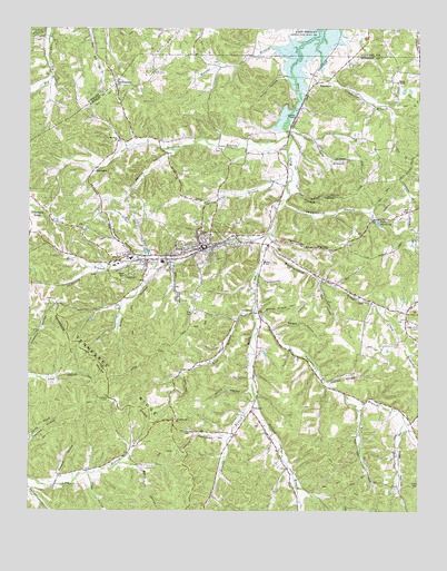
Erin, TN USGS Topographic Map
Click on map above to begin viewing in our Map Viewer.

This topographic map contains these locations and features:
Feature Name Type Latitude Longitude GNIS ID View Map
Alsobrook CemeteryCemeteryN36.2800°W87.6795°1309067View Map
ArlingtonPopulated PlaceN36.3145°W87.7131°1309075View Map
Arlington RidgeRidgeN36.3078°W87.7306°1647119View Map
Arlington School (historical)SchoolN36.3137°W87.7142°1309076View Map
Ashland Furnace (historical)LocaleN36.3384°W87.7292°1309082View Map
Averitt BranchStreamN36.2798°W87.6770°1276008View Map
Bateman BranchStreamN36.3023°W87.6770°1276452View Map
Bateman School (historical)SchoolN36.2770°W87.6422°1309063View Map
Beech HollowValleyN36.2974°W87.6714°1276850View Map
Black HollowValleyN36.2617°W87.7151°1277579View Map
Boone HollowValleyN36.2844°W87.6798°1647117View Map
Booster BranchStreamN36.3698°W87.6642°1277988View Map
Bratschi CemeteryCemeteryN36.2898°W87.6858°1309068View Map
Brigham BranchStreamN36.3481°W87.6672°1305417View Map
BrownsvillePopulated PlaceN36.3601°W87.7225°1278633View Map
Byron Forge (historical)LocaleN36.3684°W87.6803°1308806View Map
Campground ChurchChurchN36.3017°W87.6778°1279479View Map
Campground School (historical)SchoolN36.3020°W87.6775°1309070View Map
Carter HollowValleyN36.3629°W87.6678°1279815View Map
Cave Orchard BranchStreamN36.3512°W87.6672°1279934View Map
Cave Orchard School (historical)SchoolN36.3484°W87.6672°1309085View Map
Cedar Hill CemeteryCemeteryN36.2978°W87.6252°1269430View Map
Cedar Hill School (historical)SchoolN36.3020°W87.6281°1309088View Map
Cedar Valley CemeteryCemeteryN36.3020°W87.6395°1316119View Map
Cedar Valley ChurchChurchN36.3039°W87.6400°1305789View Map
City of ErinCivilN36.3160°W87.7025°2403569View Map
Clark BranchStreamN36.3039°W87.6386°1280589View Map
Commissioner District 3CivilN36.3144°W87.6960°2464159View Map
Commissioner District 4CivilN36.2635°W87.7189°2464050View Map
Commissioner District 6CivilN36.3456°W87.6742°2464544View Map
DenmarkPopulated PlaceN36.3384°W87.7292°1314942View Map
Denmark School (historical)SchoolN36.3414°W87.7261°1309083View Map
Dobbs HollowValleyN36.2538°W87.6909°1647116View Map
DolomitePopulated PlaceN36.3612°W87.6578°1314962View Map
ErinPopulated PlaceN36.3184°W87.6947°1283839View Map
Erin BranchStreamN36.3214°W87.6736°1283840View Map
Erin CemeteryCemeteryN36.3217°W87.6911°1316121View Map
Erin CemeteryCemeteryN36.3023°W87.6981°1283841View Map
Erin City HallBuildingN36.3184°W87.6931°1309072View Map
Erin Division (historical)CensusN36.2981°W87.6453°1648787View Map
Erin Elementary SchoolSchoolN36.3148°W87.6745°1648319View Map
Erin Fire DepartmentBuildingN36.3185°W87.6930°2653728View Map
Erin Police DepartmentBuildingN36.3184°W87.6930°2765986View Map
Erin Post OfficePost OfficeN36.3156°W87.7132°1649802View Map
Finch HollowValleyN36.2858°W87.7010°1284260View Map
Hagerville BranchStreamN36.3303°W87.6681°1647121View Map
Haggieville HollowValleyN36.3302°W87.6680°1286495View Map
Hendricks HollowValleyN36.2692°W87.6865°1287397View Map
Houston CountyCivilN36.2860°W87.7170°1648578View Map
Houston County Ambulance ServiceBuildingN36.3156°W87.7120°2697410View Map
Houston County CourthouseBuildingN36.3184°W87.6945°1309089View Map
Houston County High SchoolSchoolN36.3156°W87.7175°1309078View Map
Houston County Sheriff's OfficeBuildingN36.3606°W87.6550°2765760View Map
Jennie HollowValleyN36.2810°W87.6791°1289372View Map
Kennedy CemeteryCemeteryN36.3434°W87.6886°1309084View Map
Kizer RidgeRidgeN36.3628°W87.6403°1647120View Map
Lickskillet BranchStreamN36.3723°W87.6570°1291255View Map
Lockart ChapelChurchN36.3517°W87.6653°1306698View Map
Lockhart CemeteryCemeteryN36.3123°W87.6747°1309071View Map
Long Branch School (historical)SchoolN36.2673°W87.7159°1309079View Map
Marable HollowValleyN36.3332°W87.6640°1292652View Map
McMillian CemeteryCemeteryN36.3167°W87.7178°1309077View Map
MidwayPopulated PlaceN36.3142°W87.7039°1309074View Map
Mount Sinai ChurchChurchN36.3464°W87.7217°1306789View Map
Mount Zion Church (historical)ChurchN36.3567°W87.7347°1308912View Map
Musterground CreekStreamN36.3217°W87.6731°1295169View Map
Owl HollowValleyN36.3144°W87.7033°1296601View Map
Peach Grove ChurchChurchN36.2737°W87.7025°1297044View Map
PollardPopulated PlaceN36.2762°W87.6781°1298066View Map
Pollard BranchStreamN36.2798°W87.6770°1298068View Map
Pollard CemeteryCemeteryN36.2720°W87.6761°1309066View Map
Pollard School (historical)SchoolN36.2667°W87.6692°1309065View Map
Powers HollowValleyN36.2833°W87.6541°1298439View Map
Price HollowValleyN36.2596°W87.7305°1298516View Map
Pulley HollowValleyN36.3530°W87.6332°1309087View Map
Reuben HollowValleyN36.2558°W87.7499°1299237View Map
Robbins HollowValleyN36.2586°W87.7406°1299590View Map
Rocky HollowValleyN36.3143°W87.7070°1299905View Map
Ross BranchStreamN36.3023°W87.6770°1300110View Map
Rye HollowValleyN36.2765°W87.6440°1300377View Map
Sage HollowValleyN36.2710°W87.6305°1269921View Map
Schmid Airport (historical)AirportN36.3667°W87.6667°1301418View Map
Schmidt HollowValleyN36.3697°W87.6683°1308965View Map
Secret Prayer HollowValleyN36.3007°W87.6746°1301026View Map
Sinks CemeteryCemeteryN36.2992°W87.6328°1316122View Map
Slaughter HollowValleyN36.3170°W87.7165°1270491View Map
South Moore HollowValleyN36.2608°W87.7307°1309080View Map
Spring BranchStreamN36.3370°W87.6659°1271053View Map
Starspring HollowValleyN36.2815°W87.6541°1309064View Map
Steels ChapelChurchN36.3612°W87.6320°1303819View Map
Tab HollowValleyN36.3098°W87.6567°1272022View Map
Tantrough HollowValleyN36.3207°W87.6712°1272095View Map
Tennessee Department of Agriculture Division of Forestry Erin Fire TowerBuildingN36.2856°W87.7253°2654143View Map
Trinity HospitalHospitalN36.3203°W87.6896°1309073View Map
Union Furnace (historical)LocaleN36.3556°W87.6356°1309086View Map
Wallace HollowValleyN36.3427°W87.7049°1273685View Map
Weaver CemeteryCemeteryN36.3006°W87.6931°1309069View Map
Weaver HollowValleyN36.2970°W87.7223°1647118View Map
Winters HollowValleyN36.2685°W87.6718°1647127View Map

Note: Coordinates in the location and feature list above are referenced to NAD83 datum.


Copyright (C) 2008-2024 Ryan Niemi / Sunset Dynamics ... All Rights Reserved