TopoQuest Logo
Do you find TopoQuest useful?
Help keep TopoQuest running and adding new maps/features by donating!
Bitcoin:  19c7KJd3qBynnjoSw5npx9KScwjBe4ifkT
Litecoin:  LXs6TkuXGGXo1vDsWCkWVdjQX94eUKd6ui
Home View Maps Find Maps Find Places Resources & Links


Epes West, Alabama Topographic Map

USGS Map Title: Epes West, AL
USGS Map MRC: 32088F2
DRG (GeoTIFF) Download: o32088f2.tif


Neighboring USGS Topographic Map Quads:


  Geiger, AL  
32088G3
 

  Gainesville, AL  
32088G2
 

  Boligee, AL  
32088G1
 

  Emelle, AL  
32088F3
 

  Epes West, AL  
32088F2
 

  Epes East, AL  
32088F1
 

  Boyd, AL  
32088E3
 

  Livingston, AL  
32088E2
 

  Brewersville, AL  
32088E1


Map MRC Location:

N33°
W89°
N33°
W88°
H8 H7 H6 H5 H4 H3 H2 H1
G8 G7 G6 G5 G4 G3 G2 G1
F8 F7 F6 F5 F4 F3 F2 F1
E8 E7 E6 E5 E4 E3 E2 E1
D8 D7 D6 D5 D4 D3 D2 D1
C8 C7 C6 C5 C4 C3 C2 C1
B8 B7 B6 B5 B4 B3 B2 B1
A8 A7 A6 A5 A4 A3 A2 A1
N32°
W89°
N32°
W88°

Epes West, AL USGS 1:24K Topographic Map Preview:
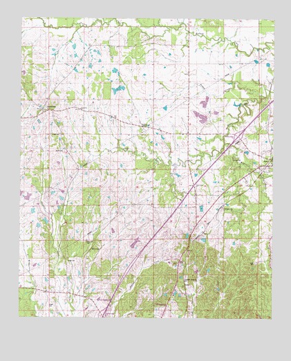
Epes West, AL USGS Topographic Map
Click on map above to begin viewing in our Map Viewer.

This topographic map contains these locations and features:
Feature Name Type Latitude Longitude GNIS ID View Map
Abe BranchStreamN32.7035°W88.1395°689854View Map
Bethel ChurchChurchN32.7107°W88.2386°158424View Map
Brown CemeteryCemeteryN32.6943°W88.2286°114986View Map
Brown CemeteryCemeteryN32.7015°W88.2303°114987View Map
Browns Chapel (historical)ChurchN32.7310°W88.1556°134099View Map
Cockerell BranchStreamN32.6418°W88.2147°134114View Map
EpesPopulated PlaceN32.6904°W88.1261°118012View Map
Epes Post OfficePost OfficeN32.6920°W88.1262°168880View Map
Epes Volunteer Fire DepartmentBuildingN32.6883°W88.1263°2691467View Map
Eskeridge Pettigrew CemeteryCemeteryN32.6409°W88.1689°118026View Map
Ezell School (historical)SchoolN32.7321°W88.1653°134132View Map
Harris CemeteryCemeteryN32.6785°W88.1475°158430View Map
Henagan CemeteryCemeteryN32.6710°W88.1496°119945View Map
Interchange 17CrossingN32.6257°W88.2084°155707View Map
Interchange 23CrossingN32.7010°W88.1425°155708View Map
Jones Creek ChurchChurchN32.6804°W88.1625°121013View Map
Jones Creek School (historical)SchoolN32.6807°W88.1628°134170View Map
Lewis CemeteryCemeteryN32.6482°W88.1339°121517View Map
Little Rock Church (historical)ChurchN32.7329°W88.1611°134176View Map
Livingston DivisionCivilN32.6283°W88.2002°165957View Map
McCainvillePopulated PlaceN32.6529°W88.2147°156675View Map
McCainville CemeteryCemeteryN32.6562°W88.2170°122458View Map
McCainville CreekStreamN32.6279°W88.2220°134182View Map
McInnis CemeteryCemeteryN32.6912°W88.1450°122560View Map
ParkerPopulated PlaceN32.6387°W88.1678°156858View Map
Parker CemeteryCemeteryN32.6308°W88.2345°163657View Map
Shiloh Baptist ChurchChurchN32.6482°W88.2261°158134View Map
Shiloh CemeteryCemeteryN32.6488°W88.2262°126719View Map
Shiloh School (historical)SchoolN32.6493°W88.2261°134252View Map
SumtervillePopulated PlaceN32.7118°W88.2389°153610View Map
Sumterville Baptist ChurchChurchN32.7087°W88.2417°158435View Map
Sumterville ChurchChurchN32.7121°W88.2200°127552View Map
Town of EpesCivilN32.6912°W88.1269°2406456View Map
Turkey CreekStreamN32.7179°W88.1309°128143View Map
Wiggins CreekStreamN32.6979°W88.1486°128944View Map

Note: Coordinates in the location and feature list above are referenced to NAD83 datum.


Copyright (C) 2008-2024 Ryan Niemi / Sunset Dynamics ... All Rights Reserved