TopoQuest Logo
Do you find TopoQuest useful?
Help keep TopoQuest running and adding new maps/features by donating!
Bitcoin:  19c7KJd3qBynnjoSw5npx9KScwjBe4ifkT
Litecoin:  LXs6TkuXGGXo1vDsWCkWVdjQX94eUKd6ui
Home View Maps Find Maps Find Places Resources & Links


English, Indiana Topographic Map

USGS Map Title: English, IN
USGS Map MRC: 38086C4
DRG (GeoTIFF) Download: o38086c4.tif


Neighboring USGS Topographic Map Quads:


  Greenbrier, IN  
38086D5
 

  Valeene, IN  
38086D4
 

  Hardinsburg, IN  
38086D3
 

  Taswell, IN  
38086C5
 

  English, IN  
38086C4
 

  Milltown, IN  
38086C3
 

  Branchville, IN  
38086B5
 

  Beechwood, IN  
38086B4
 

  Leavenworth, IN  
38086B3


Map MRC Location:

N39°
W87°
N39°
W86°
H8 H7 H6 H5 H4 H3 H2 H1
G8 G7 G6 G5 G4 G3 G2 G1
F8 F7 F6 F5 F4 F3 F2 F1
E8 E7 E6 E5 E4 E3 E2 E1
D8 D7 D6 D5 D4 D3 D2 D1
C8 C7 C6 C5 C4 C3 C2 C1
B8 B7 B6 B5 B4 B3 B2 B1
A8 A7 A6 A5 A4 A3 A2 A1
N38°
W87°
N38°
W86°

English, IN USGS 1:24K Topographic Map Preview:
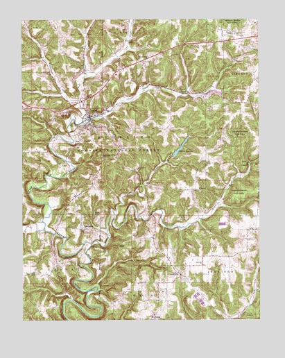
English, IN USGS Topographic Map
Click on map above to begin viewing in our Map Viewer.

This topographic map contains these locations and features:
Feature Name Type Latitude Longitude GNIS ID View Map
Bird Hollow CreekStreamN38.3326°W86.4683°450682View Map
Bluegill PondLakeN38.3725°W86.4223°446893View Map
Bogard ChurchChurchN38.3056°W86.3908°431287View Map
Bogard CreekStreamN38.2817°W86.4639°431288View Map
Brownstown CreekStreamN38.3409°W86.4697°450720View Map
Brushy CreekStreamN38.2945°W86.4514°431687View Map
Camp Fork CreekStreamN38.3348°W86.4580°432033View Map
Crawford CountyCivilN38.2924°W86.4517°451674View Map
Crawford County Ambulance ServiceBuildingN38.3546°W86.4481°2719268View Map
Crawford County Sheriff's OfficeBuildingN38.3528°W86.4464°2758066View Map
Cunningham CemeteryCemeteryN38.3131°W86.4394°433248View Map
CurbyPopulated PlaceN38.2876°W86.3772°433254View Map
Denbo CemeteryCemeteryN38.3315°W86.4727°433468View Map
Dillman ChurchChurchN38.2834°W86.3814°433554View Map
Dog CreekStreamN38.3509°W86.4658°450858View Map
EnglishPopulated PlaceN38.3345°W86.4641°434203View Map
English ReservoirReservoirN38.3210°W86.4171°434207View Map
English SchoolSchoolN38.3376°W86.4561°446517View Map
English Volunteer Fire DepartmentBuildingN38.3533°W86.4456°2625676View Map
English Water Supply DamReservoirN38.3184°W86.4200°447269View Map
Grant CemeteryCemeteryN38.2945°W86.4730°435317View Map
Grant LakeLakeN38.2943°W86.4621°435323View Map
GrantsburgPopulated PlaceN38.2881°W86.4694°449662View Map
Hamilton CemeteryCemeteryN38.3151°W86.4776°435639View Map
Hilands Overlook State ParkParkN38.3173°W86.4569°436179View Map
Land CemeteryCemeteryN38.3353°W86.4758°437596View Map
Mathers ChapelChurchN38.3595°W86.4333°438714View Map
Mount Sterling ChurchChurchN38.3040°W86.4069°439700View Map
Otter CreekStreamN38.2876°W86.4883°451308View Map
RiddlePopulated PlaceN38.2506°W86.4305°441984View Map
Roberson AirportAirportN38.3203°W86.4887°2677108View Map
Rock Springs ChurchChurchN38.3692°W86.4439°442214View Map
Seton CemeteryCemeteryN38.2788°W86.4558°443219View Map
Seton KnobSummitN38.2806°W86.4497°443220View Map
Simpson ChapelChurchN38.3692°W86.3889°443532View Map
Sloan CemeteryCemeteryN38.3423°W86.4664°443613View Map
Stewart CemeteryCemeteryN38.3684°W86.4691°444146View Map
Switzer CrossroadsPopulated PlaceN38.2690°W86.4166°452495View Map
TemplePopulated PlaceN38.3445°W86.4158°444626View Map
Temple QuarryMineN38.3428°W86.4036°2649698View Map
Town of EnglishCivilN38.3408°W86.4592°2396928View Map
Township of SterlingCivilN38.3363°W86.4530°453873View Map
Union ChapelChurchN38.2695°W86.4958°445080View Map

Note: Coordinates in the location and feature list above are referenced to NAD83 datum.


Copyright (C) 2008-2024 Ryan Niemi / Sunset Dynamics ... All Rights Reserved