TopoQuest Logo
Do you find TopoQuest useful?
Help keep TopoQuest running and adding new maps/features by donating!
Bitcoin:  19c7KJd3qBynnjoSw5npx9KScwjBe4ifkT
Litecoin:  LXs6TkuXGGXo1vDsWCkWVdjQX94eUKd6ui
Home View Maps Find Maps Find Places Resources & Links


Elsey, Missouri Topographic Map

USGS Map Title: Elsey, MO
USGS Map MRC: 36093G5
DRG (GeoTIFF) Download: o36093g5.tif


Neighboring USGS Topographic Map Quads:


  Aurora, MO  
36093H6
 

  Crane, MO  
36093H5
 

  Hurley, MO  
36093H4
 

  Jenkins, MO  
36093G6
 

  Elsey, MO  
36093G5
 

  Galena, MO  
36093G4
 

  Shell Knob, MO  
36093F6
 

  Cape Fair, MO  
36093F5
 

  Reeds Spring, MO  
36093F4


Map MRC Location:

N37°
W94°
N37°
W93°
H8 H7 H6 H5 H4 H3 H2 H1
G8 G7 G6 G5 G4 G3 G2 G1
F8 F7 F6 F5 F4 F3 F2 F1
E8 E7 E6 E5 E4 E3 E2 E1
D8 D7 D6 D5 D4 D3 D2 D1
C8 C7 C6 C5 C4 C3 C2 C1
B8 B7 B6 B5 B4 B3 B2 B1
A8 A7 A6 A5 A4 A3 A2 A1
N36°
W94°
N36°
W93°

Elsey, MO USGS 1:24K Topographic Map Preview:
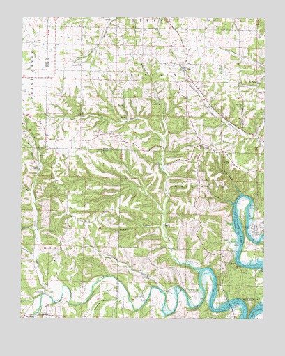
Elsey, MO USGS Topographic Map
Click on map above to begin viewing in our Map Viewer.

This topographic map contains these locations and features:
Feature Name Type Latitude Longitude GNIS ID View Map
Ashcraft Camp (historical)LocaleN36.8012°W93.5074°2645954View Map
Baptist HollowValleyN36.7759°W93.6182°713629View Map
Big SpringSpringN36.8392°W93.5530°714215View Map
Big Spring HollowValleyN36.8328°W93.5521°714225View Map
Bowling ChapelChurchN36.8556°W93.5946°714584View Map
Builderback HollowValleyN36.7515°W93.5513°749104View Map
Caraway Camp (historical)LocaleN36.7832°W93.5042°2645953View Map
Carney CemeteryCemeteryN36.7606°W93.6132°715409View Map
Carney CreekStreamN36.7634°W93.6035°735550View Map
Carney School (historical)SchoolN36.7612°W93.6124°742565View Map
Carney SpringSpringN36.8126°W93.6163°715411View Map
Cave Springs ChurchChurchN36.8484°W93.5030°715555View Map
Cave Springs School (historical)SchoolN36.8476°W93.5049°742556View Map
Cedar Bluff School (historical)SchoolN36.7617°W93.5519°742552View Map
Center School (historical)SchoolN36.7512°W93.6077°742566View Map
Cross RoadsPopulated PlaceN36.8220°W93.5330°740781View Map
Dogwood HollowValleyN36.8289°W93.5119°716963View Map
Doland Church (historical)ChurchN36.7864°W93.5444°742553View Map
Doland SchoolSchoolN36.8073°W93.5388°742554View Map
Dry CreekStreamN36.7709°W93.5324°717086View Map
Dry HollowValleyN36.7606°W93.5469°717120View Map
Dry HollowValleyN36.8248°W93.5519°717126View Map
ElseyPopulated PlaceN36.8542°W93.5407°717561View Map
Elsey School (historical)SchoolN36.8556°W93.5399°732907View Map
Flat Creek (historical)Populated PlaceN36.7615°W93.6130°738294View Map
Flat Creek Post OfficePost OfficeN36.7615°W93.6130°1940223View Map
Gravelly HollowValleyN36.7587°W93.5738°750113View Map
Gum Spring HollowValleyN36.8137°W93.6155°718929View Map
Hilton CemeteryCemeteryN36.8445°W93.6249°719623View Map
Horse Shoe BendBendN36.8012°W93.5116°2646760View Map
Kelly HollowValleyN36.8145°W93.6166°720520View Map
Little Dry CreekStreamN36.7637°W93.5449°721222View Map
Lower Flat Creek Public AccessLocaleN36.7520°W93.6171°721638View Map
McCord BendPopulated PlaceN36.7859°W93.5041°1669611View Map
Mountain Home ChurchChurchN36.8259°W93.5757°722993View Map
Noland CemeteryCemeteryN36.8217°W93.5352°723406View Map
Noland HollowValleyN36.7987°W93.5146°723408View Map
North Stone Northeast Barry County Fire District Station 22BuildingN36.7876°W93.5047°2621611View Map
North Stone Northeast Barry County Fire District Station 25BuildingN36.8219°W93.5304°2620593View Map
Peavine HollowValleyN36.7876°W93.6188°724157View Map
Pine HollowValleyN36.8026°W93.6207°724385View Map
Pleasant Hill School (historical)LocaleN36.8562°W93.5949°742555View Map
Slickrock HollowValleyN36.7887°W93.5524°726550View Map
Summers CemeteryCemeteryN36.7595°W93.5619°727283View Map
Swift Shoal CreekStreamN36.8017°W93.5119°727390View Map
Township of LincolnCivilN36.8489°W93.5352°767429View Map
Township of MountainCivilN36.7573°W93.6117°766263View Map
Village of McCord BendCivilN36.7874°W93.5033°2399291View Map
Vine Hill ChurchChurchN36.8039°W93.6063°728205View Map
Wilson CemeteryCemeteryN36.7612°W93.5480°728957View Map

Note: Coordinates in the location and feature list above are referenced to NAD83 datum.


Copyright (C) 2008-2024 Ryan Niemi / Sunset Dynamics ... All Rights Reserved