TopoQuest Logo
Do you find TopoQuest useful?
Help keep TopoQuest running and adding new maps/features by donating!
Bitcoin:  19c7KJd3qBynnjoSw5npx9KScwjBe4ifkT
Litecoin:  LXs6TkuXGGXo1vDsWCkWVdjQX94eUKd6ui
Home View Maps Find Maps Find Places Resources & Links


Elk Creek, Virginia Topographic Map

USGS Map Title: Elk Creek, VA
USGS Map MRC: 36081F2
DRG (GeoTIFF) Download: o36081f2.tif


Neighboring USGS Topographic Map Quads:


  Cedar Springs, VA  
36081G3
 

  Speedwell, VA  
36081G2
 

  Cripple Creek, VA  
36081G1
 

  Middle Fox Creek, VA  
36081F3
 

  Elk Creek, VA  
36081F2
 

  Brierpatch Mountain, VA  
36081F1
 

  Mouth of Wilson, VA  
36081E3
 

  Sparta West, NC  
36081E2
 

  Sparta East, NC  
36081E1


Map MRC Location:

N37°
W82°
N37°
W81°
H8 H7 H6 H5 H4 H3 H2 H1
G8 G7 G6 G5 G4 G3 G2 G1
F8 F7 F6 F5 F4 F3 F2 F1
E8 E7 E6 E5 E4 E3 E2 E1
D8 D7 D6 D5 D4 D3 D2 D1
C8 C7 C6 C5 C4 C3 C2 C1
B8 B7 B6 B5 B4 B3 B2 B1
A8 A7 A6 A5 A4 A3 A2 A1
N36°
W82°
N36°
W81°

Elk Creek, VA USGS 1:24K Topographic Map Preview:
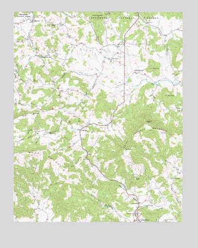
Elk Creek, VA USGS Topographic Map
Click on map above to begin viewing in our Map Viewer.

This topographic map contains these locations and features:
Feature Name Type Latitude Longitude GNIS ID View Map
Bennington MillPopulated PlaceN36.7235°W81.2290°1481633View Map
Big RidgeRidgeN36.6860°W81.2465°1487032View Map
Chestnut Hill ChurchChurchN36.6510°W81.1320°1482479View Map
Chestnut Hill School (historical)SchoolN36.6521°W81.1320°1501165View Map
Comers RockPopulated PlaceN36.7443°W81.2362°1482671View Map
Comers Rock BranchStreamN36.7240°W81.2332°1482672View Map
Comers Rock School (historical)SchoolN36.7343°W81.2395°1501168View Map
Cross Road ChurchChurchN36.7298°W81.1718°1482854View Map
Elk CreekPopulated PlaceN36.7215°W81.1770°1483265View Map
Elk Creek DistrictCivilN36.6675°W81.1759°1927312View Map
Elk Creek Elementary SchoolSchoolN36.7209°W81.1779°1501180View Map
Elk Creek Post OfficePost OfficeN36.7188°W81.1690°2780807View Map
Elk Creek Rescue SquadBuildingN36.7146°W81.1683°2086221View Map
Elk Creek Volunteer Fire DepartmentBuildingN36.7212°W81.1771°2086253View Map
Farmers BranchStreamN36.6787°W81.2332°1483376View Map
Fellowship ChurchChurchN36.7307°W81.1684°1483396View Map
Fellowship Church (historical)ChurchN36.7054°W81.2193°1501183View Map
Flag Pond BranchStreamN36.7132°W81.1837°1483430View Map
Forest ChurchChurchN36.7437°W81.1501°1483480View Map
Forest School (historical)SchoolN36.7415°W81.1451°1501187View Map
Grayson CountyCivilN36.6565°W81.2249°1501196View Map
Hollow Rock HollowValleyN36.6625°W81.1969°1484158View Map
Jumping CreekStreamN36.7104°W81.1648°1484517View Map
Little Peach Bottom CreekStreamN36.6348°W81.1562°1484954View Map
Longs GapGapN36.6793°W81.2004°1485076View Map
Low GapGapN36.6779°W81.1365°1485105View Map
Lower Elk CreekPopulated PlaceN36.7140°W81.1593°1485116View Map
Lund School (historical)SchoolN36.6451°W81.2359°1501216View Map
Maple Shade Church (historical)ChurchN36.6318°W81.1329°1501218View Map
Mount Zion ChurchChurchN36.7337°W81.2393°1485657View Map
Point Lookout MountainSummitN36.6679°W81.1670°1486309View Map
Poor KnobSummitN36.7004°W81.1359°1486340View Map
Powdermill CreekStreamN36.7140°W81.1859°1486403View Map
Reverend J W Rader Memorial BridgeBridgeN36.7110°W81.1679°1501247View Map
Roaring BranchStreamN36.6354°W81.1359°1486652View Map
Roger BranchStreamN36.6307°W81.1259°1486759View Map
Rolling Acres DairyLocaleN36.6356°W81.1761°2676014View Map
Round MountainSummitN36.7473°W81.1879°1486789View Map
Rudy School (historical)SchoolN36.7079°W81.1454°1501251View Map
Salem ChurchChurchN36.6832°W81.1929°1486888View Map
Shop BranchStreamN36.7060°W81.1601°1487211View Map
South Branch Elk CreekStreamN36.7146°W81.2470°1487387View Map
Stone CreekStreamN36.7098°W81.1620°1487598View Map
Stone School (historical)SchoolN36.7026°W81.2151°1501259View Map
Stones ChapelChurchN36.7029°W81.2151°1487607View Map
Striped RockSummitN36.6512°W81.1593°1494277View Map
Sugarcamp BranchStreamN36.6765°W81.2298°1487703View Map
The Devils HopperBasinN36.6846°W81.1512°1487822View Map
The PinnacleSummitN36.6679°W81.1673°1487844View Map
Tims KnobSummitN36.7165°W81.1468°1487926View Map
Town of IndependenceCivilN36.6254°W81.1510°2391239View Map
Turkey ForkPopulated PlaceN36.7498°W81.1581°1501265View Map
Turkey ForkStreamN36.7079°W81.1293°1488019View Map
Union ChurchChurchN36.7423°W81.2148°1488058View Map
Vaughn BranchStreamN36.7296°W81.2051°1488115View Map

Note: Coordinates in the location and feature list above are referenced to NAD83 datum.


Copyright (C) 2008-2024 Ryan Niemi / Sunset Dynamics ... All Rights Reserved