TopoQuest Logo
Do you find TopoQuest useful?
Help keep TopoQuest running and adding new maps/features by donating!
Bitcoin:  19c7KJd3qBynnjoSw5npx9KScwjBe4ifkT
Litecoin:  LXs6TkuXGGXo1vDsWCkWVdjQX94eUKd6ui
Home View Maps Find Maps Find Places Resources & Links


East Juliette, Georgia Topographic Map

USGS Map Title: East Juliette, GA
USGS Map MRC: 33083A7
DRG (GeoTIFF) Download: o33083a7.tif


Neighboring USGS Topographic Map Quads:


  Indian Springs, GA  
33083B8
 

  Berner, GA  
33083B7
 

  Hillsboro, GA  
33083B6
 

  Forsyth, GA  
33083A8
 

  East Juliette, GA  
33083A7
 

  Dames Ferry, GA  
33083A6
 

  Smarr, GA  
32083H8
 

  Bolingbroke, GA  
32083H7
 

  Macon NW, GA  
32083H6


Map MRC Location:

N34°
W84°
N34°
W83°
H8 H7 H6 H5 H4 H3 H2 H1
G8 G7 G6 G5 G4 G3 G2 G1
F8 F7 F6 F5 F4 F3 F2 F1
E8 E7 E6 E5 E4 E3 E2 E1
D8 D7 D6 D5 D4 D3 D2 D1
C8 C7 C6 C5 C4 C3 C2 C1
B8 B7 B6 B5 B4 B3 B2 B1
A8 A7 A6 A5 A4 A3 A2 A1
N33°
W84°
N33°
W83°

East Juliette, GA USGS 1:24K Topographic Map Preview:
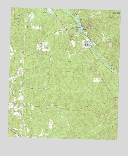
East Juliette, GA USGS Topographic Map
Click on map above to begin viewing in our Map Viewer.

This topographic map contains these locations and features:
Feature Name Type Latitude Longitude GNIS ID View Map
Berry CreekStreamN33.0865°W83.7799°311114View Map
Bethesda ChurchChurchN33.1182°W83.7607°311219View Map
Briar BranchStreamN33.1168°W83.8432°311765View Map
Bridges IslandIslandN33.1160°W83.7977°311790View Map
Browns ChapelChurchN33.0810°W83.8591°311894View Map
Chambliss CreekStreamN33.0593°W83.8644°312544View Map
Champion CreekStreamN33.1168°W83.8646°312546View Map
East JuliettePopulated PlaceN33.1087°W83.7924°355599View Map
East Juliette ChurchChurchN33.1071°W83.7832°345346View Map
Ebenezer CemeteryCemeteryN33.0439°W83.8601°343043View Map
Ebenezer ChurchChurchN33.0437°W83.8596°355621View Map
Ephesus ChurchChurchN33.0904°W83.8391°355712View Map
Friendship ChurchChurchN33.0310°W83.8210°355938View Map
Glover Ferry (historical)CrossingN33.1079°W83.7952°345351View Map
Hicks LakeReservoirN33.0213°W83.8134°340097View Map
Hicks Lake DamDamN33.0201°W83.8132°340096View Map
Hinton Shoals BridgeBridgeN33.1149°W83.8705°315462View Map
Holly Grove CemeteryCemeteryN33.0282°W83.7955°315556View Map
Holly Grove Primitive Baptist Church (historical)ChurchN33.0285°W83.8060°343058View Map
Holly Grove School (historical)SchoolN33.0285°W83.8060°343059View Map
Jerry Wadley Memorial BridgeBridgeN33.1079°W83.7952°343061View Map
JuliettePopulated PlaceN33.1074°W83.8002°332125View Map
Juliette Baptist ChurchChurchN33.1118°W83.8180°343062View Map
Juliette CemeteryCemeteryN33.1001°W83.8068°343063View Map
Juliette Junior High School (historical)SchoolN33.1076°W83.7810°345371View Map
Juliette School (historical)SchoolN33.1032°W83.8124°334708View Map
Juliette United Methodist ChurchChurchN33.0999°W83.8063°343064View Map
Little Deer CreekStreamN33.0068°W83.7843°317054View Map
Monroe County Fire Department Station 3BuildingN33.1069°W83.8000°2604799View Map
Newby-Mitchell CemeteryCemeteryN33.1015°W83.7635°334691View Map
PercalePopulated PlaceN33.0896°W83.7952°343090View Map
Rum Creek Wildlife Management AreaParkN33.0546°W83.8055°343097View Map
Saint Pauls ChurchChurchN33.0960°W83.8063°322271View Map
Saint Peters Rock CemeteryCemeteryN33.0404°W83.7542°322301View Map
Saint Peters Rock ChurchChurchN33.0654°W83.7752°322302View Map
Saint Peters Rock Church (historical)ChurchN33.0401°W83.7541°334712View Map
Scoggins CreekStreamN33.0910°W83.7799°322637View Map
Spring Hill Baptist ChurchChurchN33.0987°W83.8052°343111View Map
Standard CreekStreamN33.1210°W83.8330°329809View Map
Third BranchStreamN33.1185°W83.8005°329966View Map
Walker School (historical)SchoolN33.0268°W83.8699°343115View Map
White Oak Spring BranchStreamN33.1135°W83.8552°325179View Map
Williams LakeReservoirN33.0894°W83.8341°337425View Map
Williams Lake DamDamN33.0885°W83.8332°337424View Map
Zellner IslandIslandN33.1021°W83.7943°325660View Map

Note: Coordinates in the location and feature list above are referenced to NAD83 datum.


Copyright (C) 2008-2024 Ryan Niemi / Sunset Dynamics ... All Rights Reserved