TopoQuest Logo
Do you find TopoQuest useful?
Help keep TopoQuest running and adding new maps/features by donating!
Bitcoin:  19c7KJd3qBynnjoSw5npx9KScwjBe4ifkT
Litecoin:  LXs6TkuXGGXo1vDsWCkWVdjQX94eUKd6ui
Home View Maps Find Maps Find Places Resources & Links


Duffee, Mississippi Topographic Map

USGS Map Title: Duffee, MS
USGS Map MRC: 32088D8
DRG (GeoTIFF) Download: o32088d8.tif


Neighboring USGS Topographic Map Quads:


  Union East, MS  
32089E1
 

  Post, MS  
32088E8
 

  Center Hill, MS  
32088E7
 

  Decatur, MS  
32089D1
 

  Duffee, MS  
32088D8
 

  Collinsville, MS  
32088D7
 

  Hickory, MS  
32089C1
 

  Chunky, MS  
32088C8
 

  Meehan, MS  
32088C7


Map MRC Location:

N33°
W89°
N33°
W88°
H8 H7 H6 H5 H4 H3 H2 H1
G8 G7 G6 G5 G4 G3 G2 G1
F8 F7 F6 F5 F4 F3 F2 F1
E8 E7 E6 E5 E4 E3 E2 E1
D8 D7 D6 D5 D4 D3 D2 D1
C8 C7 C6 C5 C4 C3 C2 C1
B8 B7 B6 B5 B4 B3 B2 B1
A8 A7 A6 A5 A4 A3 A2 A1
N32°
W89°
N32°
W88°

Duffee, MS USGS 1:24K Topographic Map Preview:
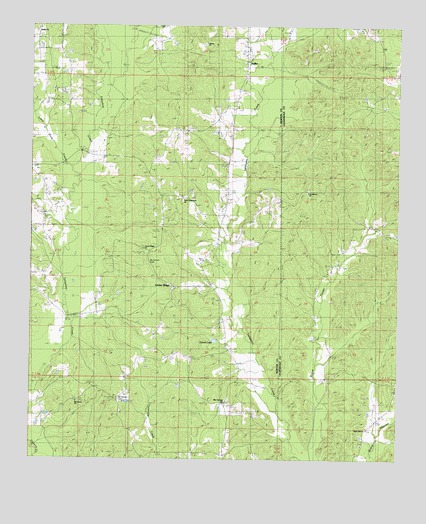
Duffee, MS USGS Topographic Map
Click on map above to begin viewing in our Map Viewer.

This topographic map contains these locations and features:
Feature Name Type Latitude Longitude GNIS ID View Map
Blackwell School (historical)SchoolN32.4699°W88.9864°689451View Map
Blue Springs ChurchChurchN32.3913°W88.9337°667325View Map
Center RidgePopulated PlaceN32.4251°W88.9514°689457View Map
Center Ridge ChurchChurchN32.4363°W88.9617°668251View Map
Center Ridge School (historical)SchoolN32.4246°W88.9509°689458View Map
Daniel LakeReservoirN32.4093°W88.9369°669096View Map
DuffeePopulated PlaceN32.4893°W88.9270°669484View Map
Duffee ChurchChurchN32.4607°W88.9595°669485View Map
Duffee ChurchChurchN32.4957°W88.9276°689474View Map
Duffee ChurchChurchN32.4982°W88.9987°689475View Map
Evergreen (historical)Populated PlaceN32.4251°W88.9389°689477View Map
Faith Tabernacle ChurchChurchN32.4504°W88.9487°689478View Map
Liberty ChurchChurchN32.4951°W88.9409°672449View Map
Little Rock CreekStreamN32.4599°W88.9870°672675View Map
Mount Carmon CemeteryCemeteryN32.4315°W88.9603°673969View Map
Mount Carmon Church (historical)ChurchN32.4326°W88.9589°689506View Map
Mount Vernon CemeteryCemeteryN32.3924°W88.9706°674289View Map
Mount Vernon ChurchChurchN32.3915°W88.9845°674299View Map
Mount Zion Church (historical)ChurchN32.3924°W88.9709°689510View Map
Nanahuma Post Office (historical)Post OfficeN32.4168°W88.9764°713028View Map
Oak Grove ChurchChurchN32.3854°W88.9673°675037View Map
Oak Grove School (historical)SchoolN32.3846°W88.9673°689516View Map
Perota (historical)Populated PlaceN32.4182°W88.9751°689520View Map
Providence ChurchChurchN32.4524°W88.9056°676379View Map
Rock Hill ChurchChurchN32.3840°W88.8848°676758View Map
Sand BranchStreamN32.4160°W88.9859°689536View Map
Spring Chapel School (historical)SchoolN32.4496°W88.9448°689540View Map
Thirteenth School (historical)SchoolN32.3757°W88.9339°689545View Map

Note: Coordinates in the location and feature list above are referenced to NAD83 datum.


Copyright (C) 2008-2024 Ryan Niemi / Sunset Dynamics ... All Rights Reserved