TopoQuest Logo
Do you find TopoQuest useful?
Help keep TopoQuest running and adding new maps/features by donating!
Bitcoin:  19c7KJd3qBynnjoSw5npx9KScwjBe4ifkT
Litecoin:  LXs6TkuXGGXo1vDsWCkWVdjQX94eUKd6ui
Home View Maps Find Maps Find Places Resources & Links


Cornerstone, Arkansas Topographic Map

USGS Map Title: Cornerstone, AR
USGS Map MRC: 34091B6
DRG (GeoTIFF) Download: o34091b6.tif


Neighboring USGS Topographic Map Quads:


  Altheimer, AR  
34091C7
 

  Humphrey SW, AR  
34091C6
 

  Lodge Corner, AR  
34091C5
 

  Moscow, AR  
34091B7
 

  Cornerstone, AR  
34091B6
 

  Reydell, AR  
34091B5
 

  Tarry, AR  
34091A7
 

  Grady, AR  
34091A6
 

  Cades, AR  
34091A5


Map MRC Location:

N35°
W92°
N35°
W91°
H8 H7 H6 H5 H4 H3 H2 H1
G8 G7 G6 G5 G4 G3 G2 G1
F8 F7 F6 F5 F4 F3 F2 F1
E8 E7 E6 E5 E4 E3 E2 E1
D8 D7 D6 D5 D4 D3 D2 D1
C8 C7 C6 C5 C4 C3 C2 C1
B8 B7 B6 B5 B4 B3 B2 B1
A8 A7 A6 A5 A4 A3 A2 A1
N34°
W92°
N34°
W91°

Cornerstone, AR USGS 1:24K Topographic Map Preview:
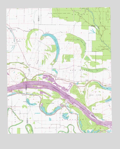
Cornerstone, AR USGS Topographic Map
Click on map above to begin viewing in our Map Viewer.

This topographic map contains these locations and features:
Feature Name Type Latitude Longitude GNIS ID View Map
Antioch Church (historical)ChurchN34.1304°W91.6876°64040View Map
Antioch School (historical)SchoolN34.1301°W91.6876°64041View Map
Bankhead Landing (historical)LocaleN34.1737°W91.7162°63894View Map
Beaver Dam SloughStreamN34.2229°W91.6371°46271View Map
Bigham BayouGutN34.2307°W91.6696°63902View Map
Brent CemeteryCemeteryN34.1562°W91.7129°46926View Map
Clements (historical)Populated PlaceN34.1768°W91.6704°60692View Map
Cooper BendBendN34.1348°W91.6401°64049View Map
Cooper IslandIslandN34.1618°W91.6460°48014View Map
Cooper PointCapeN34.1376°W91.6407°63910View Map
CornerstonePopulated PlaceN34.2304°W91.7451°48058View Map
Elam CemeteryCemeteryN34.2184°W91.6898°48834View Map
Elam Church (historical)ChurchN34.2195°W91.6899°63921View Map
ElmwoodPopulated PlaceN34.2284°W91.7207°76874View Map
EnglishPopulated PlaceN34.1768°W91.6551°57724View Map
English LakeLakeN34.1567°W91.6330°75706View Map
Eudora SchoolSchoolN34.1915°W91.6621°48923View Map
Five ForkStreamN34.2482°W91.6521°49080View Map
Galilee Church (historical)ChurchN34.1718°W91.6312°63927View Map
Garrett CemeteryCemeteryN34.1395°W91.6832°64057View Map
Goat ShedLocaleN34.1565°W91.7271°49462View Map
Grassy LakeSwampN34.1878°W91.6461°49576View Map
Greenback Ferry (historical)CrossingN34.1737°W91.7251°63931View Map
Huffs IslandIslandN34.1559°W91.6993°50396View Map
Huffs Island Public Use AreaParkN34.1598°W91.6829°77250View Map
Kimbrough (historical)Populated PlaceN34.1273°W91.6329°64064View Map
Kings BayouStreamN34.1765°W91.7304°50862View Map
Kinnlen Star ChurchChurchN34.1637°W91.7279°50877View Map
Lake FarmPopulated PlaceN34.2245°W91.7037°77431View Map
Linn (historical)Populated PlaceN34.1890°W91.7126°60691View Map
Lock and Dam Number 3DamN34.1637°W91.6779°82504View Map
Long PondGutN34.2407°W91.6587°51439View Map
McDonald LakeLakeN34.1562°W91.7243°77629View Map
Morning Star CemeteryCemeteryN34.2129°W91.7415°52198View Map
Morning Star ChurchChurchN34.2270°W91.7226°52201View Map
Mount Zion Church (historical)ChurchN34.1923°W91.6962°63960View Map
Old River LakeLakeN34.1448°W91.6979°75055View Map
Olive Branch ChurchChurchN34.1520°W91.7457°53040View Map
Pool ThreeReservoirN34.1756°W91.6920°79587View Map
RichardsonPopulated PlaceN34.2182°W91.7382°58486View Map
Rising Star Church (historical)ChurchN34.1593°W91.7279°63983View Map
Rising Star Public Use AreaParkN34.1690°W91.7368°78180View Map
Round Cypress BrakeSwampN34.2184°W91.6634°54234View Map
Round LakeLakeN34.1421°W91.6809°75107View Map
Round Lake CemeteryCemeteryN34.1448°W91.6771°64091View Map
Round Lake CutoffChannelN34.1385°W91.6497°2784717View Map
Saint Paul CemeteryCemeteryN34.1901°W91.6954°54434View Map
Saint Pauls Church (historical)ChurchN34.1893°W91.6960°63994View Map
Simpson PointCapeN34.1407°W91.6662°64094View Map
Swan LakeLakeN34.2223°W91.6966°75156View Map
Swan LakePopulated PlaceN34.1823°W91.6940°78509View Map
Swan Lake BendBendN34.1577°W91.6692°2784716View Map
SwedenPopulated PlaceN34.1932°W91.7243°57201View Map
Township of KimbroughCivilN34.1310°W91.6756°66824View Map
Township of Old RiverCivilN34.1890°W91.6504°66739View Map
Union ChurchChurchN34.1957°W91.7304°55800View Map
Wash LakeSwampN34.1975°W91.7132°56072View Map
Wynn CemeteryCemeteryN34.1259°W91.6840°56574View Map
Youngstown (historical)Populated PlaceN34.1445°W91.7065°60275View Map

Note: Coordinates in the location and feature list above are referenced to NAD83 datum.


Copyright (C) 2008-2024 Ryan Niemi / Sunset Dynamics ... All Rights Reserved