TopoQuest Logo
Do you find TopoQuest useful?
Help keep TopoQuest running and adding new maps/features by donating!
Bitcoin:  19c7KJd3qBynnjoSw5npx9KScwjBe4ifkT
Litecoin:  LXs6TkuXGGXo1vDsWCkWVdjQX94eUKd6ui
Home View Maps Find Maps Find Places Resources & Links


Harmony, Maine Topographic Map

USGS Map Title: Harmony, ME
USGS Map MRC: 44069H5
DRG (GeoTIFF) Download: o44069h5.tif


Neighboring USGS Topographic Map Quads:


  Kingsbury, ME  
45069A6
 

  Wellington, ME  
45069A5
 

  Cambridge, ME  
45069A4
 

  Athens, ME  
44069H6
 

  Harmony, ME  
44069H5
 

  Hartland, ME  
44069H4
 

  Skowhegan, ME  
44069G6
 

  Canaan, ME  
44069G5
 

  Pittsfield, ME  
44069G4


Map MRC Location:

N45°
W70°
N45°
W69°
H8 H7 H6 H5 H4 H3 H2 H1
G8 G7 G6 G5 G4 G3 G2 G1
F8 F7 F6 F5 F4 F3 F2 F1
E8 E7 E6 E5 E4 E3 E2 E1
D8 D7 D6 D5 D4 D3 D2 D1
C8 C7 C6 C5 C4 C3 C2 C1
B8 B7 B6 B5 B4 B3 B2 B1
A8 A7 A6 A5 A4 A3 A2 A1
N44°
W70°
N44°
W69°

Harmony, ME USGS 1:24K Topographic Map Preview:
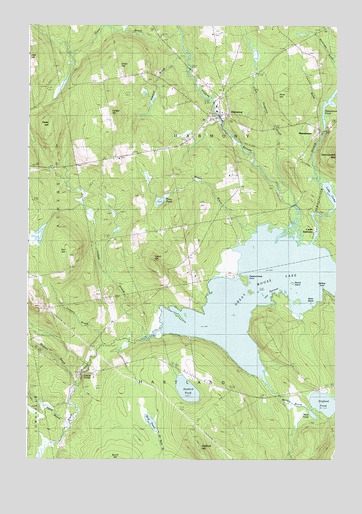
Harmony, ME USGS Topographic Map
Click on map above to begin viewing in our Map Viewer.

This topographic map contains these locations and features:
Feature Name Type Latitude Longitude GNIS ID View Map
Birch IslandIslandN44.9201°W69.5095°562304View Map
Black StreamStreamN44.9120°W69.5703°562515View Map
Bog PondLakeN44.8857°W69.5744°562690View Map
Brown BrookStreamN44.9389°W69.5359°563028View Map
Carson HillSummitN44.9749°W69.5918°563630View Map
Castle HarmonyPopulated PlaceN44.9412°W69.5084°579183View Map
Chadborne CemeteryCemeteryN44.9979°W69.5496°563783View Map
Church BrookStreamN44.9781°W69.5042°563983View Map
Corson CornerPopulated PlaceN44.8995°W69.6023°579216View Map
Fox HillSummitN44.9336°W69.6085°566510View Map
Grant BrookStreamN44.9967°W69.5623°579075View Map
Grant HillSummitN44.9884°W69.5881°567059View Map
Great Moose LakeLakeN44.9230°W69.5172°567165View Map
Halfway PointCapeN44.9242°W69.5048°567488View Map
HarmonyPopulated PlaceN44.9739°W69.5462°567654View Map
Harmony Elementary SchoolSchoolN44.9769°W69.5485°1908556View Map
Harmony Fire DepartmentBuildingN44.9828°W69.5424°2552716View Map
Harmony Post OfficePost OfficeN44.9774°W69.5474°1908557View Map
Harmony Regional Ambulance ServiceBuildingN44.9829°W69.5424°2666730View Map
Higgins BrookReservoirN44.9744°W69.5480°1774311View Map
Higgins Brook DamDamN44.9744°W69.5480°1774310View Map
Higgins StreamStreamN44.9484°W69.5173°568004View Map
Hurd HillSummitN44.9800°W69.5236°568491View Map
Joaquin BrookStreamN44.9076°W69.5926°568859View Map
Jordan CemeteryCemeteryN44.8976°W69.5521°568985View Map
Kimball BrookStreamN44.9789°W69.5734°569169View Map
Lake ComoLakeN44.9516°W69.5020°564261View Map
Ledge Island (historical)IslandN44.9342°W69.5278°579066View Map
Leighton CemeteryCemeteryN44.9809°W69.5931°569464View Map
Lemon StreamStreamN44.9098°W69.5759°569476View Map
Libby CemeteryCemeteryN44.9660°W69.5612°569524View Map
Little Ferguson BrookStreamN44.9476°W69.5150°569779View Map
Magoon BrookStreamN44.8962°W69.6048°570651View Map
MainstreamPopulated PlaceN44.9695°W69.5070°570679View Map
Mainstream Station (historical)LocaleN44.9612°W69.5153°579067View Map
Mud PondLakeN44.8881°W69.5092°571904View Map
North Road CemeteryCemeteryN44.9845°W69.5772°572404View Map
Passaconaway PointCapeN44.9259°W69.5353°573038View Map
Peeks HillSummitN44.9703°W69.6166°573129View Map
Perry PondLakeN44.9494°W69.5712°573220View Map
Round IslandIslandN44.9259°W69.5173°574474View Map
Stafford HillSummitN44.8787°W69.5550°576220View Map
Stafford PondLakeN44.8912°W69.5038°576222View Map
Starbird PondLakeN44.8952°W69.5600°576262View Map
Talbot HillSummitN44.9325°W69.5743°576641View Map
The NarrowsChannelN44.9217°W69.5267°576856View Map
Town of HarmonyCivilN44.9748°W69.5437°579051View Map
Town of HartlandCivilN44.8799°W69.5206°579050View Map
Tuttle BrookStreamN44.8851°W69.6073°577460View Map
Whitehouse BrookStreamN44.9992°W69.5937°578386View Map
Withee BrookStreamN44.8984°W69.5289°578628View Map

Note: Coordinates in the location and feature list above are referenced to NAD83 datum.


Copyright (C) 2008-2024 Ryan Niemi / Sunset Dynamics ... All Rights Reserved