TopoQuest Logo
Do you find TopoQuest useful?
Help keep TopoQuest running and adding new maps/features by donating!
Bitcoin:  19c7KJd3qBynnjoSw5npx9KScwjBe4ifkT
Litecoin:  LXs6TkuXGGXo1vDsWCkWVdjQX94eUKd6ui
Home View Maps Find Maps Find Places Resources & Links


Hartland, Maine Topographic Map

USGS Map Title: Hartland, ME
USGS Map MRC: 44069H4
DRG (GeoTIFF) Download: o44069h4.tif


Neighboring USGS Topographic Map Quads:


  Wellington, ME  
45069A5
 

  Cambridge, ME  
45069A4
 

  Dexter, ME  
45069A3
 

  Harmony, ME  
44069H5
 

  Hartland, ME  
44069H4
 

  Corinna, ME  
44069H3
 

  Canaan, ME  
44069G5
 

  Pittsfield, ME  
44069G4
 

  Newport, ME  
44069G3


Map MRC Location:

N45°
W70°
N45°
W69°
H8 H7 H6 H5 H4 H3 H2 H1
G8 G7 G6 G5 G4 G3 G2 G1
F8 F7 F6 F5 F4 F3 F2 F1
E8 E7 E6 E5 E4 E3 E2 E1
D8 D7 D6 D5 D4 D3 D2 D1
C8 C7 C6 C5 C4 C3 C2 C1
B8 B7 B6 B5 B4 B3 B2 B1
A8 A7 A6 A5 A4 A3 A2 A1
N44°
W70°
N44°
W69°

Hartland, ME USGS 1:24K Topographic Map Preview:
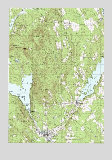
Hartland, ME USGS Topographic Map
Click on map above to begin viewing in our Map Viewer.

This topographic map contains these locations and features:
Feature Name Type Latitude Longitude GNIS ID View Map
Big Indian CampsLocaleN44.9553°W69.3759°562182View Map
Birch IslandIslandN44.9212°W69.3995°1908490View Map
Courser Memorial SchoolSchoolN44.9903°W69.3770°1908744View Map
CyrsPopulated PlaceN44.9498°W69.4731°579225View Map
Devils HeadSummitN44.9651°W69.4756°565075View Map
Dickey BrookStreamN44.9989°W69.4642°565090View Map
Goodwin BrookStreamN44.9392°W69.4698°566894View Map
Great Moose Lake DamDamN44.8849°W69.4537°1773713View Map
HartlandPopulated PlaceN44.8834°W69.4475°567712View Map
Hartland Census Designated PlaceCensusN44.8815°W69.4586°2377917View Map
Hartland Consolidated SchoolSchoolN44.8818°W69.4454°1908558View Map
Hartland First Baptist ChurchChurchN44.8853°W69.4475°1908559View Map
Hartland Methodist ChurchChurchN44.8828°W69.4467°1908561View Map
Hartland Post OfficePost OfficeN44.8824°W69.4517°2768932View Map
Hartland Public LibraryBuildingN44.8834°W69.4519°1908563View Map
Hartland Saint Albans Emergency Medical ServicesBuildingN44.8821°W69.4550°2666801View Map
Hartland Volunteer Fire DepartmentBuildingN44.8822°W69.4549°2552856View Map
Indian PondReservoirN44.9134°W69.4078°1773724View Map
Indian PondReservoirN44.9367°W69.3854°568604View Map
Indian Stream ReservoirReservoirN44.9101°W69.4078°1774250View Map
Latty PointCapeN44.9206°W69.4956°569398View Map
Lower DamDamN44.8826°W69.4493°1774173View Map
Lower DamDamN44.9100°W69.4087°1774249View Map
Lyshornes BrookStreamN44.9798°W69.4981°570604View Map
Mainstream MountainSummitN44.9649°W69.4953°570680View Map
Mainstream PondLakeN44.9854°W69.4955°570681View Map
Maloon CemeteryCemeteryN44.9409°W69.4052°2737033View Map
Meloon BrookStreamN44.9298°W69.3973°571132View Map
Mill PondReservoirN44.8834°W69.4478°1774174View Map
Northeast CoveBayN44.9339°W69.4789°572438View Map
Packard PointCapeN44.9264°W69.4809°572912View Map
Pond Road SchoolSchoolN44.8939°W69.4492°573613View Map
Pratt BrookStreamN44.8756°W69.4398°573752View Map
Railbridge BrookStreamN44.9876°W69.4995°573974View Map
Ray BrookStreamN44.8845°W69.4353°574056View Map
Rowell HillSummitN44.9021°W69.4830°574556View Map
Saint AlbansPopulated PlaceN44.9101°W69.4100°574683View Map
Saint Albans Consolidated SchoolSchoolN44.9042°W69.4207°1908667View Map
Saint Albans MountainSummitN44.9755°W69.4583°574684View Map
Saint Albans Union ChurchChurchN44.9109°W69.4106°1908668View Map
Saint Albans Volunteer Fire DepartmentBuildingN44.9119°W69.4092°2552780View Map
Sandbar PointCapeN44.9101°W69.4770°574860View Map
Somerset Valley Middle SchoolSchoolN44.8876°W69.4450°1908560View Map
StrongholdPopulated PlaceN44.9167°W69.4706°579748View Map
The PinnaclesPillarN44.9273°W69.4503°576900View Map
Three Pine IslandIslandN44.9178°W69.4825°577058View Map
Todds CornerPopulated PlaceN44.9867°W69.4250°578213View Map
Torry IslandIslandN44.9253°W69.4856°577210View Map
Town of Saint AlbansCivilN44.9319°W69.3922°582707View Map
Two Pine IslandIslandN44.9198°W69.4839°577507View Map
Upper DamDamN44.9128°W69.4089°1773723View Map
Village CemeteryCemeteryN44.8841°W69.4558°2737045View Map
Village CemeteryCemeteryN44.9054°W69.4113°2727598View Map
Watson CemeteryCemeteryN44.9724°W69.4244°2727608View Map
West Ripley CemeteryCemeteryN44.9868°W69.4319°1908737View Map
Wild Goose ClubLocaleN44.9295°W69.4689°581612View Map
WildwoodPopulated PlaceN44.9059°W69.4642°579838View Map
Wing CemeteryCemeteryN44.9577°W69.4485°578580View Map

Note: Coordinates in the location and feature list above are referenced to NAD83 datum.


Copyright (C) 2008-2024 Ryan Niemi / Sunset Dynamics ... All Rights Reserved