TopoQuest Logo
Do you find TopoQuest useful?
Help keep TopoQuest running and adding new maps/features by donating!
Bitcoin:  19c7KJd3qBynnjoSw5npx9KScwjBe4ifkT
Litecoin:  LXs6TkuXGGXo1vDsWCkWVdjQX94eUKd6ui
Home View Maps Find Maps Find Places Resources & Links


Burgess, Virginia Topographic Map

USGS Map Title: Burgess, VA
USGS Map MRC: 37076H3
DRG (GeoTIFF) Download: o37076h3.tif


Neighboring USGS Topographic Map Quads:


  Saint George Island, MD  
38076A4
 

  Point Lookout, MD  
38076A3
 

  Chesapeake Bay 3 (All Water), MD  
38076A2
 

  Heathsville, VA  
37076H4
 

  Burgess, VA  
37076H3
 

  Smith Point, VA  
37076H2
 

  Lancaster, VA  
37076G4
 

  Reedville, VA  
37076G3
 

  East of Reedville, VA  
37076G2


Map MRC Location:

N38°
W77°
N38°
W76°
H8 H7 H6 H5 H4 H3 H2 H1
G8 G7 G6 G5 G4 G3 G2 G1
F8 F7 F6 F5 F4 F3 F2 F1
E8 E7 E6 E5 E4 E3 E2 E1
D8 D7 D6 D5 D4 D3 D2 D1
C8 C7 C6 C5 C4 C3 C2 C1
B8 B7 B6 B5 B4 B3 B2 B1
A8 A7 A6 A5 A4 A3 A2 A1
N37°
W77°
N37°
W76°

Burgess, VA USGS 1:24K Topographic Map Preview:
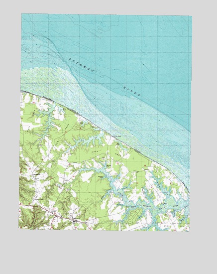
Burgess, VA USGS Topographic Map
Click on map above to begin viewing in our Map Viewer.

This topographic map contains these locations and features:
Feature Name Type Latitude Longitude GNIS ID View Map
Afton ChurchChurchN37.9093°W76.2897°1462376View Map
Back CreekStreamN37.8865°W76.2833°1462650View Map
Black PondLakeN37.9337°W76.3187°1463497View Map
Blundon CornerPopulated PlaceN37.8924°W76.3633°1492600View Map
Bridge CreekStreamN37.8832°W76.2766°1463810View Map
Bridge NeckCapeN37.8782°W76.2608°1463812View Map
Bridgemans Back CreekStreamN37.8926°W76.2783°1463814View Map
BurgessPopulated PlaceN37.8832°W76.3477°1492674View Map
Burgess Post OfficePost OfficeN37.8826°W76.3457°2767203View Map
Cod CreekStreamN37.8876°W76.2941°1465049View Map
Condit PondLakeN37.9373°W76.3275°1465166View Map
Cordreys BeachBeachN37.9543°W76.3738°1501619View Map
Cubitt CreekStreamN37.9490°W76.3499°1501620View Map
Davis Mill (historical)LocaleN37.9021°W76.3377°1760751View Map
Davis Mill RunStreamN37.9021°W76.3377°1760753View Map
Davis Millpond (historical)ReservoirN37.9021°W76.3377°1760752View Map
Donlins CoveBayN37.9285°W76.3127°1760758View Map
EdwardsvillePopulated PlaceN37.9065°W76.3652°1466190View Map
Edwardsville School (historical)SchoolN37.8901°W76.3613°1760762View Map
Ellyson CreekStreamN37.8951°W76.2655°1466255View Map
Fairfields CemeteryCemeteryN37.9032°W76.3630°1466391View Map
Fairfields ChurchChurchN37.8826°W76.3436°1466392View Map
Fairfields ChurchChurchN37.8851°W76.3513°1466393View Map
Fairfields SchoolSchoolN37.8801°W76.3344°1466394View Map
Federhart-Ophelia AirportAirportN37.9053°W76.2906°1480239View Map
Flag PondLakeN37.9254°W76.3013°1466630View Map
Flood PointCapeN37.8899°W76.2897°1466729View Map
FollyPopulated PlaceN37.8796°W76.3277°1492950View Map
Galilee ChurchChurchN37.8971°W76.3627°1466956View Map
Gills PointCapeN37.8832°W76.2758°1760778View Map
Ginny BeachBeachN37.9010°W76.2538°1501625View Map
GonyonPopulated PlaceN37.9037°W76.3386°1493011View Map
Grays School (historical)SchoolN37.9062°W76.3711°1760781View Map
Greenfield PointCapeN37.8890°W76.2933°1467501View Map
Hack CreekStreamN37.9332°W76.3138°1501626View Map
Hack NeckCapeN37.9212°W76.3111°1467622View Map
Hack Neck School (historical)SchoolN37.9126°W76.2966°1760785View Map
Hacks Neck LandingLocaleN37.9299°W76.3077°1760786View Map
Hansons CoveBayN37.9060°W76.3124°1467722View Map
Horse PondLakeN37.8835°W76.2688°1468272View Map
Hull NeckCapeN37.9385°W76.3666°1468371View Map
Hygeia School (historical)SchoolN37.8801°W76.3377°1760802View Map
Jett AirparkAirportN37.9006°W76.3594°1498659View Map
Jetts StorePopulated PlaceN37.9168°W76.3224°1760805View Map
KayanPopulated PlaceN37.8910°W76.2699°1477456View Map
King PointCapeN37.8882°W76.2727°1469010View Map
Little Wicomico LandingLocaleN37.8910°W76.2697°1760814View Map
Lowes PondLakeN37.9456°W76.3447°1469923View Map
Marshalls BeachBeachN37.9507°W76.3555°1501631View Map
Mob NeckCapeN37.9299°W76.3436°1470648View Map
Northumberland Volunteer Rescue Squad Station 2BuildingN37.8901°W76.3480°2660632View Map
OpheliaPopulated PlaceN37.9101°W76.2836°1493378View Map
Ophelia Post OfficePost OfficeN37.9104°W76.2829°2766484View Map
Peachtree PointCapeN37.8876°W76.2788°1472149View Map
Potomac RiverStreamN37.9389°W76.2528°597915View Map
Sawmill CoveBayN37.9126°W76.3119°1474073View Map
Serenity Farm AirportAirportN37.9346°W76.3471°2675644View Map
Sharps CreekStreamN37.8874°W76.2605°1474453View Map
Shiloh ChurchChurchN37.8801°W76.3336°1474519View Map
Sloop CreekStreamN37.8899°W76.2977°1474698View Map
Slough CreekStreamN37.8849°W76.2533°1474702View Map
Smith Point MarinaHarborN37.8836°W76.2510°2520117View Map
Spences CreekStreamN37.8985°W76.3002°1474943View Map
Spring CoveStreamN37.9037°W76.3024°1474983View Map
SunnybankPopulated PlaceN37.8862°W76.2672°1493675View Map
Sunnybank FerryCrossingN37.8887°W76.2680°1760852View Map
Vir-Mar BeachPopulated PlaceN37.9293°W76.3058°1493742View Map
Walkers StoreLocaleN37.8812°W76.3361°1476251View Map
Willis CreekStreamN37.8987°W76.3058°1476778View Map

Note: Coordinates in the location and feature list above are referenced to NAD83 datum.


Copyright (C) 2008-2024 Ryan Niemi / Sunset Dynamics ... All Rights Reserved