TopoQuest Logo
Do you find TopoQuest useful?
Help keep TopoQuest running and adding new maps/features by donating!
Bitcoin:  19c7KJd3qBynnjoSw5npx9KScwjBe4ifkT
Litecoin:  LXs6TkuXGGXo1vDsWCkWVdjQX94eUKd6ui
Home View Maps Find Maps Find Places Resources & Links


Heathsville, Virginia Topographic Map

USGS Map Title: Heathsville, VA
USGS Map MRC: 37076H4
DRG (GeoTIFF) Download: o37076h4.tif


Neighboring USGS Topographic Map Quads:


  Kinsale, VA  
38076A5
 

  Saint George Island, MD  
38076A4
 

  Point Lookout, MD  
38076A3
 

  Lottsburg, VA  
37076H5
 

  Heathsville, VA  
37076H4
 

  Burgess, VA  
37076H3
 

  Lively, VA  
37076G5
 

  Lancaster, VA  
37076G4
 

  Reedville, VA  
37076G3


Map MRC Location:

N38°
W77°
N38°
W76°
H8 H7 H6 H5 H4 H3 H2 H1
G8 G7 G6 G5 G4 G3 G2 G1
F8 F7 F6 F5 F4 F3 F2 F1
E8 E7 E6 E5 E4 E3 E2 E1
D8 D7 D6 D5 D4 D3 D2 D1
C8 C7 C6 C5 C4 C3 C2 C1
B8 B7 B6 B5 B4 B3 B2 B1
A8 A7 A6 A5 A4 A3 A2 A1
N37°
W77°
N37°
W76°

Heathsville, VA USGS 1:24K Topographic Map Preview:
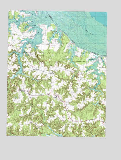
Heathsville, VA USGS Topographic Map
Click on map above to begin viewing in our Map Viewer.

This topographic map contains these locations and features:
Feature Name Type Latitude Longitude GNIS ID View Map
AvalonPopulated PlaceN37.9068°W76.4238°1477085View Map
Avalon School (historical)SchoolN37.9099°W76.4277°1760717View Map
Bay Quarter NeckCapeN37.9660°W76.4261°1462837View Map
Boathouse PondLakeN37.9637°W76.4641°1463618View Map
Brents LandingLocaleN37.9237°W76.3966°1495295View Map
Bridgeman CreekStreamN37.9532°W76.3888°1463813View Map
Bryant CornerPopulated PlaceN37.8832°W76.4588°1477151View Map
Bryants CornerLocaleN37.9651°W76.4966°1760726View Map
BundickPopulated PlaceN37.9607°W76.4872°1495333View Map
Bush MillLocaleN37.8774°W76.4947°1760728View Map
Central High SchoolSchoolN37.9146°W76.4372°1464695View Map
ClaravillePopulated PlaceN37.9174°W76.4455°1464930View Map
Clark MillpondReservoirN37.9311°W76.4641°1464941View Map
Clarkes MilldamDamN37.9324°W76.4675°1490481View Map
Clarks Mill (historical)LocaleN37.9329°W76.4672°1760735View Map
CoanPopulated PlaceN37.9585°W76.4802°1495403View Map
Coan Hall School (historical)SchoolN37.9671°W76.4483°1760737View Map
Coan Mill StreamStreamN37.9382°W76.4872°1465018View Map
Coan RiverStreamN37.9874°W76.4675°1465019View Map
Coan River MarinaHarborN37.9822°W76.4710°2520089View Map
Coan-Bundicks Ferry (historical)CrossingN37.9587°W76.4813°1760740View Map
Cod CreekStreamN37.9818°W76.4355°1465050View Map
Corbin PondLakeN37.9584°W76.4031°1465245View Map
Corinth ChurchChurchN37.9279°W76.4094°1760742View Map
Corinth School (historical)SchoolN37.9265°W76.4099°1760743View Map
CowartPopulated PlaceN37.9954°W76.4719°1495433View Map
Cowarts PointCapeN37.9940°W76.4719°1760745View Map
Crabbe MillPopulated PlaceN37.8876°W76.4502°1495434View Map
Crabbe Mill StreamStreamN37.8910°W76.4522°1465375View Map
District 2CivilN37.9272°W76.4707°1927207View Map
Downings CornerPopulated PlaceN37.8904°W76.3797°1495478View Map
Downings Mill (historical)LocaleN37.9374°W76.4144°1760759View Map
Downings MillpondReservoirN37.9350°W76.4165°1465929View Map
Fleets CoveBayN37.9387°W76.3913°1466687View Map
Floyds CoveBayN37.9385°W76.3791°1466741View Map
Forrest LandingLocaleN37.9412°W76.4841°1495555View Map
Fountain CoveBayN37.9432°W76.3966°1466804View Map
Fountain GateLocaleN37.9462°W76.4038°1466805View Map
Glebe CreekStreamN37.9887°W76.4988°1467143View Map
Hamlins CornerPopulated PlaceN37.9415°W76.4608°1477390View Map
Hawk Nest PointCapeN37.9535°W76.4850°1467841View Map
Headly CoveBayN37.9579°W76.4766°1467887View Map
HeathsvillePopulated PlaceN37.9176°W76.4722°1498490View Map
Heathsville Airport (historical)AirportN37.9451°W76.4572°1498696View Map
Heathsville Census Designated PlaceCensusN37.9200°W76.4785°2629026View Map
Heathsville Post OfficePost OfficeN37.9168°W76.4722°2767226View Map
Highland PointCapeN37.9593°W76.4797°1760793View Map
Honest PointCapeN37.9885°W76.4713°1468206View Map
Horse HeadPopulated PlaceN37.8921°W76.4188°1495716View Map
Horse Head School (historical)SchoolN37.8904°W76.4086°1760796View Map
Hull CreekStreamN37.9565°W76.3816°1468370View Map
Killneck CreekStreamN37.9857°W76.4722°1468994View Map
Kingscote CreekStreamN37.9949°W76.4680°1469024View Map
Kirkland CampgroundLocaleN37.8999°W76.4858°1469040View Map
LakePopulated PlaceN37.9743°W76.4697°1495805View Map
LewisettaPopulated PlaceN37.9979°W76.4627°1495837View Map
Lewisetta MarinaHarborN37.9959°W76.4648°2520109View Map
Luttrels CornerPopulated PlaceN37.9337°W76.4069°1477506View Map
Macedonia ChurchChurchN37.9012°W76.4241°1469976View Map
Martins Corner School (historical)SchoolN37.9454°W76.4455°1760820View Map
Mid - County Volunteer Rescue SquadBuildingN37.9138°W76.4540°2331779View Map
Mid County Rescue SquadBuildingN37.9148°W76.4556°2075290View Map
Middletons CornerPopulated PlaceN37.9454°W76.4452°1477538View Map
Mill CreekStreamN37.9565°W76.4836°1470510View Map
Neuman NeckCapeN37.9510°W76.4058°1471382View Map
NokomisPopulated PlaceN37.9443°W76.4800°1496011View Map
Northumberland County Sheriff's OfficeBuildingN37.9172°W76.4743°2331983View Map
Northumberland Elementary SchoolSchoolN37.9071°W76.4405°2465274View Map
Northumberland High SchoolSchoolN37.9128°W76.4384°1471665View Map
Northumberland Middle SchoolSchoolN37.9135°W76.4382°2464997View Map
Northumberland Public LibraryBuildingN37.9156°W76.4693°2519919View Map
Oakland School (historical)SchoolN37.8910°W76.3816°1760831View Map
Popes PointCapeN37.9551°W76.4855°1472631View Map
Poplar Farm School (historical)SchoolN37.9165°W76.4447°1760834View Map
Presley CreekStreamN37.9676°W76.4177°1472774View Map
Pumpkin HillLocaleN37.8793°W76.3761°1760836View Map
Roger PointCapeN37.9565°W76.3822°1760841View Map
Rogers CreekStreamN37.9546°W76.3811°1473506View Map
Rowes LandingLocaleN37.9362°W76.4822°1496178View Map
Saint Stephen's Anglican ChurchChurchN37.9199°W76.4736°1473914View Map
Sissons CornerPopulated PlaceN37.9374°W76.4455°1477758View Map
Sissons School (historical)SchoolN37.9396°W76.4541°1760846View Map
Smithland ChurchChurchN37.9315°W76.4444°1474782View Map
Spring CoveBayN37.9335°W76.3872°1474984View Map
Stevens PointCapeN37.9832°W76.4691°1475125View Map
Stubbins School (historical)SchoolN37.8918°W76.4311°1760851View Map
Sydnors Mill (historical)LocaleN37.9096°W76.3861°1760853View Map
Sydnors Mill CreekStreamN37.9087°W76.3908°1475411View Map
Sydnors MillpondReservoirN37.9083°W76.3866°1475412View Map
Sydnors Millpond DamDamN37.9107°W76.3844°1490483View Map
The GlebeBayN37.9901°W76.4844°1475577View Map
Virginia Marine Police - Northern Area OfficeBuildingN37.9207°W76.4794°2767141View Map
Walnut PointCapeN37.9851°W76.4644°1476288View Map
Walnut Point (historical)Populated PlaceN37.9849°W76.4636°1760857View Map
Williams CornerPopulated PlaceN37.8885°W76.4666°1477881View Map

Note: Coordinates in the location and feature list above are referenced to NAD83 datum.


Copyright (C) 2008-2024 Ryan Niemi / Sunset Dynamics ... All Rights Reserved