TopoQuest Logo
Do you find TopoQuest useful?
Help keep TopoQuest running and adding new maps/features by donating!
Bitcoin:  19c7KJd3qBynnjoSw5npx9KScwjBe4ifkT
Litecoin:  LXs6TkuXGGXo1vDsWCkWVdjQX94eUKd6ui
Home View Maps Find Maps Find Places Resources & Links


Lancaster, Virginia Topographic Map

USGS Map Title: Lancaster, VA
USGS Map MRC: 37076G4
DRG (GeoTIFF) Download: o37076g4.tif


Neighboring USGS Topographic Map Quads:


  Lottsburg, VA  
37076H5
 

  Heathsville, VA  
37076H4
 

  Burgess, VA  
37076H3
 

  Lively, VA  
37076G5
 

  Lancaster, VA  
37076G4
 

  Reedville, VA  
37076G3
 

  Urbanna, VA  
37076F5
 

  Irvington, VA  
37076F4
 

  Fleets Bay, VA  
37076F3


Map MRC Location:

N38°
W77°
N38°
W76°
H8 H7 H6 H5 H4 H3 H2 H1
G8 G7 G6 G5 G4 G3 G2 G1
F8 F7 F6 F5 F4 F3 F2 F1
E8 E7 E6 E5 E4 E3 E2 E1
D8 D7 D6 D5 D4 D3 D2 D1
C8 C7 C6 C5 C4 C3 C2 C1
B8 B7 B6 B5 B4 B3 B2 B1
A8 A7 A6 A5 A4 A3 A2 A1
N37°
W77°
N37°
W76°

Lancaster, VA USGS 1:24K Topographic Map Preview:
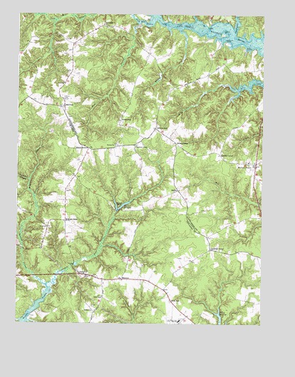
Lancaster, VA USGS Topographic Map
Click on map above to begin viewing in our Map Viewer.

This topographic map contains these locations and features:
Feature Name Type Latitude Longitude GNIS ID View Map
Beanes CornersLocaleN37.8210°W76.4633°1462867View Map
Beanes Mill (historical)LocaleN37.8404°W76.4572°1760720View Map
Belwood SwampStreamN37.7657°W76.4850°1463068View Map
Betz LandingLocaleN37.8721°W76.4322°1495263View Map
Blackwells CreekStreamN37.8676°W76.3891°1463540View Map
Booker T Washington School (historical)SchoolN37.8254°W76.4330°1778992View Map
Broad NeckCapeN37.7976°W76.4474°1463846View Map
Brook ValePopulated PlaceN37.7593°W76.4208°1495303View Map
Brook Vale High SchoolSchoolN37.7512°W76.4166°1463876View Map
Browns CornerPopulated PlaceN37.8232°W76.4186°1477147View Map
Browns StorePopulated PlaceN37.8290°W76.4288°1463935View Map
Bush Mill StreamStreamN37.8735°W76.4305°1464159View Map
Cabin SwampSwampN37.7960°W76.4486°1778996View Map
Callahan SwampStreamN37.8076°W76.4936°1464257View Map
Camp KittamaqundLocaleN37.8704°W76.3844°1464337View Map
Cedar PointCapeN37.8696°W76.4030°1464643View Map
Cedar Point LandingLocaleN37.8710°W76.4024°1760731View Map
Chestnut GrovePopulated PlaceN37.8224°W76.4394°1464808View Map
Chestnut Grove School (historical)SchoolN37.8224°W76.4405°1778998View Map
Cooper LandingLocaleN37.8715°W76.4186°1495422View Map
Cooper LandingLocaleN37.8615°W76.3841°1495423View Map
Davis Mill (historical)LocaleN37.7960°W76.4497°1779007View Map
Davis MillpondReservoirN37.7977°W76.4461°1465654View Map
Deep LandingLocaleN37.8710°W76.4377°1495463View Map
District 2CivilN37.7778°W76.4771°1952578View Map
District 3CivilN37.8161°W76.4005°1927228View Map
First Baptist ChurchChurchN37.8704°W76.4563°1760768View Map
GeorgetownPopulated PlaceN37.8318°W76.4463°1467047View Map
Hardins CornerPopulated PlaceN37.8187°W76.3963°1467734View Map
Head River BranchStreamN37.8715°W76.4369°1467885View Map
HowlandPopulated PlaceN37.8710°W76.4552°1477428View Map
Howland Chapel School (historical)SchoolN37.8707°W76.4558°1760797View Map
Indian PointCapeN37.8707°W76.4236°1468479View Map
Indian Point LandingLocaleN37.8704°W76.4247°1760803View Map
Island PointCapeN37.8685°W76.3949°1468539View Map
Knight RunStreamN37.8690°W76.4166°1469066View Map
LancasterPopulated PlaceN37.7699°W76.4663°1498502View Map
Lancaster Census Designated PlaceCensusN37.7675°W76.4548°2629030View Map
Lancaster County Emergency Medical ServicesBuildingN37.7702°W76.4655°2331785View Map
Lancaster County Sheriff's OfficeBuildingN37.7711°W76.4654°2331944View Map
Lancaster County Sheriff's OfficeBuildingN37.7700°W76.4657°2086167View Map
Lancaster Court House Historic DistrictParkN37.7701°W76.4647°1779018View Map
Lancaster High SchoolSchoolN37.7693°W76.4567°2465035View Map
Lancaster Post OfficePost OfficeN37.7673°W76.4523°2767230View Map
Lancaster Primary SchoolSchoolN37.7513°W76.4165°2465185View Map
Lankford CornerPopulated PlaceN37.7804°W76.4011°1469133View Map
Mantua District (historical)CivilN37.7693°W76.4622°1927387View Map
McMahon SwampStreamN37.7815°W76.4972°1470278View Map
McNeals CornerPopulated PlaceN37.7918°W76.4750°1477527View Map
MilestonePopulated PlaceN37.7682°W76.4463°1477542View Map
MiskimonPopulated PlaceN37.8379°W76.4761°1470629View Map
Miskimon Lookout TowerLocaleN37.8410°W76.4766°1760823View Map
Mooreland Church (historical)ChurchN37.8507°W76.4024°1760825View Map
Morning Star ChurchChurchN37.8221°W76.4483°1470745View Map
Mount Knoddy SwampSwampN37.7816°W76.4566°1779027View Map
New Lancaster SchoolSchoolN37.7821°W76.4741°1779030View Map
NewtownPopulated PlaceN37.7890°W76.4844°1471528View Map
Northumberland CountyCivilN37.8547°W76.3795°1480152View Map
Oak GrovePopulated PlaceN37.8421°W76.4236°1478022View Map
Providence ChurchChurchN37.8474°W76.4761°1472832View Map
ReginaPopulated PlaceN37.8040°W76.4174°1473130View Map
RichtownPopulated PlaceN37.7549°W76.4602°1477682View Map
Sampsons WharfLocaleN37.8646°W76.3944°1473983View Map
Smyrna Church (historical)ChurchN37.8410°W76.4783°1760848View Map
Trinity Episcopal ChurchChurchN37.7693°W76.4625°1779043View Map
Twin Branch MilldamDamN37.7951°W76.4480°1490235View Map
Twin Branch MillpondReservoirN37.7951°W76.4480°1490236View Map
White MarshSwampN37.7587°W76.4033°1779046View Map
White Marsh Campground (historical)LocaleN37.7590°W76.4208°1779047View Map
White Marsh ChurchChurchN37.7590°W76.4205°1779048View Map
Wicomico ChurchPopulated PlaceN37.8151°W76.3777°1476702View Map
Wicomico Church Post OfficePost OfficeN37.8145°W76.3785°2767275View Map
Wicomico School (historical)SchoolN37.8154°W76.3822°1760863View Map
Willie ChapelChurchN37.7607°W76.4558°1476773View Map
Willie Chapel CemeteryCemeteryN37.7610°W76.4563°1779050View Map

Note: Coordinates in the location and feature list above are referenced to NAD83 datum.


Copyright (C) 2008-2024 Ryan Niemi / Sunset Dynamics ... All Rights Reserved