TopoQuest Logo
Do you find TopoQuest useful?
Help keep TopoQuest running and adding new maps/features by donating!
Bitcoin:  19c7KJd3qBynnjoSw5npx9KScwjBe4ifkT
Litecoin:  LXs6TkuXGGXo1vDsWCkWVdjQX94eUKd6ui
Home View Maps Find Maps Find Places Resources & Links


Lake Anna West, Virginia Topographic Map

USGS Map Title: Lake Anna West, VA
USGS Map MRC: 38077A7
DRG (GeoTIFF) Download: o38077a7.tif


Neighboring USGS Topographic Map Quads:


  Lahore, VA  
38077B8
 

  Belmont, VA  
38077B7
 

  Brokenburg, VA  
38077B6
 

  Mineral, VA  
38077A8
 

  Lake Anna West, VA  
38077A7
 

  Lake Anna East, VA  
38077A6
 

  Pendleton, VA  
37077H8
 

  Buckner, VA  
37077H7
 

  Beaverdam, VA  
37077H6


Map MRC Location:

N39°
W78°
N39°
W77°
H8 H7 H6 H5 H4 H3 H2 H1
G8 G7 G6 G5 G4 G3 G2 G1
F8 F7 F6 F5 F4 F3 F2 F1
E8 E7 E6 E5 E4 E3 E2 E1
D8 D7 D6 D5 D4 D3 D2 D1
C8 C7 C6 C5 C4 C3 C2 C1
B8 B7 B6 B5 B4 B3 B2 B1
A8 A7 A6 A5 A4 A3 A2 A1
N38°
W78°
N38°
W77°

Lake Anna West, VA USGS 1:24K Topographic Map Preview:
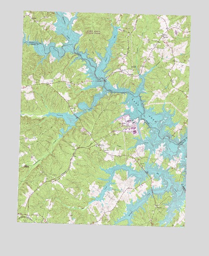
Lake Anna West, VA USGS Topographic Map
Click on map above to begin viewing in our Map Viewer.

This topographic map contains these locations and features:
Feature Name Type Latitude Longitude GNIS ID View Map
Andrews TavernBuildingN38.0987°W77.7608°1740256View Map
Barleys IslandIslandN38.0246°W77.7650°1748929View Map
Beaver CreekStreamN38.0268°W77.8067°1748932View Map
Bethel Christian Church CemeteryCemeteryN38.1093°W77.7742°1740259View Map
Bethel ChurchChurchN38.1090°W77.7744°1463198View Map
Bills IslandIslandN38.0151°W77.8164°1748933View Map
Boggs CreekStreamN38.0574°W77.7714°1740262View Map
Boggs PointCapeN38.0690°W77.7805°1740263View Map
Bohemian BayBayN38.1021°W77.8272°1740261View Map
Boxley PointCapeN38.0935°W77.8261°1748935View Map
Brumleys PointCapeN38.0782°W77.7908°1740266View Map
Busbees IslandIslandN38.0229°W77.7605°1748938View Map
Busbees PointCapeN38.0193°W77.7589°1748939View Map
Caton South HeliportAirportN38.0457°W77.7814°1498750View Map
CentrevillePopulated PlaceN38.0476°W77.8169°1477223View Map
Chisholms PointCapeN38.0260°W77.7683°1748942View Map
Christmas Tree PointCapeN38.0185°W77.7758°1748943View Map
Colling PointCapeN38.0879°W77.8122°1740270View Map
Contrary CreekStreamN38.0787°W77.8119°1465179View Map
Dicks IslandIslandN38.0132°W77.7544°1748946View Map
Douglas CreekStreamN38.0876°W77.7850°1465911View Map
Duerson PointCapeN38.0440°W77.7533°1748947View Map
Dukes CreekStreamN38.0526°W77.7505°1740274View Map
Edgewood ChurchChurchN38.0682°W77.8378°1466179View Map
Elk CreekStreamN38.0229°W77.7514°1466213View Map
Elk Creek ChurchChurchN38.0357°W77.7839°1466217View Map
Fishers PointCapeN38.1099°W77.8186°1740278View Map
Five Pound PointCapeN38.0190°W77.8130°1748948View Map
Freshwater CreekStreamN38.0582°W77.8367°1466887View Map
GlenoraPopulated PlaceN38.0887°W77.7942°1495596View Map
Good Hope Baptist ChurchChurchN38.1126°W77.7694°1467210View Map
Good Hope Baptist Church CemeteryCemeteryN38.1127°W77.7692°1740281View Map
Goodwins PointCapeN38.1076°W77.8408°1740282View Map
Green Bottle HillSummitN38.0121°W77.7797°1748949View Map
Hackney CreekStreamN38.0762°W77.7908°1748950View Map
Hailey Mill Dam (historical)DamN38.1174°W77.8078°1740284View Map
Hairfield BranchStreamN38.0785°W77.8017°1740285View Map
Harlow PointCapeN38.0979°W77.8494°1748951View Map
Harlows CreekStreamN38.1001°W77.8575°1748952View Map
Harris (historical)Populated PlaceN38.0271°W77.7650°1494690View Map
Harris PointCapeN38.0501°W77.7664°1748953View Map
Harris Post Office (historical)Post OfficeN38.0271°W77.7650°1759815View Map
HolladayPopulated PlaceN38.1204°W77.8689°1495701View Map
Ivas CovoeBayN38.0690°W77.7778°1740295View Map
Jetts IslandIslandN38.1162°W77.8411°1740296View Map
Joeys CreekStreamN38.0790°W77.7869°1740297View Map
Johnsons PointCapeN38.0510°W77.7555°1740299View Map
Lacy MillpondLakeN38.0924°W77.7889°1469090View Map
Lake AnnaReservoirN38.0612°W77.8345°1501942View Map
Lake Anna MarinaLocaleN38.0799°W77.7839°1740301View Map
Lake Anna State ParkParkN38.1154°W77.8233°1740302View Map
Laurel Hill CemeteryCemeteryN38.0431°W77.8108°1748955View Map
Laurel Hill ChurchChurchN38.0437°W77.8119°1469189View Map
Marshall CreekStreamN38.0987°W77.8311°1748956View Map
Millpond CreekStreamN38.0221°W77.7655°1470579View Map
Mitchell CreekStreamN38.0832°W77.8136°1748958View Map
Mitchells PointCapeN38.0776°W77.8150°1748959View Map
Morris PointCapeN38.1124°W77.8492°1740307View Map
Moses PointCapeN38.0340°W77.7711°1748960View Map
No Trespassing PointCapeN38.0326°W77.8019°1748961View Map
North Anna Nuclear Power PlantLocaleN38.0608°W77.7911°1491207View Map
Pamunkey CreekStreamN38.1062°W77.8375°1472035View Map
Pigeon RunStreamN38.0918°W77.8155°1472292View Map
Plum TreePopulated PlaceN38.0126°W77.7719°1477632View Map
Plumtree CoveBayN38.0057°W77.7644°1748962View Map
Rawlins PointCapeN38.0585°W77.7664°1740311View Map
Richards GutStreamN38.0104°W77.7880°1748965View Map
Rock IslandIslandN38.0301°W77.7900°1748967View Map
Rocky Branch MarinaLocaleN38.0918°W77.7800°1740314View Map
Rose Valley IslandIslandN38.1029°W77.8569°1740315View Map
Scerks CreekStreamN38.1062°W77.8739°1748968View Map
Scotts BranchStreamN38.1065°W77.8739°1740317View Map
Seay PointCapeN38.0807°W77.8039°1740318View Map
Sedges CreekStreamN38.0526°W77.7705°1474155View Map
Shaffers CoveBayN38.0910°W77.8108°1740320View Map
Showboat CreekStreamN38.0307°W77.8053°1748969View Map
Showman IslandIslandN38.0351°W77.7997°1748970View Map
Smiths PointCapeN38.0518°W77.7608°1740322View Map
Sturgeon CreekStreamN38.0779°W77.7875°1475270View Map
Sturgeon Creek MarinaLocaleN38.0896°W77.7844°1740323View Map
The RockCapeN38.0151°W77.8175°1748972View Map
Thurman IslandIslandN38.0618°W77.7697°1740326View Map
Tommys BranchStreamN38.1149°W77.8453°1740327View Map
Toms IslandIslandN38.0090°W77.7908°1748973View Map
Ware CreekStreamN38.1179°W77.8436°1740332View Map
Ware PointCapeN38.1246°W77.8461°1740333View Map
Whitlock MillpondLakeN38.0335°W77.8724°1476688View Map
Wingfields Ford (historical)CrossingN38.1043°W77.8367°1740334View Map

Note: Coordinates in the location and feature list above are referenced to NAD83 datum.


Copyright (C) 2008-2024 Ryan Niemi / Sunset Dynamics ... All Rights Reserved