TopoQuest Logo
Do you find TopoQuest useful?
Help keep TopoQuest running and adding new maps/features by donating!
Bitcoin:  19c7KJd3qBynnjoSw5npx9KScwjBe4ifkT
Litecoin:  LXs6TkuXGGXo1vDsWCkWVdjQX94eUKd6ui
Home View Maps Find Maps Find Places Resources & Links


Lahore, Virginia Topographic Map

USGS Map Title: Lahore, VA
USGS Map MRC: 38077B8
DRG (GeoTIFF) Download: o38077b8.tif


Neighboring USGS Topographic Map Quads:


  Rapidan, VA  
38078C1
 

  Unionville, VA  
38077C8
 

  Mine Run, VA  
38077C7
 

  Orange, VA  
38078B1
 

  Lahore, VA  
38077B8
 

  Belmont, VA  
38077B7
 

  Louisa, VA  
38078A1
 

  Mineral, VA  
38077A8
 

  Lake Anna West, VA  
38077A7


Map MRC Location:

N39°
W78°
N39°
W77°
H8 H7 H6 H5 H4 H3 H2 H1
G8 G7 G6 G5 G4 G3 G2 G1
F8 F7 F6 F5 F4 F3 F2 F1
E8 E7 E6 E5 E4 E3 E2 E1
D8 D7 D6 D5 D4 D3 D2 D1
C8 C7 C6 C5 C4 C3 C2 C1
B8 B7 B6 B5 B4 B3 B2 B1
A8 A7 A6 A5 A4 A3 A2 A1
N38°
W78°
N38°
W77°

Lahore, VA USGS 1:24K Topographic Map Preview:
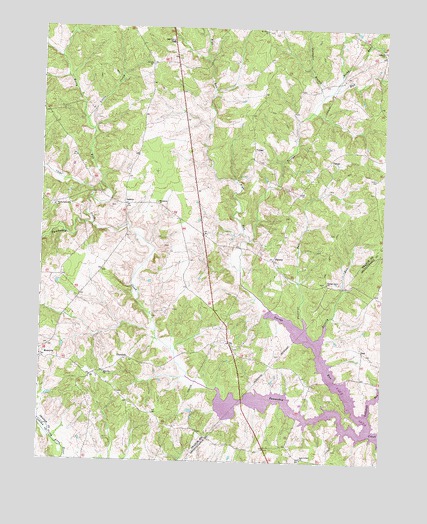
Lahore, VA USGS Topographic Map
Click on map above to begin viewing in our Map Viewer.

This topographic map contains these locations and features:
Feature Name Type Latitude Longitude GNIS ID View Map
Antioch Baptist Church CemeteryCemeteryN38.2443°W77.8762°1494738View Map
Antioch ChurchChurchN38.2437°W77.8758°1462515View Map
Bakers PointCapeN38.1396°W77.8814°1740257View Map
Bennetts PointCapeN38.1426°W77.9083°1740258View Map
Berry RunStreamN38.2010°W77.9817°1463110View Map
Bethel CemeteryCemeteryN38.2393°W77.9603°1494739View Map
Bethel ChurchChurchN38.2393°W77.9606°1463199View Map
Beverly RunStreamN38.1651°W77.8950°1463286View Map
Buzzard Woods PointCapeN38.1382°W77.8953°1740267View Map
Clear CreekStreamN38.1929°W77.9814°1464968View Map
Conway PointCapeN38.1354°W77.8814°1740271View Map
DanPopulated PlaceN38.1571°W77.8817°1495453View Map
Daniels PointCapeN38.1640°W77.9036°1748977View Map
DantonPopulated PlaceN38.1832°W77.9153°1477246View Map
Days BridgeBridgeN38.1485°W77.8928°1740177View Map
Dickersons PointCapeN38.1443°W77.9206°1740178View Map
Earls PointCapeN38.1526°W77.8936°1740276View Map
Ellisville ChurchChurchN38.1501°W77.9764°1466254View Map
Foremost RunStreamN38.1385°W77.8800°1466755View Map
Frazers BridgeBridgeN38.1690°W77.9158°1748978View Map
Frazers PointCapeN38.1624°W77.9081°1748979View Map
Freemans PointCapeN38.1340°W77.8886°1740280View Map
Graftons BridgeBridgeN38.1390°W77.9050°1740283View Map
Groomes PointCapeN38.1426°W77.9317°1748980View Map
Henrys PointCapeN38.1379°W77.9014°1740290View Map
Hickory CutBayN38.1315°W77.8833°1740291View Map
Horsepen BranchStreamN38.2307°W77.8978°1468286View Map
Isabella Lightfoot Training School (historical)SchoolN38.2385°W77.9603°1494747View Map
Kirk O'CliffPopulated PlaceN38.1262°W77.9039°1740199View Map
Kirk O'Cliff ChurchChurchN38.1257°W77.9036°1469038View Map
LahorePopulated PlaceN38.1987°W77.9694°1477469View Map
Lake Anna LandingLocaleN38.1424°W77.9250°1740300View Map
Lightfoot Elementary SchoolSchoolN38.2461°W77.9534°1469426View Map
Little CreekStreamN38.2235°W77.9839°1469516View Map
Macedonia ChurchChurchN38.1993°W77.9578°1469979View Map
MonroviaPopulated PlaceN38.1551°W77.9989°1477549View Map
Moores PointCapeN38.1571°W77.8969°1740306View Map
Mount Olive CemeteryCemeteryN38.2492°W77.9186°1494755View Map
Mount Olive ChurchChurchN38.2493°W77.9186°1470982View Map
North Pamunkey CemeteryCemeteryN38.1982°W77.9964°1494759View Map
North Pamunkey ChurchChurchN38.1985°W77.9950°1471630View Map
Orange Grove CemeteryCemeteryN38.1768°W77.8961°1494765View Map
Orange Grove ChurchChurchN38.1765°W77.8956°1471938View Map
Pamunkey BridgeBridgeN38.1426°W77.9256°1740216View Map
Pleasant RunStreamN38.1662°W77.9039°1472505View Map
Riga RunStreamN38.1887°W77.9239°1473217View Map
Rocky RunStreamN38.2321°W77.8942°1473492View Map
Sam Goodwins CoveBayN38.1357°W77.9025°1740316View Map
Simms PointCapeN38.1390°W77.8908°1740321View Map
Sullivans LandingLocaleN38.1485°W77.8872°1740324View Map
Sunnyside School (historical)SchoolN38.2321°W77.9061°1494777View Map
TatumPopulated PlaceN38.2112°W77.8953°1496295View Map
Terrells Store (historical)LocaleN38.1837°W77.9189°1494778View Map
Terrys RunStreamN38.1346°W77.8794°1475549View Map
ThornhillPopulated PlaceN38.1543°W77.9681°1496314View Map
Thornhill School (historical)SchoolN38.1507°W77.9794°1494779View Map
Towsey PointCapeN38.1424°W77.9147°1740328View Map
VulcanPopulated PlaceN38.2149°W77.9225°1496364View Map
Woodside BranchStreamN38.1396°W77.8939°1740335View Map
Woodville PointCapeN38.1607°W77.8997°1740336View Map
Woolfolk PointCapeN38.1429°W77.8781°1740337View Map

Note: Coordinates in the location and feature list above are referenced to NAD83 datum.


Copyright (C) 2008-2024 Ryan Niemi / Sunset Dynamics ... All Rights Reserved