TopoQuest Logo
Do you find TopoQuest useful?
Help keep TopoQuest running and adding new maps/features by donating!
Bitcoin:  19c7KJd3qBynnjoSw5npx9KScwjBe4ifkT
Litecoin:  LXs6TkuXGGXo1vDsWCkWVdjQX94eUKd6ui
Home View Maps Find Maps Find Places Resources & Links


Mineral, Virginia Topographic Map

USGS Map Title: Mineral, VA
USGS Map MRC: 38077A8
DRG (GeoTIFF) Download: o38077a8.tif


Neighboring USGS Topographic Map Quads:


  Orange, VA  
38078B1
 

  Lahore, VA  
38077B8
 

  Belmont, VA  
38077B7
 

  Louisa, VA  
38078A1
 

  Mineral, VA  
38077A8
 

  Lake Anna West, VA  
38077A7
 

  Ferncliff, VA  
37078H1
 

  Pendleton, VA  
37077H8
 

  Buckner, VA  
37077H7


Map MRC Location:

N39°
W78°
N39°
W77°
H8 H7 H6 H5 H4 H3 H2 H1
G8 G7 G6 G5 G4 G3 G2 G1
F8 F7 F6 F5 F4 F3 F2 F1
E8 E7 E6 E5 E4 E3 E2 E1
D8 D7 D6 D5 D4 D3 D2 D1
C8 C7 C6 C5 C4 C3 C2 C1
B8 B7 B6 B5 B4 B3 B2 B1
A8 A7 A6 A5 A4 A3 A2 A1
N38°
W78°
N38°
W77°

Mineral, VA USGS 1:24K Topographic Map Preview:
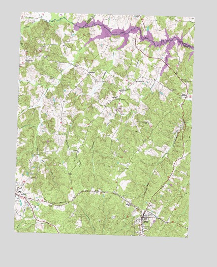
Mineral, VA USGS Topographic Map
Click on map above to begin viewing in our Map Viewer.

This topographic map contains these locations and features:
Feature Name Type Latitude Longitude GNIS ID View Map
Barns PointCapeN38.1093°W77.8850°1748930View Map
Bazzanella PointCapeN38.1104°W77.8928°1748931View Map
Bibbs StoreLocaleN38.0918°W77.9494°1463289View Map
Calvary Chapel of LouisaChurchN38.0103°W77.9069°2437689View Map
Carpenters Ford (historical)CrossingN38.1176°W77.9503°1740268View Map
Caves PointCapeN38.1126°W77.9258°1748941View Map
Chaney CreekStreamN38.0601°W77.9850°1464735View Map
Christopher CreekStreamN38.0910°W77.8983°1464898View Map
Church of the IncarnationChurchN38.0618°W77.9072°1494679View Map
Church of the Lord JesusChurchN38.0646°W77.9058°1464904View Map
Cuzco (historical)Populated PlaceN38.0382°W77.8869°1494681View Map
Dickinson StoreLocaleN38.0824°W77.9233°1465781View Map
Duckinghoe CreekStreamN38.1054°W77.9303°1466021View Map
Elizabeth Trice Walton ParkParkN38.0051°W77.9061°1494685View Map
Ellis Mill (historical)LocaleN38.1218°W77.9869°1494684View Map
EllisvillePopulated PlaceN38.0974°W77.9944°1477303View Map
Ellisville Post OfficePost OfficeN38.0974°W77.9944°1759811View Map
Enon ChurchChurchN38.0835°W77.9206°1466316View Map
First Bible Way ChurchChurchN38.0999°W77.9811°1463294View Map
Gold Mine ChurchChurchN38.0954°W77.9597°1467190View Map
Gold Mine Church (historical)ChurchN38.1015°W77.9861°1494687View Map
Gold Mine CreekStreamN38.1062°W77.9528°1467191View Map
Grace Adams Davis Memorial PlaygroundParkN38.0126°W77.9069°1494688View Map
Harris BranchStreamN38.1115°W77.8925°1740286View Map
Harris PointCapeN38.1132°W77.9114°1740287View Map
Harris PondReservoirN38.1175°W77.9084°1740288View Map
Hellems PointCapeN38.1160°W77.9350°1740289View Map
Hickory CreekStreamN38.1215°W77.9842°1467980View Map
Holladay BridgeBridgeN38.1107°W77.8856°1494693View Map
Holladay Mill (historical)LocaleN38.1110°W77.8853°1740193View Map
Holladay Mill CreekStreamN38.1107°W77.8847°1740292View Map
Holladay Mill Dam (historical)DamN38.1118°W77.8858°1740293View Map
Holy Church of the Living GodChurchN38.0896°W77.8833°1468183View Map
Jerusalem ChurchChurchN38.0835°W77.8894°1468712View Map
John Goodwins Ford (historical)CrossingN38.1149°W77.9247°1740298View Map
Keens Mill (historical)LocaleN38.1207°W77.9719°1494703View Map
Louisa Baptist ChurchChurchN38.0214°W77.9989°2504843View Map
Louisa County Airport/Freeman FieldAirportN38.0112°W77.9684°1480232View Map
Louisa County High SchoolSchoolN38.0175°W77.9211°1494709View Map
Louisa County Middle SchoolSchoolN38.0203°W77.9253°1494711View Map
Louisa County Rescue SquadBuildingN38.0143°W77.9679°2075279View Map
Louisa Police DepartmentBuildingN38.0220°W77.9991°2332150View Map
Louisa Volunteer Fire Department Company 1BuildingN38.0211°W77.9985°2075314View Map
Mansfield (historical)Populated PlaceN38.0901°W77.9125°1494713View Map
Mansfield Post Office (historical)Post OfficeN38.0901°W77.9125°1759821View Map
Martins PointCapeN38.1096°W77.9061°1748957View Map
MineralPopulated PlaceN38.0107°W77.9086°1495954View Map
Mineral DistrictCivilN38.0166°W77.9337°1927408View Map
Mineral Post OfficePost OfficeN38.0068°W77.9086°2766251View Map
Mineral United Methodist ChurchChurchN38.0079°W77.9114°1494717View Map
Mineral Volunteer Fire Department Company 2BuildingN38.0106°W77.9074°2075273View Map
Mineral Volunteer Rescue SquadBuildingN38.0105°W77.9073°2075280View Map
Miners Chapel (historical)ChurchN38.0437°W77.8850°1494718View Map
Mount Gillian ChurchChurchN38.0779°W77.9286°1470876View Map
Mount Gillian New Site ChurchChurchN38.0879°W77.9158°1470877View Map
Mount Pleasant ChurchChurchN38.0774°W77.9275°1471043View Map
North Anna BridgeBridgeN38.1160°W77.9136°1740308View Map
Nunn CreekStreamN38.0729°W77.9833°1471687View Map
Purcells PointCapeN38.1171°W77.9567°1748963View Map
Red House PointCapeN38.1182°W77.9428°1748964View Map
RibbonPopulated PlaceN38.0468°W77.9561°1477679View Map
Saint Johns ChurchChurchN38.0882°W77.8789°1473782View Map
Sunning IslandIslandN38.1157°W77.9183°1748971View Map
Tanyard BranchStreamN38.0088°W77.9939°1475468View Map
Thessalonian ChurchChurchN38.0215°W77.9225°1475623View Map
Tomahawk CreekStreamN38.1074°W77.9075°1475765View Map
Town of LouisaCivilN38.0212°W77.9985°2391275View Map
Town of MineralCivilN38.0068°W77.9061°2391308View Map
Trinity ChurchChurchN38.0799°W77.8822°1475880View Map
Waddys PointCapeN38.1204°W77.9461°1740330View Map
Wares CrossroadsPopulated PlaceN38.0796°W77.8800°1477857View Map
Wares Crossroads Post OfficePost OfficeN38.0796°W77.8800°1759832View Map
Wares Crossroads Post OfficePost OfficeN38.0796°W77.8800°1764984View Map
Wesleyan ChurchChurchN38.0596°W77.9067°1494734View Map
White CreekStreamN38.0824°W77.9783°1476581View Map

Note: Coordinates in the location and feature list above are referenced to NAD83 datum.


Copyright (C) 2008-2024 Ryan Niemi / Sunset Dynamics ... All Rights Reserved