TopoQuest Logo
Do you find TopoQuest useful?
Help keep TopoQuest running and adding new maps/features by donating!
Bitcoin:  19c7KJd3qBynnjoSw5npx9KScwjBe4ifkT
Litecoin:  LXs6TkuXGGXo1vDsWCkWVdjQX94eUKd6ui
Home View Maps Find Maps Find Places Resources & Links


Koran, Louisiana Topographic Map

USGS Map Title: Koran, LA
USGS Map MRC: 32093D4
DRG (GeoTIFF) Download: o32093d4.tif


Neighboring USGS Topographic Map Quads:


  Eastwood, LA  
32093E5
 

  Doyline, LA  
32093E4
 

  Minden South, LA  
32093E3
 

  Sligo, LA  
32093D5
 

  Koran, LA  
32093D4
 

  Heflin, LA  
32093D3
 

  Elm Grove, LA  
32093C5
 

  Bossier Point, LA  
32093C4
 

  Ringgold, LA  
32093C3


Map MRC Location:

N33°
W94°
N33°
W93°
H8 H7 H6 H5 H4 H3 H2 H1
G8 G7 G6 G5 G4 G3 G2 G1
F8 F7 F6 F5 F4 F3 F2 F1
E8 E7 E6 E5 E4 E3 E2 E1
D8 D7 D6 D5 D4 D3 D2 D1
C8 C7 C6 C5 C4 C3 C2 C1
B8 B7 B6 B5 B4 B3 B2 B1
A8 A7 A6 A5 A4 A3 A2 A1
N32°
W94°
N32°
W93°

Koran, LA USGS 1:24K Topographic Map Preview:
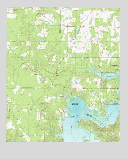
Koran, LA USGS Topographic Map
Click on map above to begin viewing in our Map Viewer.

This topographic map contains these locations and features:
Feature Name Type Latitude Longitude GNIS ID View Map
Adam PointCapeN32.3935°W93.4193°553260View Map
Bethlehem ChurchChurchN32.4971°W93.4930°532994View Map
Bracks ChapelChurchN32.4038°W93.4882°533357View Map
Camp Zion CemeteryCemeteryN32.4935°W93.4621°540934View Map
Camp Zion ChurchChurchN32.4965°W93.4652°533664View Map
Chaney BranchStreamN32.4474°W93.4646°533871View Map
Clarke BayouStreamN32.4424°W93.4038°554001View Map
Fairview LandingLocaleN32.4029°W93.4346°550820View Map
Fairview PointCapeN32.3985°W93.4291°534888View Map
Foxskin BayouStreamN32.4521°W93.4674°554471View Map
Gilmer CemeteryCemeteryN32.4290°W93.4402°535228View Map
Jerusalem CemeteryCemeteryN32.4426°W93.4799°554873View Map
Jerusalem ChurchChurchN32.4377°W93.4660°536034View Map
KoranPopulated PlaceN32.4252°W93.4630°543366View Map
Koran CemeteryCemeteryN32.4424°W93.4679°554945View Map
Lake BistineauReservoirN32.4066°W93.3905°553670View Map
Lake Bistineau State ParkParkN32.4440°W93.3804°536270View Map
Marshall CemeteryCemeteryN32.3971°W93.4552°536909View Map
McDowell Pond DamDamN32.4985°W93.4368°556988View Map
Parish Governing Authority District 1CivilN32.3956°W93.4949°1929725View Map
Parish Governing Authority District 12CivilN32.4823°W93.3822°1929835View Map
Peggys IslandIslandN32.3765°W93.4130°538047View Map
Pine BluffCliffN32.3968°W93.3782°549096View Map
Plum Orchard IslandIslandN32.4113°W93.3841°538274View Map
Plum Orchard LandingPopulated PlaceN32.4143°W93.3763°543585View Map
Prairie BayouStreamN32.4446°W93.4116°538384View Map
Saint Marks ChurchChurchN32.4785°W93.3946°538971View Map
Saint Marys ChurchChurchN32.4527°W93.4380°538988View Map
Saint Pauls CemeteryCemeteryN32.4368°W93.4463°539036View Map
Shirley Willis Pond DamDamN32.4568°W93.3868°556986View Map
South Bossier Volunteer Fire Department Station 3BuildingN32.3990°W93.4359°2673053View Map
Spring BranchStreamN32.3921°W93.4513°539569View Map
Suggs CemeteryCemeteryN32.3976°W93.4996°539716View Map
Tadpole LakeLakeN32.4066°W93.3906°556196View Map
Webster Parish Fire District 3 Doyline Fire DepartmentBuildingN32.4796°W93.3989°2672860View Map

Note: Coordinates in the location and feature list above are referenced to NAD83 datum.


Copyright (C) 2008-2024 Ryan Niemi / Sunset Dynamics ... All Rights Reserved