TopoQuest Logo
Do you find TopoQuest useful?
Help keep TopoQuest running and adding new maps/features by donating!
Bitcoin:  19c7KJd3qBynnjoSw5npx9KScwjBe4ifkT
Litecoin:  LXs6TkuXGGXo1vDsWCkWVdjQX94eUKd6ui
Home View Maps Find Maps Find Places Resources & Links


Sligo, Louisiana Topographic Map

USGS Map Title: Sligo, LA
USGS Map MRC: 32093D5
DRG (GeoTIFF) Download: o32093d5.tif


Neighboring USGS Topographic Map Quads:


  Bossier City, LA  
32093E6
 

  Eastwood, LA  
32093E5
 

  Doyline, LA  
32093E4
 

  Shreveport East, LA  
32093D6
 

  Sligo, LA  
32093D5
 

  Koran, LA  
32093D4
 

  Wallace Lake, LA  
32093C6
 

  Elm Grove, LA  
32093C5
 

  Bossier Point, LA  
32093C4


Map MRC Location:

N33°
W94°
N33°
W93°
H8 H7 H6 H5 H4 H3 H2 H1
G8 G7 G6 G5 G4 G3 G2 G1
F8 F7 F6 F5 F4 F3 F2 F1
E8 E7 E6 E5 E4 E3 E2 E1
D8 D7 D6 D5 D4 D3 D2 D1
C8 C7 C6 C5 C4 C3 C2 C1
B8 B7 B6 B5 B4 B3 B2 B1
A8 A7 A6 A5 A4 A3 A2 A1
N32°
W94°
N32°
W93°

Sligo, LA USGS 1:24K Topographic Map Preview:
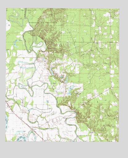
Sligo, LA USGS Topographic Map
Click on map above to begin viewing in our Map Viewer.

This topographic map contains these locations and features:
Feature Name Type Latitude Longitude GNIS ID View Map
Barksdale Air Force BaseMilitaryN32.4959°W93.6118°2512042View Map
Birdsnest BranchStreamN32.4488°W93.5168°533142View Map
Buffalo LakeSwampN32.4010°W93.5705°533517View Map
Burns CemeteryCemeteryN32.4915°W93.5049°533566View Map
Buzzard Roost BendBendN32.4254°W93.6016°533599View Map
Cane BendBendN32.4657°W93.5891°533709View Map
CaplisPopulated PlaceN32.3971°W93.6096°541062View Map
Church of God in ChristChurchN32.4679°W93.5232°533953View Map
Coleman BranchStreamN32.3935°W93.5246°534035View Map
Cypress LakeLakeN32.4360°W93.5766°554175View Map
Ebenezer ChurchChurchN32.4204°W93.5457°534758View Map
Fifi BayouStreamN32.4915°W93.6041°534947View Map
Honey LakeLakeN32.4116°W93.5785°554744View Map
Horseshoe CreekStreamN32.4546°W93.5199°535814View Map
Jesus Christ ChurchChurchN32.4402°W93.5105°541029View Map
Jordan Temple ChurchChurchN32.4513°W93.5702°536120View Map
Lawson BranchStreamN32.3832°W93.5252°536362View Map
Lays BayouStreamN32.4143°W93.6202°536364View Map
Long PointCapeN32.3757°W93.6066°536709View Map
Marden Lake BayouGutN32.4699°W93.5835°536894View Map
Marshall Hill School (historical)SchoolN32.4168°W93.5455°541028View Map
Mary Queen of Peace ChurchChurchN32.4010°W93.6166°536930View Map
MayersPopulated PlaceN32.4082°W93.6216°555255View Map
Mayflower CemeteryCemeteryN32.4582°W93.5738°536947View Map
Mayflower ChurchChurchN32.4593°W93.5824°536948View Map
Montgomery LakeLakeN32.3836°W93.5323°555354View Map
Moon LakeLakeN32.4645°W93.6145°555361View Map
Mount Canaan ChurchChurchN32.4613°W93.5313°537300View Map
OaklandPopulated PlaceN32.4682°W93.5096°541155View Map
Oakland CemeteryCemeteryN32.4624°W93.5218°537801View Map
PalmettoPopulated PlaceN32.3971°W93.5577°543565View Map
Round LakeLakeN32.4296°W93.5727°555854View Map
Saint Paul ChurchChurchN32.4721°W93.5091°539025View Map
SligoPopulated PlaceN32.4510°W93.5816°543674View Map
South Bossier Parish Fire District 2BuildingN32.4240°W93.5132°2672895View Map
South Bossier Volunteer Fire Department Station 4BuildingN32.4496°W93.5772°2673051View Map
South Bossier Volunteer Fire Department Station 5BuildingN32.3845°W93.5942°2673042View Map
TaylortownPopulated PlaceN32.3865°W93.5960°539809View Map
Walson LakeLakeN32.3837°W93.6110°556357View Map
Waterloo Number 1 ChurchChurchN32.3763°W93.5807°540251View Map

Note: Coordinates in the location and feature list above are referenced to NAD83 datum.


Copyright (C) 2008-2024 Ryan Niemi / Sunset Dynamics ... All Rights Reserved