TopoQuest Logo
Do you find TopoQuest useful?
Help keep TopoQuest running and adding new maps/features by donating!
Home View Maps Find Maps Find Places Resources & Links


Crawfordville East, Florida Topographic Map

USGS Map Title: Crawfordville East, FL
USGS Map MRC: 30084B3
DRG (GeoTIFF) Download: o30084b3.tif


Neighboring USGS Topographic Map Quads:


  Hilliardville, FL  
30084C4
 

  Lake Munson, FL  
30084C3
 

  Woodville, FL  
30084C2
 

  Crawfordville West, FL  
30084B4
 

  Crawfordville East, FL  
30084B3


  Sopchoppy, FL  
30084A4
 

  Spring Creek, FL  
30084A3


Map MRC Location:

N31°
W85°
N31°
W84°
H8 H7 H6 H5 H4 H3 H2 H1
G8 G7 G6 G5 G4 G3 G2 G1
F8 F7 F6 F5 F4 F3 F2 F1
E8 E7 E6 E5 E4 E3 E2 E1
D8 D7 D6 D5 D4 D3 D2 D1
C8 C7 C6 C5 C4 C3 C2 C1
B8 B7 B6 B5 B4 B3 B2 B1
A8 A7 A6 A5 A4 A3 A2 A1
N30°
W85°
N30°
W84°

Crawfordville East, FL USGS 1:24K Topographic Map Preview:
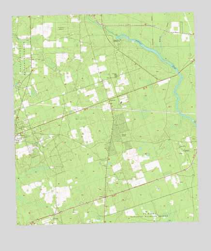
Crawfordville East, FL USGS Topographic Map
Click on map above to begin viewing in our Map Viewer.

This topographic map contains these locations and features:
Feature Name Type Latitude Longitude GNIS ID View Map
Beaulah ChurchChurchN30.17631°W84.37184°305260View Map
Causseaux CemeteryCemeteryN30.21270°W84.30489°306885View Map
Cherokee SinkBasinN30.21326°W84.30323°305474View Map
Crawfordville Census Designated PlaceCensusN30.19955°W84.36340°2583338View Map
Crawfordville Post OfficePost OfficeN30.19413°W84.37387°2783459View Map
Duggar CemeteryCemeteryN30.22409°W84.35795°306886View Map
East Wakulla DivisionCivilN30.16235°W84.25166°1935755View Map
Edward Ball Wakulla Springs State ParkParkN30.23298°W84.29212°1946070View Map
First Baptist ChurchChurchN30.20437°W84.30823°306804View Map
Hyde ParkPopulated PlaceN30.16993°W84.26184°305850View Map
IvanPopulated PlaceN30.22354°W84.36212°305861View Map
Ivan ChurchChurchN30.12937°W84.28323°305862View Map
Jump CreekStreamN30.23520°W84.36962°305883View Map
McBride SloughStreamN30.22548°W84.27379°306015View Map
Medart Assembly of God ChurchChurchN30.18354°W84.36934°306776View Map
Mount Olive Primitive Baptist ChurchChurchN30.18215°W84.37073°306775View Map
Pilgrims Rest ChurchChurchN30.12798°W84.35018°306219View Map
Raher CemeteryCemeteryN30.20964°W84.26739°306889View Map
Richardson CemeteryCemeteryN30.14166°W84.31277°306894View Map
Riversink Baptist ChurchChurchN30.18354°W84.36934°306740View Map
Saint Pauls ChurchChurchN30.15909°W84.31184°306330View Map
Saint Pauls United Methodist ChurchChurchN30.15993°W84.31240°306803View Map
Salem ChurchChurchN30.21215°W84.30684°306336View Map
Seventh Day Adventist ChurchChurchN30.18076°W84.37490°306732View Map
ShadevillePopulated PlaceN30.19937°W84.30879°306371View Map
Shadeville Elementary SchoolSchoolN30.21584°W84.31801°306668View Map
The Church of Jesus Christ of Latter Day Saints-CrawfordvilleChurchN30.18215°W84.36796°306769View Map
Thessalonia Missionary ChurchChurchN30.16770°W84.25823°306490View Map
Wakulla Club Airport (historical)AirportN30.21100°W84.25448°309871View Map
Wakulla County Ambulance ServiceBuildingN30.18570°W84.36498°2661709View Map
Wakulla GardensPopulated PlaceN30.17659°W84.30768°306549View Map
Wakulla Middle SchoolSchoolN30.12723°W84.37264°306669View Map
Wakulla SpringsSpringN30.23539°W84.30281°2771542View Map
Wakulla SpringsPopulated PlaceN30.23354°W84.30518°306552View Map
Walker CemeteryCemeteryN30.15520°W84.30100°306884View Map
Wasupa (historical)Populated PlaceN30.21687°W84.29990°306986View Map

Note: Coordinates in the location and feature list above are referenced to NAD83 datum.


Copyright (C) 2008-2026 Ryan Niemi / Sunset Dynamics ... All Rights Reserved