TopoQuest Logo
Do you find TopoQuest useful?
Help keep TopoQuest running and adding new maps/features by donating!
Bitcoin:  19c7KJd3qBynnjoSw5npx9KScwjBe4ifkT
Litecoin:  LXs6TkuXGGXo1vDsWCkWVdjQX94eUKd6ui
Home View Maps Find Maps Find Places Resources & Links


Connersville, Indiana Topographic Map

USGS Map Title: Connersville, IN
USGS Map MRC: 39085F2
DRG (GeoTIFF) Download: o39085f2.tif


Neighboring USGS Topographic Map Quads:


  Lewisville, IN  
39085G3
 

  Cambridge City, IN  
39085G2
 

  Jacksonburg, IN  
39085G1
 

  Falmouth, IN  
39085F3
 

  Connersville, IN  
39085F2
 

  Brownsville, IN  
39085F1
 

  New Salem, IN  
39085E3
 

  Alpine, IN  
39085E2
 

  Everton, IN  
39085E1


Map MRC Location:

N40°
W86°
N40°
W85°
H8 H7 H6 H5 H4 H3 H2 H1
G8 G7 G6 G5 G4 G3 G2 G1
F8 F7 F6 F5 F4 F3 F2 F1
E8 E7 E6 E5 E4 E3 E2 E1
D8 D7 D6 D5 D4 D3 D2 D1
C8 C7 C6 C5 C4 C3 C2 C1
B8 B7 B6 B5 B4 B3 B2 B1
A8 A7 A6 A5 A4 A3 A2 A1
N39°
W86°
N39°
W85°

Connersville, IN USGS 1:24K Topographic Map Preview:
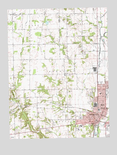
Connersville, IN USGS Topographic Map
Click on map above to begin viewing in our Map Viewer.

This topographic map contains these locations and features:
Feature Name Type Latitude Longitude GNIS ID View Map
BeesonsPopulated PlaceN39.7217°W85.1330°430744View Map
BentonvillePopulated PlaceN39.7453°W85.1941°430830View Map
Bentonville ChurchChurchN39.7376°W85.2435°430831View Map
Bentonville Church CemeteryCemeteryN39.7385°W85.2439°2709100View Map
Bentonville Volunteer Fire DepartmentBuildingN39.7456°W85.2424°2626211View Map
Bunker HillPopulated PlaceN39.6334°W85.2125°431809View Map
Caldwell CemeteryCemeteryN39.7023°W85.1974°2710394View Map
Campbell CemeteryCemeteryN39.6762°W85.2433°432079View Map
City of ConnersvilleCivilN39.6583°W85.1410°2393620View Map
ConnersvillePopulated PlaceN39.6412°W85.1411°432888View Map
Connersville Area Vocational SchoolSchoolN39.6367°W85.1597°446589View Map
Connersville City CemeteryCemeteryN39.6502°W85.1364°2708603View Map
Connersville Fire Department Station 1 HeadquartersBuildingN39.6432°W85.1401°2625555View Map
Connersville Fire Department Station 3BuildingN39.6762°W85.1382°2626243View Map
Connersville Junior High NorthSchoolN39.6556°W85.1333°446587View Map
Connersville Police StationBuildingN39.6414°W85.1389°2758053View Map
Connersville Senior High SchoolSchoolN39.6367°W85.1597°446588View Map
Dale CemeteryCemeteryN39.6444°W85.1603°433290View Map
Dungan AirportAirportN39.7056°W85.2221°2770218View Map
East View SchoolSchoolN39.6362°W85.1297°433940View Map
Eastview Elementary SchoolSchoolN39.6362°W85.1597°446586View Map
Fayette CountyCivilN39.6401°W85.1787°450349View Map
Fayette County Emergency Medical ServicesBuildingN39.6491°W85.1393°2719326View Map
Fayette County Sheriff's OfficeBuildingN39.6404°W85.1411°2758451View Map
Fayette Regional Health SystemHospitalN39.6562°W85.1327°2660491View Map
Grandview Elementary SchoolSchoolN39.6673°W85.2239°435308View Map
HarrisburgPopulated PlaceN39.6867°W85.1800°449668View Map
Heartsavers Emergency Medical ServicesBuildingN39.6429°W85.1386°2719403View Map
HuberPopulated PlaceN39.6862°W85.1391°436563View Map
Junior High School NorthSchoolN39.6562°W85.2111°437146View Map
Junior High School SouthSchoolN39.6528°W85.2105°437147View Map
Kirkwood CemeteryCemeteryN39.7491°W85.2433°2710382View Map
Lick Creek CemeteryCemeteryN39.6700°W85.1759°438033View Map
Longwood CrossingPopulated PlaceN39.6559°W85.2272°438294View Map
Manlove LakeReservoirN39.7363°W85.2005°448646View Map
Manlove Park DamDamN39.7350°W85.2016°448645View Map
Maplewood Elementary SchoolSchoolN39.6531°W85.1502°438588View Map
Martin CemeteryCemeteryN39.6492°W85.2144°438662View Map
Methodist Farm CemeteryCemeteryN39.7067°W85.1366°2710389View Map
Mettel FieldAirportN39.6969°W85.1349°449129View Map
Mixed CreekStreamN39.7353°W85.1875°439300View Map
Parker CemeteryCemeteryN39.6316°W85.1470°2710170View Map
Roberts ParkParkN39.6695°W85.1452°442161View Map
Tate CemeteryCemeteryN39.6263°W85.2049°2710831View Map
Thomas CemeteryCemeteryN39.6903°W85.1815°2710395View Map
Township of ConnersvilleCivilN39.6279°W85.1679°453246View Map
Township of HarrisonCivilN39.6864°W85.1794°453386View Map
Tyner CrossingPopulated PlaceN39.6548°W85.1769°445029View Map
Valley Grove ChurchChurchN39.7314°W85.2425°445196View Map
WCNB-AM (Connersville)TowerN39.6384°W85.1483°448454View Map
WCNB-FMTowerN39.6384°W85.1483°448966View Map
Whitwater CanalCanalN39.7131°W85.2130°445998View Map
Wiley Chapel CemeteryCemeteryN39.6651°W85.2436°445901View Map

Note: Coordinates in the location and feature list above are referenced to NAD83 datum.


Copyright (C) 2008-2024 Ryan Niemi / Sunset Dynamics ... All Rights Reserved