TopoQuest Logo
Do you find TopoQuest useful?
Help keep TopoQuest running and adding new maps/features by donating!
Bitcoin:  19c7KJd3qBynnjoSw5npx9KScwjBe4ifkT
Litecoin:  LXs6TkuXGGXo1vDsWCkWVdjQX94eUKd6ui
Home View Maps Find Maps Find Places Resources & Links


Concan, Texas Topographic Map

USGS Map Title: Concan, TX
USGS Map MRC: 29099D6
DRG (GeoTIFF) Download: o29099d6.tif


Neighboring USGS Topographic Map Quads:


  Reagan Wells, TX  
29099E7
 

  Magers Crossing, TX  
29099E6
 

  Utopia, TX  
29099E5
 

  Deep Creek, TX  
29099D7
 

  Concan, TX  
29099D6
 

  Trio, TX  
29099D5
 

  Sevenmile Hill, TX  
29099C7
 

  Knippa, TX  
29099C6
 

  Blanco Lake, TX  
29099C5


Map MRC Location:

N30°
W100°
N30°
W99°
H8 H7 H6 H5 H4 H3 H2 H1
G8 G7 G6 G5 G4 G3 G2 G1
F8 F7 F6 F5 F4 F3 F2 F1
E8 E7 E6 E5 E4 E3 E2 E1
D8 D7 D6 D5 D4 D3 D2 D1
C8 C7 C6 C5 C4 C3 C2 C1
B8 B7 B6 B5 B4 B3 B2 B1
A8 A7 A6 A5 A4 A3 A2 A1
N29°
W100°
N29°
W99°

Concan, TX USGS 1:24K Topographic Map Preview:
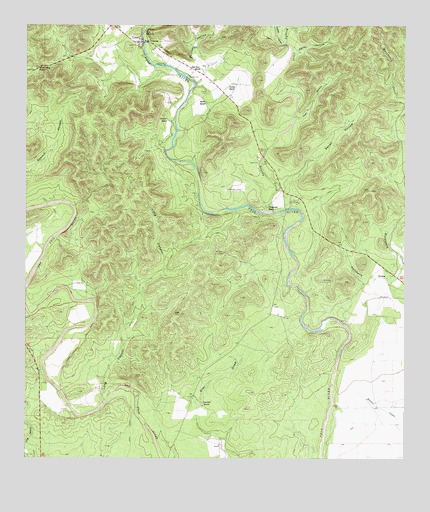
Concan, TX USGS Topographic Map
Click on map above to begin viewing in our Map Viewer.

This topographic map contains these locations and features:
Feature Name Type Latitude Longitude GNIS ID View Map
Annandale Ranch AirportAirportN29.4525°W99.6790°1387668View Map
Baylock HollowValleyN29.4863°W99.6921°1330160View Map
Big Tree RanchLocaleN29.4875°W99.6945°1330673View Map
Brushy CreekStreamN29.4461°W99.6684°1331425View Map
ConcanPopulated PlaceN29.4952°W99.7126°1333196View Map
Concan CemeteryCemeteryN29.4808°W99.6892°1333197View Map
Concan Post OfficePost OfficeN29.4977°W99.7175°2731886View Map
Deep CreekStreamN29.4163°W99.7487°1373364View Map
First CrossingPopulated PlaceN29.4952°W99.7109°1378293View Map
Fitzgerald RanchLocaleN29.4477°W99.6706°1335847View Map
Hackberry DrawValleyN29.4261°W99.6309°1337191View Map
Howard RanchLocaleN29.4727°W99.7031°1338192View Map
Jones HollowValleyN29.4912°W99.6627°1338858View Map
Long CanyonValleyN29.3919°W99.7230°1340444View Map
Meyer RanchLocaleN29.4780°W99.6901°1341456View Map
Pear HollowValleyN29.4734°W99.6613°1343727View Map
Pecan HollowValleyN29.4548°W99.6621°1343776View Map
Shut-in HollowValleyN29.4997°W99.7105°1347101View Map
Silver Mine PassGapN29.4880°W99.7462°1347137View Map
Stoner RanchLocaleN29.4822°W99.6828°1347966View Map
The Big TreeLocaleN29.4855°W99.6962°1348434View Map
The Shut-InSummitN29.4980°W99.7103°1348460View Map
Van Pelt HollowValleyN29.4950°W99.6649°1376572View Map
Van Pelt RanchLocaleN29.3913°W99.6914°1349186View Map

Note: Coordinates in the location and feature list above are referenced to NAD83 datum.


Copyright (C) 2008-2024 Ryan Niemi / Sunset Dynamics ... All Rights Reserved