TopoQuest Logo
Do you find TopoQuest useful?
Help keep TopoQuest running and adding new maps/features by donating!
Bitcoin:  19c7KJd3qBynnjoSw5npx9KScwjBe4ifkT
Litecoin:  LXs6TkuXGGXo1vDsWCkWVdjQX94eUKd6ui
Home View Maps Find Maps Find Places Resources & Links


Compton, Illinois Topographic Map

USGS Map Title: Compton, IL
USGS Map MRC: 41089F1
DRG (GeoTIFF) Download: o41089f1.tif


Neighboring USGS Topographic Map Quads:


  Ashton, IL  
41089G2
 

  Steward, IL  
41089G1
 

  Lee, IL  
41088G8
 

  Sublette, IL  
41089F2
 

  Compton, IL  
41089F1
 

  Paw Paw, IL  
41088F8
 

  Mendota West, IL  
41089E2
 

  Mendota East, IL  
41089E1
 

  Earlville, IL  
41088E8


Map MRC Location:

N42°
W90°
N42°
W89°
H8 H7 H6 H5 H4 H3 H2 H1
G8 G7 G6 G5 G4 G3 G2 G1
F8 F7 F6 F5 F4 F3 F2 F1
E8 E7 E6 E5 E4 E3 E2 E1
D8 D7 D6 D5 D4 D3 D2 D1
C8 C7 C6 C5 C4 C3 C2 C1
B8 B7 B6 B5 B4 B3 B2 B1
A8 A7 A6 A5 A4 A3 A2 A1
N41°
W90°
N41°
W89°

Compton, IL USGS 1:24K Topographic Map Preview:
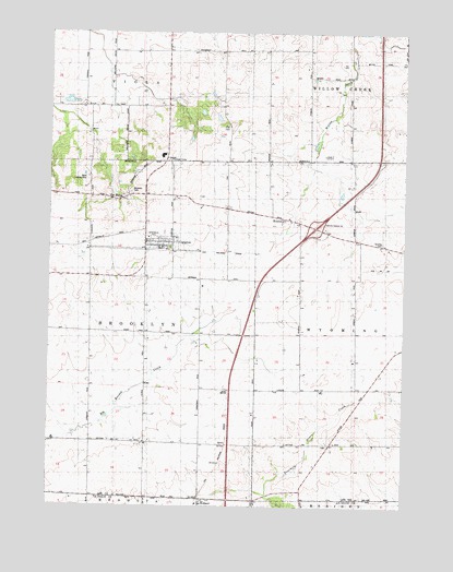
Compton, IL USGS Topographic Map
Click on map above to begin viewing in our Map Viewer.

This topographic map contains these locations and features:
Feature Name Type Latitude Longitude GNIS ID View Map
Brooklyn CemeteryCemeteryN41.7084°W89.0959°404912View Map
Brooklyn Lutheran CemeteryCemeteryN41.6409°W89.0904°1816520View Map
Carnahan Station (historical)LocaleN41.6934°W89.1115°1816521View Map
ComptonPopulated PlaceN41.6945°W89.0812°406429View Map
Compton Fire DepartmentBuildingN41.6934°W89.0866°2640703View Map
Compton Post OfficePost OfficeN41.6932°W89.0848°2788738View Map
Compton United Methodist ChurchChurchN41.6945°W89.0831°2042236View Map
Cottage Hill CemeteryCemeteryN41.6413°W89.0263°1816525View Map
Cottage Hill School (historical)SchoolN41.6403°W89.0254°424434View Map
Dunn AirportAirportN41.7197°W89.0283°2679073View Map
Earl Barnickel AirportAirportN41.6750°W89.1168°427184View Map
Fisk CemeteryCemeteryN41.7250°W89.0615°408406View Map
Gilmore FarmsLocaleN41.7053°W89.0797°2681080View Map
Harding CemeteryCemeteryN41.6942°W89.0079°409772View Map
Immanuel Lutheran ChurchChurchN41.6414°W89.0898°410794View Map
Interchange 82CrossingN41.6989°W89.0315°1718888View Map
Jonesville School (historical)LocaleN41.6959°W89.0154°424442View Map
Little Malugin GroveWoodsN41.7281°W89.0781°1816564View Map
Malugin GroveWoodsN41.7145°W89.1070°1816566View Map
Mathesius ParkParkN41.6956°W89.0881°424425View Map
Melugin Grove (historical)Populated PlaceN41.7070°W89.1126°425687View Map
RoxburyPopulated PlaceN41.7006°W89.0395°423137View Map
The BurgPopulated PlaceN41.7064°W89.0987°419627View Map
Township of BrooklynCivilN41.6717°W89.1096°428714View Map
Van Campen School (historical)SchoolN41.7295°W89.1101°424462View Map
Village of ComptonCivilN41.6940°W89.0861°2398609View Map
W Davis AirportAirportN41.7117°W89.1116°427183View Map
Walders Farm Airport (historical)AirportN41.6514°W89.0043°427654View Map
WellandPopulated PlaceN41.6267°W89.0709°420728View Map
Zimmerman FarmsLocaleN41.7036°W89.0717°2681078View Map

Note: Coordinates in the location and feature list above are referenced to NAD83 datum.


Copyright (C) 2008-2024 Ryan Niemi / Sunset Dynamics ... All Rights Reserved