TopoQuest Logo
Do you find TopoQuest useful?
Help keep TopoQuest running and adding new maps/features by donating!
Bitcoin:  19c7KJd3qBynnjoSw5npx9KScwjBe4ifkT
Litecoin:  LXs6TkuXGGXo1vDsWCkWVdjQX94eUKd6ui
Home View Maps Find Maps Find Places Resources & Links


Comins Lake, Nevada Topographic Map

USGS Map Title: Comins Lake, NV
USGS Map MRC: 39114B7
DRG (GeoTIFF) Download: o39114b7.tif


Neighboring USGS Topographic Map Quads:


  Ruth, NV  
39114C8
 

  East Ely, NV  
39114C7
 

  Cleve Creek Baldy, NV  
39114C6
 

  Ely, NV  
39114B8
 

  Comins Lake, NV  
39114B7
 

  Cave Creek, NV  
39114B6
 

  Ward Mountain, NV  
39114A8
 

  Ward Charcoal Ovens, NV  
39114A7
 

  Connors Pass, NV  
39114A6


Map MRC Location:

N40°
W115°
N40°
W114°
H8 H7 H6 H5 H4 H3 H2 H1
G8 G7 G6 G5 G4 G3 G2 G1
F8 F7 F6 F5 F4 F3 F2 F1
E8 E7 E6 E5 E4 E3 E2 E1
D8 D7 D6 D5 D4 D3 D2 D1
C8 C7 C6 C5 C4 C3 C2 C1
B8 B7 B6 B5 B4 B3 B2 B1
A8 A7 A6 A5 A4 A3 A2 A1
N39°
W115°
N39°
W114°

Comins Lake, NV USGS 1:24K Topographic Map Preview:
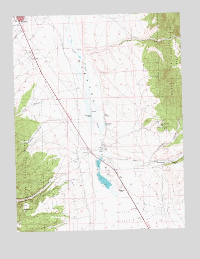
Comins Lake, NV USGS Topographic Map
Click on map above to begin viewing in our Map Viewer.

This topographic map contains these locations and features:
Feature Name Type Latitude Longitude GNIS ID View Map
Argus MillLocaleN39.1486°W114.7995°858746View Map
Blackrock SpringSpringN39.1381°W114.8712°858950View Map
Caesar ShaftMineN39.1849°W114.7647°859119View Map
CCC RanchLocaleN39.1719°W114.8111°859113View Map
Comins LakeReservoirN39.1516°W114.8077°859315View Map
Comins Lake DamDamN39.1649°W114.8125°863537View Map
Comins MeadowFlatN39.1277°W114.7967°859316View Map
Ely Post OfficePost OfficeN39.2440°W114.8712°864347View Map
Ely Volunteer Fire DepartmentBuildingN39.2423°W114.8677°2581237View Map
Fera NinetynineSpringN39.1344°W114.8603°862846View Map
Fish Pond SpringsSpringN39.1863°W114.8095°859713View Map
Gallaghers CanyonValleyN39.1883°W114.8528°859787View Map
Great Basin College Ely Branch CampusSchoolN39.2319°W114.8717°2087568View Map
Joe ShaftMineN39.1869°W114.7692°860211View Map
John ShaftMineN39.1852°W114.7658°860214View Map
Josephine ShaftMineN39.1838°W114.7645°860230View Map
Lowry CanyonValleyN39.2008°W114.8511°860435View Map
McDonough Pits MineMineN39.2352°W114.7728°852845View Map
Monitor FieldFlatN39.1624°W114.7675°860624View Map
Monitor MillLocaleN39.1638°W114.7600°860625View Map
Mosier CanyonValleyN39.2261°W114.8211°860652View Map
Sawmill CanyonValleyN39.1616°W114.8381°862839View Map
Shallenberger SpringSpringN39.1915°W114.8187°861331View Map
Steptoe MineMineN39.1830°W114.7645°852843View Map
Tamberlaine CanyonValleyN39.1633°W114.7797°861668View Map
Tamerlane (historical)Populated PlaceN39.1869°W114.7656°852844View Map
Vietti ShaftMineN39.1836°W114.7633°861853View Map
Wagner HillSummitN39.1852°W114.7614°852882View Map
White Pine County High SchoolSchoolN39.2345°W114.8733°2080249View Map
White Pine County Sheriff's OfficeBuildingN39.2419°W114.8675°2740020View Map
Willow CreekStreamN39.1277°W114.8058°862033View Map

Note: Coordinates in the location and feature list above are referenced to NAD83 datum.


Copyright (C) 2008-2024 Ryan Niemi / Sunset Dynamics ... All Rights Reserved