TopoQuest Logo
Do you find TopoQuest useful?
Help keep TopoQuest running and adding new maps/features by donating!
Bitcoin:  19c7KJd3qBynnjoSw5npx9KScwjBe4ifkT
Litecoin:  LXs6TkuXGGXo1vDsWCkWVdjQX94eUKd6ui
Home View Maps Find Maps Find Places Resources & Links


Collins NW, Arkansas Topographic Map

USGS Map Title: Collins NW, AR
USGS Map MRC: 33091F6
DRG (GeoTIFF) Download: o33091f6.tif


Neighboring USGS Topographic Map Quads:


  Relfs Bluff, AR  
33091G7
 

  Tyro, AR  
33091G6
 

  Gourd, AR  
33091G5
 

  Monticello North, AR  
33091F7
 

  Collins NW, AR  
33091F6
 

  Selma, AR  
33091F5
 

  Monticello South, AR  
33091E7
 

  Cominto, AR  
33091E6
 

  Collins, AR  
33091E5


Map MRC Location:

N34°
W92°
N34°
W91°
H8 H7 H6 H5 H4 H3 H2 H1
G8 G7 G6 G5 G4 G3 G2 G1
F8 F7 F6 F5 F4 F3 F2 F1
E8 E7 E6 E5 E4 E3 E2 E1
D8 D7 D6 D5 D4 D3 D2 D1
C8 C7 C6 C5 C4 C3 C2 C1
B8 B7 B6 B5 B4 B3 B2 B1
A8 A7 A6 A5 A4 A3 A2 A1
N33°
W92°
N33°
W91°

Collins NW, AR USGS 1:24K Topographic Map Preview:
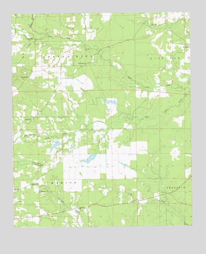
Collins NW, AR USGS Topographic Map
Click on map above to begin viewing in our Map Viewer.

This topographic map contains these locations and features:
Feature Name Type Latitude Longitude GNIS ID View Map
Bible ChurchChurchN33.6476°W91.7460°46497View Map
Brush PrairieAreaN33.6737°W91.6412°78977View Map
Byrd LakeReservoirN33.6979°W91.6804°80469View Map
Byrd Lake DamDamN33.6968°W91.6768°80468View Map
Collins BranchStreamN33.7365°W91.7251°47931View Map
Cooper PrairieAreaN33.7084°W91.7043°78990View Map
Godfrey CreekStreamN33.6798°W91.7068°49466View Map
Jose ChapelChurchN33.7132°W91.7387°50751View Map
Mount Tabor CemeteryCemeteryN33.7304°W91.6265°79049View Map
Mount Tabor School (historical)SchoolN33.7326°W91.6257°79050View Map
Mount Tabor United Methodist ChurchChurchN33.7301°W91.6257°77744View Map
Mount Zion African Methodist Episocpal ChurchChurchN33.6887°W91.7368°77752View Map
Mount Zion CemeteryCemeteryN33.6895°W91.7368°61689View Map
Old Piney (historical)Populated PlaceN33.6443°W91.6404°79057View Map
Old Union (historical)Populated PlaceN33.7209°W91.6957°79060View Map
Old Union Baptist ChurchChurchN33.7207°W91.6982°77913View Map
Old Union CemeteryCemeteryN33.7212°W91.6968°79061View Map
Old Union School (historical)SchoolN33.7207°W91.6979°79062View Map
Piney CemeteryCemeteryN33.6448°W91.6462°78017View Map
Rat CreekStreamN33.7346°W91.7337°53901View Map
Shady Grove CemeteryCemeteryN33.6462°W91.7318°54686View Map
Shady Grove Missionary Baptist ChurchChurchN33.6504°W91.7374°78322View Map
Tiffin PrairieAreaN33.6604°W91.6779°79099View Map
Township of Prairie (historical)CivilN33.6454°W91.6293°70295View Map
Township of Spring HillCivilN33.7404°W91.7408°66518View Map
Zion Hill Baptist ChurchChurchN33.6357°W91.7043°78836View Map

Note: Coordinates in the location and feature list above are referenced to NAD83 datum.


Copyright (C) 2008-2024 Ryan Niemi / Sunset Dynamics ... All Rights Reserved