TopoQuest Logo
Do you find TopoQuest useful?
Help keep TopoQuest running and adding new maps/features by donating!
Bitcoin:  19c7KJd3qBynnjoSw5npx9KScwjBe4ifkT
Litecoin:  LXs6TkuXGGXo1vDsWCkWVdjQX94eUKd6ui
Home View Maps Find Maps Find Places Resources & Links


Cohasset West, Minnesota Topographic Map

USGS Map Title: Cohasset West, MN
USGS Map MRC: 47093C6
DRG (GeoTIFF) Download: o47093c6.tif


Neighboring USGS Topographic Map Quads:


  Deer River NE, MN  
47093D7


  Deer River, MN  
47093C7
 

  Cohasset West, MN  
47093C6
 

  Cohasset East, MN  
47093C5


  Siseebakwet Lake, MN  
47093B6
 

  Grand Rapids, MN  
47093B5


Map MRC Location:

N48°
W94°
N48°
W93°
H8 H7 H6 H5 H4 H3 H2 H1
G8 G7 G6 G5 G4 G3 G2 G1
F8 F7 F6 F5 F4 F3 F2 F1
E8 E7 E6 E5 E4 E3 E2 E1
D8 D7 D6 D5 D4 D3 D2 D1
C8 C7 C6 C5 C4 C3 C2 C1
B8 B7 B6 B5 B4 B3 B2 B1
A8 A7 A6 A5 A4 A3 A2 A1
N47°
W94°
N47°
W93°

Cohasset West, MN USGS 1:24K Topographic Map Preview:
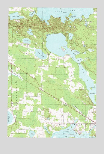
Cohasset West, MN USGS Topographic Map
Click on map above to begin viewing in our Map Viewer.

This topographic map contains these locations and features:
Feature Name Type Latitude Longitude GNIS ID View Map
Bass LakeLakeN47.3246°W93.6515°655256View Map
Battleship IslandIslandN47.3738°W93.6772°655271View Map
Blackwater CreekStreamN47.2683°W93.6510°655426View Map
Blackwater LakeLakeN47.2548°W93.6654°655428View Map
Bullhead LakeLakeN47.3317°W93.6413°655554View Map
Chase LakeLakeN47.3664°W93.7405°655699View Map
Clarke LakeLakeN47.3602°W93.6400°655738View Map
Crawford IslandIslandN47.3352°W93.6724°655864View Map
Echo BayBayN47.3486°W93.6944°656110View Map
Elm PointCapeN47.2997°W93.6274°656152View Map
Fishhouse BayBayN47.3322°W93.6560°656257View Map
Hog IslandIslandN47.3327°W93.6560°656603View Map
KXGP-FM (Deer River)TowerN47.2847°W93.6697°663030View Map
Lillian LakeLakeN47.3428°W93.7242°657001View Map
Little Deer LakeLakeN47.3689°W93.7165°657053View Map
Little Drum LakeLakeN47.2534°W93.7156°657058View Map
Loon LakeLakeN47.3479°W93.6618°657212View Map
Mallard LakeLakeN47.3346°W93.6341°657293View Map
Miller LakeLakeN47.3514°W93.7191°657398View Map
Perch LakeLakeN47.3385°W93.6423°657777View Map
Picnic IslandIslandN47.3677°W93.6633°657817View Map
Pohl CreekStreamN47.3247°W93.6458°657882View Map
Snyder BayBayN47.3241°W93.6499°658340View Map
Stevens BrookStreamN47.3324°W93.6894°658471View Map
Stevens LakeLakeN47.3301°W93.7043°658474View Map
Sunset PointCapeN47.2899°W93.6255°658548View Map
The NarrowsChannelN47.3216°W93.6497°658645View Map
Unorganized Territory of Deer LakeCivilN47.3315°W93.6739°663946View Map
Warburg LakeLakeN47.2579°W93.6949°658898View Map

Note: Coordinates in the location and feature list above are referenced to NAD83 datum.


Copyright (C) 2008-2024 Ryan Niemi / Sunset Dynamics ... All Rights Reserved