TopoQuest Logo
Do you find TopoQuest useful?
Help keep TopoQuest running and adding new maps/features by donating!
Bitcoin:  19c7KJd3qBynnjoSw5npx9KScwjBe4ifkT
Litecoin:  LXs6TkuXGGXo1vDsWCkWVdjQX94eUKd6ui
Home View Maps Find Maps Find Places Resources & Links


Cogan Station, Pennsylvania Topographic Map

USGS Map Title: Cogan Station, PA
USGS Map MRC: 41077C1
DRG (GeoTIFF) Download: o41077c1.tif


Neighboring USGS Topographic Map Quads:


  White Pine, PA  
41077D2
 

  Trout Run, PA  
41077D1
 

  Bodines, PA  
41076D8
 

  Salladasburg, PA  
41077C2
 

  Cogan Station, PA  
41077C1
 

  Montoursville North, PA  
41076C8
 

  Linden, PA  
41077B2
 

  Williamsport, PA  
41077B1
 

  Montoursville South, PA  
41076B8


Map MRC Location:

N42°
W78°
N42°
W77°
H8 H7 H6 H5 H4 H3 H2 H1
G8 G7 G6 G5 G4 G3 G2 G1
F8 F7 F6 F5 F4 F3 F2 F1
E8 E7 E6 E5 E4 E3 E2 E1
D8 D7 D6 D5 D4 D3 D2 D1
C8 C7 C6 C5 C4 C3 C2 C1
B8 B7 B6 B5 B4 B3 B2 B1
A8 A7 A6 A5 A4 A3 A2 A1
N41°
W78°
N41°
W77°

Cogan Station, PA USGS 1:24K Topographic Map Preview:
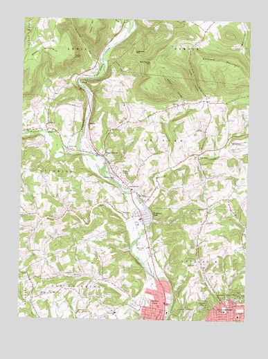
Cogan Station, PA USGS Topographic Map
Click on map above to begin viewing in our Map Viewer.

This topographic map contains these locations and features:
Feature Name Type Latitude Longitude GNIS ID View Map
Balls MillsPopulated PlaceN41.3181°W77.0269°1168673View Map
Beautys RunStreamN41.2801°W77.0630°1168986View Map
Bethel ChurchChurchN41.2667°W77.0775°1992595View Map
Blooming Grove MeetinghouseChurchN41.3240°W77.0041°1169848View Map
Bobst MountainSummitN41.3598°W77.1191°1192174View Map
Bodst Mountain SchoolSchoolN41.3642°W77.1150°1197445View Map
Bottle RunStreamN41.2604°W77.0402°1170029View Map
Bottle Run SchoolSchoolN41.2656°W77.0841°1197453View Map
Brandon ParkParkN41.2515°W77.0025°1992602View Map
Buchanan ChurchChurchN41.2598°W77.1122°1170496View Map
Cochran SchoolSchoolN41.2540°W77.0114°1172111View Map
Cogan StationLocaleN41.3179°W77.0791°1172137View Map
Cogan Station Post OfficePost OfficeN41.3117°W77.0734°2772640View Map
Cogan Station Post Office (historical)Post OfficeN41.3179°W77.0789°1197456View Map
Consistory FieldParkN41.2545°W77.0022°1172369View Map
Crescent School (historical)SchoolN41.3459°W77.0830°1197446View Map
Curtin SchoolSchoolN41.2517°W77.0036°1172853View Map
Daugherty RunStreamN41.3584°W77.0808°1172970View Map
Eagle ChurchChurchN41.2715°W77.0227°1173690View Map
Eagle SchoolSchoolN41.2762°W77.0252°1197455View Map
FairlawnPopulated PlaceN41.2929°W77.0619°1174444View Map
Falls Factory SchoolSchoolN41.3098°W77.0502°1197450View Map
Finkhaven AirportAirportN41.3686°W77.0702°2442881View Map
Fisher HollowValleyN41.3414°W77.0251°1174817View Map
Fisher PointCliffN41.3598°W77.0972°1174820View Map
Forest Glen SchoolSchoolN41.2570°W77.1186°1197452View Map
Franklin SchoolSchoolN41.2570°W77.0444°1175176View Map
Garden ViewPopulated PlaceN41.2542°W77.0461°1175436View Map
Garden View Census Designated PlaceCensusN41.2569°W77.0490°2389828View Map
Grafius RunStreamN41.2556°W77.0111°1175919View Map
Grampian HillsPopulated PlaceN41.2595°W77.0030°1192534View Map
HaleekaPopulated PlaceN41.3292°W77.0872°1992560View Map
Hanlon MountainSummitN41.3687°W77.0872°1199878View Map
Hepburn ChurchChurchN41.3398°W77.0386°1176857View Map
Hepburn HeightsPopulated PlaceN41.3115°W77.0739°1176858View Map
Hepburn Lycoming SchoolSchoolN41.3017°W77.0591°1176859View Map
Hepburn Township Volunteer Fire CompanyBuildingN41.2999°W77.0560°2652921View Map
HepburnvillePopulated PlaceN41.3048°W77.0669°1176861View Map
Hesburn School (historical)SchoolN41.2806°W77.0597°1197454View Map
Heshbon ParkPopulated PlaceN41.2817°W77.0597°1198284View Map
Hoagland RunStreamN41.3192°W77.0927°1177147View Map
Hogsback MountainSummitN41.3615°W77.0633°1177184View Map
Homer HollowValleyN41.3381°W77.0351°1177322View Map
Klumps School (historical)SchoolN41.3245°W77.0114°1197448View Map
Knight DamDamN41.3284°W77.0064°1195478View Map
Long RunStreamN41.3176°W77.0800°1178862View Map
Losch HollowValleyN41.3582°W77.0780°1179956View Map
Lycoming Centre ChurchChurchN41.3090°W77.0736°1180098View Map
Lycoming CountyCivilN41.3434°W77.0645°1213677View Map
Lycoming Valley Middle SchoolSchoolN41.2784°W77.0480°1207997View Map
Maple Springs ChurchChurchN41.2781°W77.1180°1180368View Map
Mill CreekStreamN41.2970°W77.0544°1192937View Map
Mound CemeteryCemeteryN41.2505°W77.0381°1181631View Map
Nail Factory MountainSummitN41.3570°W77.0539°1190985View Map
Oak Grove ChurchChurchN41.2529°W77.0916°1182750View Map
Oak Grove SchoolSchoolN41.2504°W77.0836°1197451View Map
Old Lycoming Township Police DepartmentBuildingN41.2567°W77.0452°2780493View Map
Old Lycoming Township Volunteer Fire CompanyBuildingN41.2503°W77.0480°2652863View Map
PerryvillePopulated PlaceN41.3212°W77.0994°1183611View Map
Pleasant Hill SchoolSchoolN41.2951°W77.0716°1197449View Map
Pleasant Valley SchoolSchoolN41.3404°W77.0380°1197447View Map
PowysPopulated PlaceN41.3479°W77.0925°1184378View Map
QuigglevillePopulated PlaceN41.3284°W77.1108°1184557View Map
Round Hills SchoolSchoolN41.2529°W77.0714°1185524View Map
Saint Michaels ChurchChurchN41.3306°W77.1108°1186494View Map
Scofield MountainSummitN41.3581°W77.0200°1193304View Map
Stolz CemeteryCemeteryN41.3326°W77.0494°1188701View Map
Thorn BrookStreamN41.2790°W77.0636°1195891View Map
Township of HepburnCivilN41.3263°W77.0409°1216751View Map
Township of LycomingCivilN41.3094°W77.1122°1216756View Map
Township of Old LycomingCivilN41.2640°W77.0792°1216766View Map
Vallamont HillsPopulated PlaceN41.2559°W77.0233°1190283View Map
Wildwood CemeteryCemeteryN41.2520°W77.0307°1191429View Map
WLYC-AM (Williamsport)TowerN41.2623°W77.0327°1200496View Map
Wolf RunStreamN41.3729°W77.0658°1191685View Map
Woodland ParkPopulated PlaceN41.2937°W77.0572°1198234View Map

Note: Coordinates in the location and feature list above are referenced to NAD83 datum.


Copyright (C) 2008-2024 Ryan Niemi / Sunset Dynamics ... All Rights Reserved