TopoQuest Logo
Do you find TopoQuest useful?
Help keep TopoQuest running and adding new maps/features by donating!
Bitcoin:  19c7KJd3qBynnjoSw5npx9KScwjBe4ifkT
Litecoin:  LXs6TkuXGGXo1vDsWCkWVdjQX94eUKd6ui
Home View Maps Find Maps Find Places Resources & Links


Coffeen, Illinois Topographic Map

USGS Map Title: Coffeen, IL
USGS Map MRC: 39089A4
DRG (GeoTIFF) Download: o39089a4.tif


Neighboring USGS Topographic Map Quads:


  Butler, IL  
39089B5
 

  Hillsboro, IL  
39089B4
 

  Bald Knob, IL  
39089B3
 

  Sorento North, IL  
39089A5
 

  Coffeen, IL  
39089A4
 

  Fillmore, IL  
39089A3
 

  Sorento South, IL  
38089H5
 

  Greenville, IL  
38089H4
 

  Mulberry Grove, IL  
38089H3


Map MRC Location:

N40°
W90°
N40°
W89°
H8 H7 H6 H5 H4 H3 H2 H1
G8 G7 G6 G5 G4 G3 G2 G1
F8 F7 F6 F5 F4 F3 F2 F1
E8 E7 E6 E5 E4 E3 E2 E1
D8 D7 D6 D5 D4 D3 D2 D1
C8 C7 C6 C5 C4 C3 C2 C1
B8 B7 B6 B5 B4 B3 B2 B1
A8 A7 A6 A5 A4 A3 A2 A1
N39°
W90°
N39°
W89°

Coffeen, IL USGS 1:24K Topographic Map Preview:
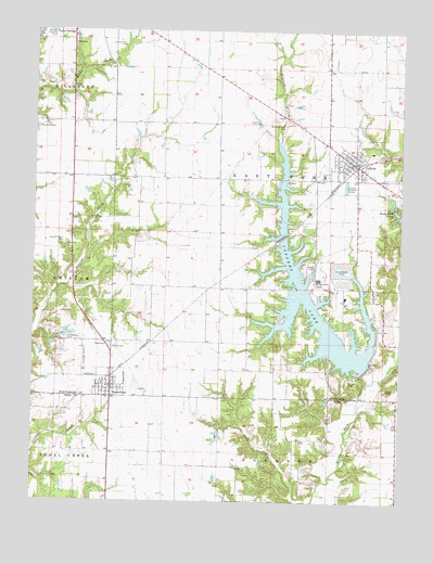
Coffeen, IL USGS Topographic Map
Click on map above to begin viewing in our Map Viewer.

This topographic map contains these locations and features:
Feature Name Type Latitude Longitude GNIS ID View Map
Bethel Church (historical)ChurchN39.1000°W89.3904°1772062View Map
City of CoffeenCivilN39.0882°W89.3898°2393583View Map
CoffeenPopulated PlaceN39.0892°W89.3906°406327View Map
Coffeen Elementary SchoolSchoolN39.0931°W89.3851°1821722View Map
Coffeen Free Methodist ChurchChurchN39.0892°W89.3937°1986070View Map
Coffeen LakeReservoirN39.0492°W89.4025°406328View Map
Coffeen Lake DamDamN39.0373°W89.3854°1691073View Map
Coffeen Lake State Fish and Wildlife AreaParkN39.0625°W89.4123°1821723View Map
Coffeen Methodist ChurchChurchN39.0909°W89.3931°1986071View Map
Coffeen Post OfficePost OfficeN39.0905°W89.3916°1986077View Map
Coffeen Power StationBuildingN39.0592°W89.4031°1821724View Map
Coffeen Volunteer Fire DepartmentBuildingN39.0913°W89.3928°2640799View Map
County Farm CemeteryCemeteryN39.1214°W89.4697°406662View Map
Donneilson CemeteryCemeteryN39.0434°W89.4887°407309View Map
DonnellsonPopulated PlaceN39.0278°W89.4734°407308View Map
Donnellson First Baptist ChurchChurchN39.0317°W89.4748°1986074View Map
Donnellson Post OfficePost OfficeN39.0296°W89.4731°2788407View Map
Edwards Chapel CemeteryCemeteryN39.0684°W89.4906°407799View Map
Elm Point (historical)Populated PlaceN39.0059°W89.4737°1785369View Map
Elm Point School (historical)SchoolN39.0056°W89.4734°1725158View Map
Holmes School (historical)SchoolN39.0862°W89.4662°1772093View Map
Hopewell School (historical)SchoolN39.0098°W89.4359°1725168View Map
Mansfield CemeteryCemeteryN39.0992°W89.4990°412907View Map
McDavid BranchStreamN39.0956°W89.4176°413245View Map
McDavid Point CemeteryCemeteryN39.1000°W89.4154°413246View Map
McDavid Point School (historical)SchoolN39.1009°W89.4126°1772108View Map
Montgomery County Farm (historical)LocaleN39.1223°W89.4718°1772114View Map
Muddy School (historical)SchoolN39.0142°W89.3754°1725182View Map
New Life Assembly of God ChurchChurchN39.0895°W89.3920°1986072View Map
Oak Grove School (historical)SchoolN39.0164°W89.4087°1725184View Map
Pocahontas School (historical)SchoolN39.0603°W89.3987°1772136View Map
Rocky Ford LakesReservoirN39.0766°W89.3759°416874View Map
Rocky Ford Sportsman Club North LakeReservoirN39.0797°W89.3779°1692209View Map
Rocky Ford Sportsman Club North Lake DamDamN39.0784°W89.3767°1692208View Map
Saint Johns Catholic ChurchChurchN39.0934°W89.3890°1986073View Map
Shoal Creek Fire Protection District Station 3BuildingN39.0303°W89.4737°2640731View Map
Township of East ForkCivilN39.1004°W89.4180°428932View Map
Traylor CemeteryCemeteryN39.0573°W89.4115°419824View Map
Village of DonnellsonCivilN39.0307°W89.4746°2398737View Map
Walnut Grove School (historical)SchoolN39.0487°W89.4265°1772163View Map

Note: Coordinates in the location and feature list above are referenced to NAD83 datum.


Copyright (C) 2008-2024 Ryan Niemi / Sunset Dynamics ... All Rights Reserved