TopoQuest Logo
Do you find TopoQuest useful?
Help keep TopoQuest running and adding new maps/features by donating!
Bitcoin:  19c7KJd3qBynnjoSw5npx9KScwjBe4ifkT
Litecoin:  LXs6TkuXGGXo1vDsWCkWVdjQX94eUKd6ui
Home View Maps Find Maps Find Places Resources & Links


Cobert Mesa South, New Mexico Topographic Map

USGS Map Title: Cobert Mesa South, NM
USGS Map MRC: 36103H5
DRG (GeoTIFF) Download: o36103h5.tif


Neighboring USGS Topographic Map Quads:


  Pine Canyon, CO  
37103A6
 

  Cobert Mesa North, CO  
37103A5
 

  Jesus Canyon, CO  
37103A4
 

  Cross L Ranch, NM  
36103H6
 

  Cobert Mesa South, NM  
36103H5
 

  Travesser Park, NM  
36103H4
 

  Cross L Ranch SW, NM  
36103G6
 

  Fiddler Springs, NM  
36103G5
 

  Guy, NM  
36103G4


Map MRC Location:

N37°
W104°
N37°
W103°
H8 H7 H6 H5 H4 H3 H2 H1
G8 G7 G6 G5 G4 G3 G2 G1
F8 F7 F6 F5 F4 F3 F2 F1
E8 E7 E6 E5 E4 E3 E2 E1
D8 D7 D6 D5 D4 D3 D2 D1
C8 C7 C6 C5 C4 C3 C2 C1
B8 B7 B6 B5 B4 B3 B2 B1
A8 A7 A6 A5 A4 A3 A2 A1
N36°
W104°
N36°
W103°

Cobert Mesa South, NM USGS 1:24K Topographic Map Preview:
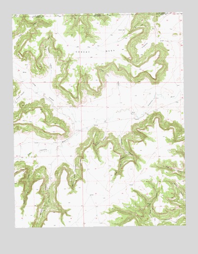
Cobert Mesa South, NM USGS Topographic Map
Click on map above to begin viewing in our Map Viewer.

This topographic map contains these locations and features:
Feature Name Type Latitude Longitude GNIS ID View Map
Boulder CanyonValleyN36.9309°W103.5563°886660View Map
Cedar CanyonValleyN36.9131°W103.6063°887320View Map
Christy CanyonValleyN36.9289°W103.5483°887573View Map
Cobert MesaSummitN36.9875°W103.5538°897341View Map
Core Log CanyonValleyN36.9186°W103.5441°887845View Map
Folsom AreaMineN36.9225°W103.5858°916600View Map
Gleason CanyonValleyN36.9117°W103.5980°889425View Map
Gleason SpringsSpringN36.9131°W103.5986°902690View Map
Horseshoe DrawValleyN36.9817°W103.5069°890193View Map
Indian Trail CanyonValleyN36.9556°W103.5483°890323View Map
Long CanyonValleyN36.9367°W103.5777°196278View Map
Milady CanyonValleyN36.9547°W103.6073°892037View Map
Sand Well CanyonValleyN36.8792°W103.5255°894538View Map
Thomas CanyonValleyN36.9606°W103.5988°895623View Map
White Rock CanyonValleyN36.9175°W103.5844°896522View Map
Wildcat CanyonValleyN36.8770°W103.5086°896601View Map

Note: Coordinates in the location and feature list above are referenced to NAD83 datum.


Copyright (C) 2008-2024 Ryan Niemi / Sunset Dynamics ... All Rights Reserved