TopoQuest Logo
Do you find TopoQuest useful?
Help keep TopoQuest running and adding new maps/features by donating!
Bitcoin:  19c7KJd3qBynnjoSw5npx9KScwjBe4ifkT
Litecoin:  LXs6TkuXGGXo1vDsWCkWVdjQX94eUKd6ui
Home View Maps Find Maps Find Places Resources & Links


Cobb Island, Virginia Topographic Map

USGS Map Title: Cobb Island, VA
USGS Map MRC: 37075C7
DRG (GeoTIFF) Download: o37075c7.tif


Neighboring USGS Topographic Map Quads:


  Franktown, VA  
37075D8
 

  Nassawadox, VA  
37075D7
 

  Quinby Inlet, VA  
37075D6
 

  Cheriton, VA  
37075C8
 

  Cobb Island, VA  
37075C7
 

  Great Machipongo Inlet, VA  
37075C6
 

  Townsend, VA  
37075B8
 

  Ship Shoal Inlet, VA  
37075B7


Map MRC Location:

N38°
W76°
N38°
W75°
H8 H7 H6 H5 H4 H3 H2 H1
G8 G7 G6 G5 G4 G3 G2 G1
F8 F7 F6 F5 F4 F3 F2 F1
E8 E7 E6 E5 E4 E3 E2 E1
D8 D7 D6 D5 D4 D3 D2 D1
C8 C7 C6 C5 C4 C3 C2 C1
B8 B7 B6 B5 B4 B3 B2 B1
A8 A7 A6 A5 A4 A3 A2 A1
N37°
W76°
N37°
W75°

Cobb Island, VA USGS 1:24K Topographic Map Preview:
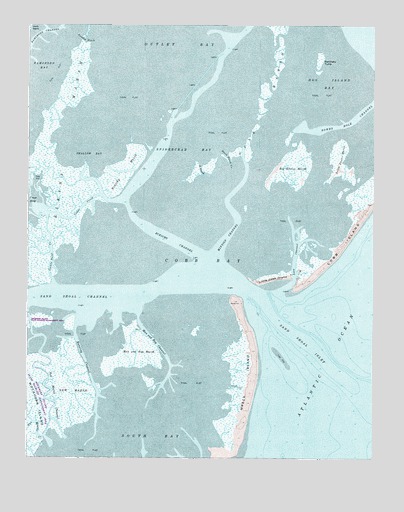
Cobb Island, VA USGS Topographic Map
Click on map above to begin viewing in our Map Viewer.

This topographic map contains these locations and features:
Feature Name Type Latitude Longitude GNIS ID View Map
Big Easter MarshSwampN37.3343°W75.7794°1463347View Map
Black Perch CreekChannelN37.3368°W75.8030°1463494View Map
Cedar CreekChannelN37.3221°W75.8552°1464592View Map
Cobb BayBayN37.3071°W75.8099°1465022View Map
Cockle Point CreekChannelN37.3099°W75.8663°1465041View Map
Eckichy ChannelChannelN37.3151°W75.8296°1466166View Map
Eckichy MarshSwampN37.3318°W75.8405°1466167View Map
Elkins MarshSwampN37.3301°W75.8666°1466236View Map
Gull MarshSwampN37.3551°W75.7888°1467595View Map
Little Cobb IslandIslandN37.3013°W75.7866°1477918View Map
Little Easter MarshSwampN37.3365°W75.7630°1469533View Map
Loon ChannelChannelN37.3085°W75.7783°1469854View Map
Man and Boy ChannelChannelN37.2826°W75.8277°1470037View Map
Man and Boy MarshSwampN37.2815°W75.8352°1470038View Map
Mittigy ChannelChannelN37.3246°W75.8024°1470645View Map
New MarshSwampN37.2704°W75.8585°1471468View Map
New Marsh ChannelChannelN37.2676°W75.8677°1471469View Map
Northeast ChannelChannelN37.3021°W75.7563°1477991View Map
Outlet BayBayN37.3693°W75.8180°1471979View Map
Parchaby TumpIslandN37.3646°W75.7694°1472053View Map
Rowes Hole ChannelChannelN37.3476°W75.7571°1473605View Map
Running ChannelChannelN37.2788°W75.8541°1473630View Map
Sand CreekChannelN37.3329°W75.8127°1473992View Map
Sand Shoal ChannelChannelN37.2960°W75.8552°1473996View Map
Sand Shoal InletBayN37.2860°W75.7791°1473997View Map
Shallow BayBayN37.3393°W75.8524°1474213View Map
Shell CreekStreamN37.2707°W75.8010°1474470View Map
South ChannelChannelN37.2771°W75.7810°1477990View Map
Southeast ChannelChannelN37.2815°W75.7624°1477989View Map
Spidercrab BayBayN37.3390°W75.8155°1474949View Map
Sunday DitchCanalN37.3707°W75.8541°1475327View Map
Two Mouths CreekStreamN37.2560°W75.8680°1476005View Map
Wreck IslandIslandN37.2732°W75.7946°1476997View Map

Note: Coordinates in the location and feature list above are referenced to NAD83 datum.


Copyright (C) 2008-2024 Ryan Niemi / Sunset Dynamics ... All Rights Reserved