TopoQuest Logo
Do you find TopoQuest useful?
Help keep TopoQuest running and adding new maps/features by donating!
Bitcoin:  19c7KJd3qBynnjoSw5npx9KScwjBe4ifkT
Litecoin:  LXs6TkuXGGXo1vDsWCkWVdjQX94eUKd6ui
Home View Maps Find Maps Find Places Resources & Links


Coats, North Carolina Topographic Map

USGS Map Title: Coats, NC
USGS Map MRC: 35078D6
DRG (GeoTIFF) Download: o35078d6.tif


Neighboring USGS Topographic Map Quads:


  Fuquay-Varina, NC  
35078E7
 

  Angier, NC  
35078E6
 

  Edmondson, NC  
35078E5
 

  Lillington, NC  
35078D7
 

  Coats, NC  
35078D6
 

  Benson, NC  
35078D5
 

  Bunnlevel, NC  
35078C7
 

  Erwin, NC  
35078C6
 

  Dunn, NC  
35078C5


Map MRC Location:

N36°
W79°
N36°
W78°
H8 H7 H6 H5 H4 H3 H2 H1
G8 G7 G6 G5 G4 G3 G2 G1
F8 F7 F6 F5 F4 F3 F2 F1
E8 E7 E6 E5 E4 E3 E2 E1
D8 D7 D6 D5 D4 D3 D2 D1
C8 C7 C6 C5 C4 C3 C2 C1
B8 B7 B6 B5 B4 B3 B2 B1
A8 A7 A6 A5 A4 A3 A2 A1
N35°
W79°
N35°
W78°

Coats, NC USGS 1:24K Topographic Map Preview:
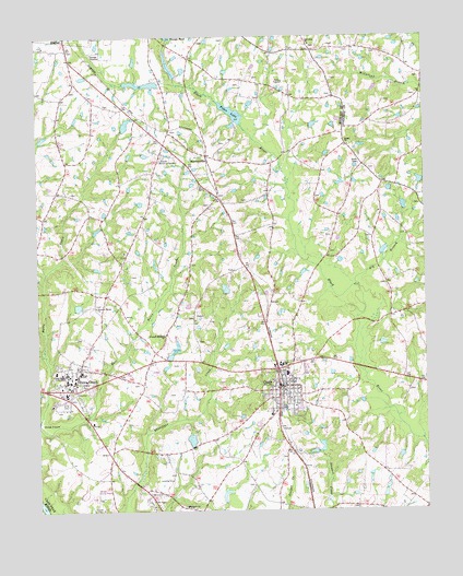
Coats, NC USGS Topographic Map
Click on map above to begin viewing in our Map Viewer.

This topographic map contains these locations and features:
Feature Name Type Latitude Longitude GNIS ID View Map
Bakers PondReservoirN35.3802°W78.6893°998891View Map
Bakers Pond DamDamN35.3768°W78.6897°1000691View Map
BarclaysvillePopulated PlaceN35.4688°W78.6942°980544View Map
Barclaysville FieldAirportN35.4684°W78.6873°2679112View Map
Bethel ChurchChurchN35.4715°W78.6486°981136View Map
Big BranchStreamN35.4343°W78.6461°981339View Map
Buies CreekPopulated PlaceN35.4132°W78.7356°982191View Map
Buies Creek Census Designated PlaceCensusN35.4126°W78.7363°2402731View Map
Buies Creek Elementary SchoolSchoolN35.4118°W78.7361°1006654View Map
Buies Creek Post OfficePost OfficeN35.4103°W78.7367°2774249View Map
Buies Creek Rural Fire and RescueBuildingN35.4055°W78.7372°2639378View Map
C A G Farms AirportAirportN35.4685°W78.6504°2717069View Map
Campbell UniversitySchoolN35.4099°W78.7403°982564View Map
Chesterfield LakeReservoirN35.4770°W78.7208°999008View Map
Chesterfield Lake DamDamN35.4752°W78.7214°999007View Map
CoatsPopulated PlaceN35.4079°W78.6720°1019711View Map
Coats Elementary SchoolSchoolN35.4135°W78.6714°1006653View Map
Coats Grove Fire and Rescue DepartmentBuildingN35.4093°W78.6730°2638308View Map
Coats Police DepartmentBuildingN35.4080°W78.6719°2769565View Map
Coats Post OfficePost OfficeN35.4076°W78.6731°2774203View Map
Dushee Shaw Halfway HouseBuildingN35.3754°W78.6597°1965153View Map
East Buies CreekStreamN35.3977°W78.7492°1020077View Map
Gregorys LakeReservoirN35.3938°W78.7005°998921View Map
Gregorys Lake DamDamN35.3952°W78.7014°998920View Map
Guys PondReservoirN35.4877°W78.7152°999029View Map
Guys Pond DamDamN35.4868°W78.7097°999028View Map
Harnett County Emergency Medical Service Transport Ambulance and Quick Response - Buies CreekBuildingN35.3987°W78.7317°2720311View Map
Harnett Regional JetportAirportN35.3796°W78.7343°2679168View Map
Lakeside Memorial GardensCemeteryN35.4690°W78.7089°988093View Map
Norman Urquhart GristmillBuildingN35.4102°W78.7292°1965327View Map
Plainview ChurchChurchN35.4979°W78.6611°992446View Map
Pleasant Memory ChurchChurchN35.4216°W78.7089°992554View Map
Pleasant Plains ChurchChurchN35.4290°W78.7303°992560View Map
Popes LakeLakeN35.4800°W78.6863°992675View Map
Popes Lake DamDamN35.4802°W78.6864°999009View Map
Prospect ChurchChurchN35.3766°W78.7020°992846View Map
Stewart Airport (historical)AirportN35.3835°W78.7067°997917View Map
Town of CoatsCivilN35.4069°W78.6685°2406287View Map
Township of Black RiverCivilN35.4940°W78.7484°1026763View Map
Township of GroveCivilN35.4061°W78.6593°1026766View Map
WCCE-FM (Buies Creek)TowerN35.4102°W78.7389°1018270View Map

Note: Coordinates in the location and feature list above are referenced to NAD83 datum.


Copyright (C) 2008-2024 Ryan Niemi / Sunset Dynamics ... All Rights Reserved