TopoQuest Logo
Do you find TopoQuest useful?
Help keep TopoQuest running and adding new maps/features by donating!
Bitcoin:  19c7KJd3qBynnjoSw5npx9KScwjBe4ifkT
Litecoin:  LXs6TkuXGGXo1vDsWCkWVdjQX94eUKd6ui
Home View Maps Find Maps Find Places Resources & Links


Coahoma, Texas Topographic Map

USGS Map Title: Coahoma, TX
USGS Map MRC: 32101C3
DRG (GeoTIFF) Download: o32101c3.tif


Neighboring USGS Topographic Map Quads:


  Luther, TX  
32101D4
 

  Big Spring North NE, TX  
32101D3
 

  Vincent, TX  
32101D2
 

  Big Spring North, TX  
32101C4
 

  Coahoma, TX  
32101C3
 

  Iatan, TX  
32101C2
 

  Big Spring South, TX  
32101B4
 

  Moss Creek Lake, TX  
32101B3
 

  Hyman, TX  
32101B2


Map MRC Location:

N33°
W102°
N33°
W101°
H8 H7 H6 H5 H4 H3 H2 H1
G8 G7 G6 G5 G4 G3 G2 G1
F8 F7 F6 F5 F4 F3 F2 F1
E8 E7 E6 E5 E4 E3 E2 E1
D8 D7 D6 D5 D4 D3 D2 D1
C8 C7 C6 C5 C4 C3 C2 C1
B8 B7 B6 B5 B4 B3 B2 B1
A8 A7 A6 A5 A4 A3 A2 A1
N32°
W102°
N32°
W101°

Coahoma, TX USGS 1:24K Topographic Map Preview:
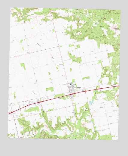
Coahoma, TX USGS Topographic Map
Click on map above to begin viewing in our Map Viewer.

This topographic map contains these locations and features:
Feature Name Type Latitude Longitude GNIS ID View Map
Allen LakeReservoirN32.2856°W101.2823°1861724View Map
Allen Lake DamDamN32.2851°W101.2837°1861723View Map
CoahomaPopulated PlaceN32.2965°W101.3062°1333021View Map
Coahoma City HallBuildingN32.2999°W101.3023°2753640View Map
Coahoma DivisionCivilN32.3417°W101.2573°1938632View Map
Coahoma DrawValleyN32.3222°W101.2751°1333022View Map
Coahoma High SchoolSchoolN32.3028°W101.3056°2006321View Map
Coahoma Post OfficePost OfficeN32.2949°W101.3061°2731951View Map
Guthrie DrawValleyN32.2555°W101.2936°1337144View Map
Howard County Constable's Office Precinct 2BuildingN32.2964°W101.3060°2750564View Map
Howard County Volunteer Fire Department CoahomaBuildingN32.2974°W101.3064°2551246View Map
Howard County Volunteer Fire Department Sand SpringsBuildingN32.2827°W101.3515°2551054View Map
MidwayPopulated PlaceN32.2746°W101.3704°1341555View Map
Moss CreekStreamN32.2523°W101.2910°1341968View Map
Salem ChurchChurchN32.3321°W101.3532°1346169View Map
Sand SpringsPopulated PlaceN32.2826°W101.3510°1346542View Map
Sand Springs Census Designated PlaceCensusN32.2795°W101.3495°2586984View Map
Sandy HollowValleyN32.2570°W101.3241°1346598View Map
Town of CoahomaCivilN32.2957°W101.3088°2413218View Map
Wildhorse MountainSummitN32.3571°W101.2562°1350084View Map

Note: Coordinates in the location and feature list above are referenced to NAD83 datum.


Copyright (C) 2008-2024 Ryan Niemi / Sunset Dynamics ... All Rights Reserved