TopoQuest Logo
Do you find TopoQuest useful?
Help keep TopoQuest running and adding new maps/features by donating!
Bitcoin:  19c7KJd3qBynnjoSw5npx9KScwjBe4ifkT
Litecoin:  LXs6TkuXGGXo1vDsWCkWVdjQX94eUKd6ui
Home View Maps Find Maps Find Places Resources & Links


Anahuac, Texas Topographic Map

USGS Map Title: Anahuac, TX
USGS Map MRC: 29094G6
DRG (GeoTIFF) Download: o29094g6.tif


Neighboring USGS Topographic Map Quads:


  Moss Bluff, TX  
29094H7
 

  Shiloh, TX  
29094H6
 

  Whites Bayou, TX  
29094H5
 

  Cove, TX  
29094G7
 

  Anahuac, TX  
29094G6
 

  Monroe City, TX  
29094G5
 

  Umbrella Point, TX  
29094F7
 

  Oak Island, TX  
29094F6
 

  Oyster Bayou, TX  
29094F5


Map MRC Location:

N30°
W95°
N30°
W94°
H8 H7 H6 H5 H4 H3 H2 H1
G8 G7 G6 G5 G4 G3 G2 G1
F8 F7 F6 F5 F4 F3 F2 F1
E8 E7 E6 E5 E4 E3 E2 E1
D8 D7 D6 D5 D4 D3 D2 D1
C8 C7 C6 C5 C4 C3 C2 C1
B8 B7 B6 B5 B4 B3 B2 B1
A8 A7 A6 A5 A4 A3 A2 A1
N29°
W95°
N29°
W94°

Anahuac, TX USGS 1:24K Topographic Map Preview:
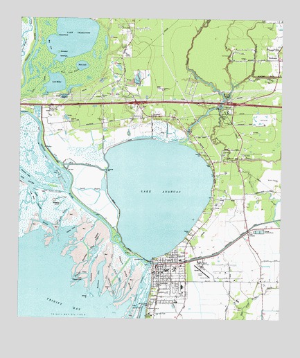
Anahuac, TX USGS Topographic Map
Click on map above to begin viewing in our Map Viewer.

This topographic map contains these locations and features:
Feature Name Type Latitude Longitude GNIS ID View Map
AnahuacPopulated PlaceN29.7730°W94.6827°1329510View Map
Anahuac CemeteryCemeteryN29.7863°W94.6674°1329511View Map
Anahuac Post OfficePost OfficeN29.7693°W94.6830°2731081View Map
Anahuac Volunteer Emergency Medical ServicesBuildingN29.7732°W94.6814°2720852View Map
Anahuac Volunteer Fire DepartmentBuildingN29.7732°W94.6814°2334441View Map
Barge BayouChannelN29.7855°W94.6952°1377725View Map
Barnes CemeteryCemeteryN29.8383°W94.6908°1330054View Map
Barrow CemeteryCemeteryN29.8744°W94.6333°1330096View Map
Barrow SloughBayN29.8030°W94.6344°1330099View Map
Baxter CemeteryCemeteryN29.8147°W94.6583°1330157View Map
Bayshore CemeteryCemeteryN29.8197°W94.6527°1330167View Map
Bayside Community HospitalHospitalN29.7517°W94.6863°1332633View Map
Benjamin Barrow CemeteryCemeteryN29.8086°W94.6269°1330418View Map
Big Hog BayouGutN29.8113°W94.7085°1330610View Map
Bird IslandIslandN29.8611°W94.7313°1372587View Map
Blind BayouGutN29.7766°W94.7238°1330867View Map
Bright Light ChurchChurchN29.8172°W94.6508°1331271View Map
Brown CemeteryCemeteryN29.8719°W94.6302°1331336View Map
Browns PassChannelN29.7683°W94.6963°1331375View Map
Buckeye IslandIslandN29.7983°W94.7302°1331504View Map
Bulkhead CoveBayN29.7613°W94.7113°1331587View Map
Buzzard RoostCapeN29.8677°W94.7319°1331775View Map
Chambers County AirportAirportN29.7712°W94.6616°1386152View Map
Chambers County Constable's Office Precinct 2BuildingN29.7701°W94.6852°2751533View Map
Chambers County Constable's Office Precinct 5BuildingN29.8482°W94.7037°2751530View Map
Chambers County JailBuildingN29.7701°W94.6851°2738747View Map
Chambers County Sheriff's OfficeBuildingN29.7700°W94.6852°2375935View Map
Chambersea HouseBuildingN29.7708°W94.6846°2031394View Map
CIG 816 HeliportAirportN29.8611°W94.7008°1384839View Map
City of AnahuacCivilN29.7649°W94.6787°2409705View Map
City of Anahuac Municipal BuildingBuildingN29.7732°W94.6820°2753344View Map
Cow Island BayouStreamN29.8724°W94.6624°1372142View Map
Davis SchoolSchoolN29.8577°W94.6369°1334100View Map
EminencePopulated PlaceN29.8338°W94.6913°1335440View Map
Eminence CemeteryCemeteryN29.8388°W94.6969°1335441View Map
Eminence ChurchChurchN29.8424°W94.6952°1335442View Map
Fort AnahuacLocaleN29.7561°W94.6888°2032121View Map
Fort Anahuac ParkParkN29.7563°W94.6855°1336047View Map
Garden BayouBayN29.7927°W94.7285°1336387View Map
Godfrey CemeteryCemeteryN29.8327°W94.7099°1336633View Map
HankamerPopulated PlaceN29.8583°W94.6269°1337306View Map
Hankamer Post OfficePost OfficeN29.8593°W94.6267°2731533View Map
Hankamer Volunteer Fire DepartmentBuildingN29.8612°W94.6275°2334580View Map
Jacks CoveBayN29.7861°W94.7278°2573023View Map
Jacks PassChannelN29.7861°W94.7163°1338567View Map
John Wiggins BayouGutN29.8691°W94.7474°1374303View Map
Kings PassChannelN29.7680°W94.7024°1339145View Map
Lake AnahuacLakeN29.8026°W94.6843°1372292View Map
Lake CharlotteLakeN29.8681°W94.7256°1373063View Map
Lake MillerLakeN29.8479°W94.7337°1341673View Map
Lake PassChannelN29.8480°W94.7399°1374447View Map
Lee GullyValleyN29.8472°W94.6489°1374498View Map
Lighthouse PassChannelN29.7630°W94.7052°1377722View Map
Little Hog BayouGutN29.8186°W94.7171°1340116View Map
Little Triangle PassChannelN29.7663°W94.7202°1340203View Map
Long Island BayouChannelN29.7958°W94.7396°1340476View Map
Middleton Memorial ChurchChurchN29.8377°W94.7324°1341541View Map
Mud LakeLakeN29.8554°W94.7210°1342203View Map
Mud Lake BayouGutN29.8516°W94.7274°1342210View Map
Old Fort AnahuacLocaleN29.7563°W94.6874°1343148View Map
Old RiverStreamN29.8022°W94.7263°1375278View Map
Old River CutoffChannelN29.8033°W94.7330°1343211View Map
Old River PassChannelN29.7741°W94.7049°1343214View Map
Peterson LakeLakeN29.8107°W94.7478°1343909View Map
Saint Mary ChurchChurchN29.8502°W94.6294°1346017View Map
Sand PointCapeN29.8588°W94.7271°1346530View Map
Smith BayouReservoirN29.8041°W94.7161°1347249View Map
Southwest PassChannelN29.7738°W94.7141°1347604View Map
Spring BranchStreamN29.8524°W94.6399°1376252View Map
Sunlight ChurchChurchN29.8588°W94.6424°1348069View Map
Tom Richardson CemeteryCemeteryN29.8599°W94.6496°1348628View Map
Triangle PassChannelN29.7683°W94.7208°1388182View Map
Turtle Bay Oil FieldOilfieldN29.8322°W94.6791°1348922View Map
Turtle Bay PassChannelN29.7924°W94.6974°1377724View Map
Turtle BayouStreamN29.8238°W94.6735°1376537View Map
Turtle BayouPopulated PlaceN29.8272°W94.6674°2034881View Map
WallisvillePopulated PlaceN29.8355°W94.7419°1379227View Map
Wallisville CemeteryCemeteryN29.8324°W94.7255°1349410View Map
Wallisville Heritage Park MuseumBuildingN29.8649°W94.6913°2014270View Map
Wallisville LakeReservoirN29.8081°W94.7303°1377736View Map
Wallisville Post OfficePost OfficeN29.8383°W94.7358°2731836View Map
Wallisville SchoolSchoolN29.8483°W94.7027°1349411View Map
Wes CoveBayN29.8638°W94.7352°1349654View Map
Whites BayouStreamN29.8386°W94.6546°1376769View Map
Wiggins CemeteryCemeteryN29.8336°W94.6966°1350044View Map

Note: Coordinates in the location and feature list above are referenced to NAD83 datum.


Copyright (C) 2008-2024 Ryan Niemi / Sunset Dynamics ... All Rights Reserved