TopoQuest Logo
Do you find TopoQuest useful?
Help keep TopoQuest running and adding new maps/features by donating!
Bitcoin:  19c7KJd3qBynnjoSw5npx9KScwjBe4ifkT
Litecoin:  LXs6TkuXGGXo1vDsWCkWVdjQX94eUKd6ui
Home View Maps Find Maps Find Places Resources & Links


Clifton Hill, Missouri Topographic Map

USGS Map Title: Clifton Hill, MO
USGS Map MRC: 39092D6
DRG (GeoTIFF) Download: o39092d6.tif


Neighboring USGS Topographic Map Quads:


  Bynumville, MO  
39092E7
 

  Prairie Hill, MO  
39092E6
 

  College Mound, MO  
39092E5
 

  Salisbury, MO  
39092D7
 

  Clifton Hill, MO  
39092D6
 

  Huntsville, MO  
39092D5
 

  Forest Green, MO  
39092C7
 

  Armstrong, MO  
39092C6
 

  Higbee, MO  
39092C5


Map MRC Location:

N40°
W93°
N40°
W92°
H8 H7 H6 H5 H4 H3 H2 H1
G8 G7 G6 G5 G4 G3 G2 G1
F8 F7 F6 F5 F4 F3 F2 F1
E8 E7 E6 E5 E4 E3 E2 E1
D8 D7 D6 D5 D4 D3 D2 D1
C8 C7 C6 C5 C4 C3 C2 C1
B8 B7 B6 B5 B4 B3 B2 B1
A8 A7 A6 A5 A4 A3 A2 A1
N39°
W93°
N39°
W92°

Clifton Hill, MO USGS 1:24K Topographic Map Preview:
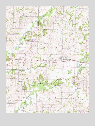
Clifton Hill, MO USGS Topographic Map
Click on map above to begin viewing in our Map Viewer.

This topographic map contains these locations and features:
Feature Name Type Latitude Longitude GNIS ID View Map
Big LakeReservoirN39.4603°W92.7102°761119View Map
Brown LakeReservoirN39.3964°W92.6542°762225View Map
Brown Lake DamDamN39.3967°W92.6535°762224View Map
City of Clifton HillCivilN39.4386°W92.6637°2393564View Map
Clifton HillPopulated PlaceN39.4381°W92.6663°729295View Map
Clifton Hill Post OfficePost OfficeN39.4423°W92.6656°2782795View Map
Dan Shepherd DamDamN39.4600°W92.7102°761118View Map
Dark CreekStreamN39.4398°W92.6302°716667View Map
Finnell CemeteryCemeteryN39.4400°W92.7230°717925View Map
Gross CemeteryCemeteryN39.4147°W92.7171°718895View Map
J P Ryals LakeReservoirN39.4600°W92.6285°761398View Map
J P Ryals Lake DamDamN39.4600°W92.6285°761397View Map
Johnson CemeteryCemeteryN39.4728°W92.6843°720361View Map
Kitchen CemeteryCemeteryN39.4156°W92.7110°720656View Map
KRES-FM (Moberly)TowerN39.4598°W92.7021°759145View Map
Lee School (historical)SchoolN39.4111°W92.7302°734088View Map
Mount AiryPopulated PlaceN39.3770°W92.6349°729345View Map
Pleasant Wood ChurchChurchN39.4117°W92.7324°724654View Map
Quinn and Fitzgerald LakeReservoirN39.4000°W92.6802°761862View Map
Quinn and Fitzgerald Lake DamDamN39.4000°W92.6802°761861View Map
Richardson CemeteryCemeteryN39.4595°W92.7191°725260View Map
Silver CreekStreamN39.3814°W92.7235°726447View Map
Smith School (historical)SchoolN39.3753°W92.6260°726627View Map
Sweet Spring CreekStreamN39.4139°W92.6563°727381View Map
Township of CliftonCivilN39.4597°W92.6599°767258View Map
Vaughn School (historical)SchoolN39.3923°W92.6671°728158View Map
Washington School (historical)SchoolN39.4745°W92.7396°734087View Map
Westran Middle SchoolSchoolN39.4415°W92.6646°2571157View Map

Note: Coordinates in the location and feature list above are referenced to NAD83 datum.


Copyright (C) 2008-2024 Ryan Niemi / Sunset Dynamics ... All Rights Reserved