TopoQuest Logo
Do you find TopoQuest useful?
Help keep TopoQuest running and adding new maps/features by donating!
Bitcoin:  19c7KJd3qBynnjoSw5npx9KScwjBe4ifkT
Litecoin:  LXs6TkuXGGXo1vDsWCkWVdjQX94eUKd6ui
Home View Maps Find Maps Find Places Resources & Links


Clear Lake, Indiana Topographic Map

USGS Map Title: Clear Lake, IN
USGS Map MRC: 41084F7
DRG (GeoTIFF) Download: o41084f7.tif


Neighboring USGS Topographic Map Quads:


  California, MI  
41084G8
 

  Camden, MI  
41084G7
 

  Reading, MI  
41084G6
 

  Angola East, IN  
41084F8
 

  Clear Lake, IN  
41084F7
 

  Nettle Lake, OH  
41084F6
 

  Hamilton, IN  
41084E8
 

  Edon, OH  
41084E7
 

  Blakeslee, OH  
41084E6


Map MRC Location:

N42°
W85°
N42°
W84°
H8 H7 H6 H5 H4 H3 H2 H1
G8 G7 G6 G5 G4 G3 G2 G1
F8 F7 F6 F5 F4 F3 F2 F1
E8 E7 E6 E5 E4 E3 E2 E1
D8 D7 D6 D5 D4 D3 D2 D1
C8 C7 C6 C5 C4 C3 C2 C1
B8 B7 B6 B5 B4 B3 B2 B1
A8 A7 A6 A5 A4 A3 A2 A1
N41°
W85°
N41°
W84°

Clear Lake, IN USGS 1:24K Topographic Map Preview:
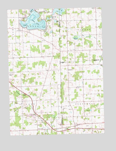
Clear Lake, IN USGS Topographic Map
Click on map above to begin viewing in our Map Viewer.

This topographic map contains these locations and features:
Feature Name Type Latitude Longitude GNIS ID View Map
Barnes SwampSwampN41.6674°W84.8634°430508View Map
BillingstownPopulated PlaceN41.6931°W84.7955°1048524View Map
Billingstown CemeteryCemeteryN41.6896°W84.7972°1806075View Map
Clear LakeLakeN41.7370°W84.8398°432625View Map
Clear LakePopulated PlaceN41.7375°W84.8333°432626View Map
Clear Lake ChurchChurchN41.7464°W84.8188°432627View Map
Clear Lake Police DepartmentBuildingN41.7298°W84.8547°2758131View Map
Clear Lake Post Office (historical)Post OfficeN41.7375°W84.8333°2027057View Map
ColumbiaPopulated PlaceN41.6331°W84.7886°1048617View Map
Columbia CemeteryCemeteryN41.6292°W84.7880°1039271View Map
Courtney CornerPopulated PlaceN41.6295°W84.8386°433047View Map
Dygert CemeteryCemeteryN41.6867°W84.8738°433828View Map
Eastpoint TerminalPopulated PlaceN41.6653°W84.8530°446774View Map
Handy LakeLakeN41.7374°W84.8112°435670View Map
Hanselman BranchStreamN41.6498°W84.8450°435700View Map
Lake AnneLakeN41.7400°W84.8213°430183View Map
Latter Day Saints ChurchChurchN41.7289°W84.8572°437644View Map
Long LakeLakeN41.7473°W84.8066°438270View Map
Marsh LakeLakeN41.7197°W84.7848°631618View Map
Mill Stream DrainStreamN41.6928°W84.7533°632346View Map
Mill Stream DrainCanalN41.6959°W84.7536°1065866View Map
Mirror LakeLakeN41.7417°W84.8169°439282View Map
Mud LakeLakeN41.6482°W84.7676°1043697View Map
Mud Lake Bog Nature PreserveParkN41.6481°W84.7680°1806085View Map
Murphy AirportAirportN41.6948°W84.8655°2717330View Map
PagePopulated PlaceN41.6876°W84.8597°446716View Map
Paradise PointCapeN41.7339°W84.8483°440861View Map
Powers ChurchChurchN41.6348°W84.8383°441525View Map
Rogers CemeteryCemeteryN41.6496°W84.7921°1045155View Map
Round LakeLakeN41.7488°W84.8423°442353View Map
Saint Paul ChurchChurchN41.7478°W84.8263°442760View Map
School Number 2 (historical)SchoolN41.6667°W84.7955°1080891View Map
South Camden Post Office (historical)Post OfficeN41.7083°W84.7578°2418297View Map
Stallman BridgeBridgeN41.6448°W84.8411°444056View Map
Teeters CemeteryCemeteryN41.7187°W84.8258°444623View Map
Town of Clear LakeCivilN41.7382°W84.8392°2396653View Map
Township of Clear LakeCivilN41.7312°W84.8329°453223View Map
Township of YorkCivilN41.6591°W84.8418°454070View Map
West Branch Fish CreekStreamN41.6253°W84.8227°445721View Map
Westgate TerminalLocaleN41.6298°W84.7975°1055275View Map
YorkPopulated PlaceN41.6884°W84.8225°449750View Map

Note: Coordinates in the location and feature list above are referenced to NAD83 datum.


Copyright (C) 2008-2024 Ryan Niemi / Sunset Dynamics ... All Rights Reserved