TopoQuest Logo
Do you find TopoQuest useful?
Help keep TopoQuest running and adding new maps/features by donating!
Bitcoin:  19c7KJd3qBynnjoSw5npx9KScwjBe4ifkT
Litecoin:  LXs6TkuXGGXo1vDsWCkWVdjQX94eUKd6ui
Home View Maps Find Maps Find Places Resources & Links


Claybrook, Tennessee Topographic Map

USGS Map Title: Claybrook, TN
USGS Map MRC: 35088F6
DRG (GeoTIFF) Download: o35088f6.tif


Neighboring USGS Topographic Map Quads:


  Medina, TN  
35088G7
 

  Spring Creek, TN  
35088G6
 

  Cedar Grove, TN  
35088G5
 

  Jackson North, TN  
35088F7
 

  Claybrook, TN  
35088F6
 

  Juno, TN  
35088F5
 

  Jackson South, TN  
35088E7
 

  Beech Bluff, TN  
35088E6
 

  Luray, TN  
35088E5


Map MRC Location:

N36°
W89°
N36°
W88°
H8 H7 H6 H5 H4 H3 H2 H1
G8 G7 G6 G5 G4 G3 G2 G1
F8 F7 F6 F5 F4 F3 F2 F1
E8 E7 E6 E5 E4 E3 E2 E1
D8 D7 D6 D5 D4 D3 D2 D1
C8 C7 C6 C5 C4 C3 C2 C1
B8 B7 B6 B5 B4 B3 B2 B1
A8 A7 A6 A5 A4 A3 A2 A1
N35°
W89°
N35°
W88°

Claybrook, TN USGS 1:24K Topographic Map Preview:
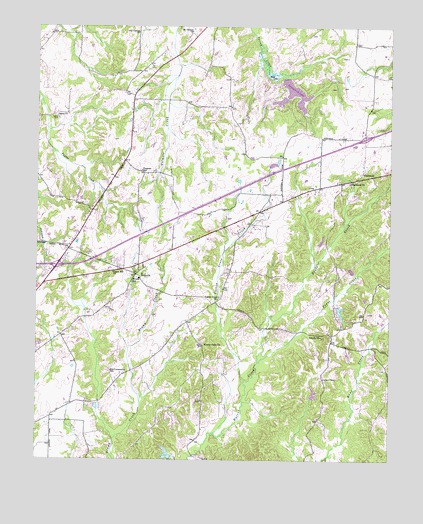
Claybrook, TN USGS Topographic Map
Click on map above to begin viewing in our Map Viewer.

This topographic map contains these locations and features:
Feature Name Type Latitude Longitude GNIS ID View Map
Blair LakeLakeN35.7358°W88.6670°1277649View Map
Blair LakeReservoirN35.7359°W88.6669°1302108View Map
Brown ChurchChurchN35.6784°W88.7126°1305444View Map
Brown SchoolSchoolN35.6776°W88.7134°1305457View Map
Center Point ChurchChurchN35.6584°W88.6901°1280140View Map
ClaybrookPopulated PlaceN35.7084°W88.6342°1305947View Map
Claybrook ChurchChurchN35.7048°W88.6392°1280633View Map
Commissioner District 10CivilN35.7406°W88.7152°2464317View Map
Cotton GrovePopulated PlaceN35.6706°W88.6862°1312104View Map
Cotton Grove ChurchChurchN35.6720°W88.6848°1306127View Map
Cotton Grove CreekStreamN35.6478°W88.6762°1281358View Map
Duncan LakeReservoirN35.6267°W88.7036°1301980View Map
Duncan Lake DamDamN35.6251°W88.7017°1301981View Map
Fern LakeReservoirN35.7274°W88.6567°1302092View Map
Fern Lake DamDamN35.7284°W88.6567°1302093View Map
Interchange 87CrossingN35.6809°W88.7428°1312110View Map
Interchange 93CrossingN35.7181°W88.6342°1312111View Map
Jones CreekStreamN35.6534°W88.6712°1289785View Map
Liberty ChurchChurchN35.6609°W88.6492°1291127View Map
Madison County Fire Department Station 12BuildingN35.6770°W88.7135°2654022View Map
Mount Carmel ChurchChurchN35.7481°W88.6951°1294584View Map
OFDBA Dam Number 86-95-2DamN35.7467°W88.6717°1302109View Map
Old Carmel ChurchChurchN35.7478°W88.7139°1296286View Map
Progress SchoolSchoolN35.7081°W88.7131°1298567View Map
Salem CemeteryCemeteryN35.7228°W88.7428°1300540View Map
Salem ChurchChurchN35.7242°W88.7431°1300553View Map
Spring Creek-Beech Bluff Division (historical)CensusN35.6981°W88.7076°1648858View Map
Springbrook LakeReservoirN35.7319°W88.6594°1302097View Map
Springbrook Lake DamDamN35.7334°W88.6617°1302103View Map
Sunset LakeReservoirN35.7290°W88.6629°1302102View Map
Sunset Lake DamDamN35.7301°W88.6601°1302096View Map
Trace CreekStreamN35.6531°W88.6712°1272817View Map
Tri-Community SchoolSchoolN35.6506°W88.7234°1304163View Map
Union Hill ChurchChurchN35.6790°W88.7226°1304253View Map
WBBJ-TV (Jackson)TowerN35.6376°W88.6923°1640151View Map

Note: Coordinates in the location and feature list above are referenced to NAD83 datum.


Copyright (C) 2008-2024 Ryan Niemi / Sunset Dynamics ... All Rights Reserved