TopoQuest Logo
Do you find TopoQuest useful?
Help keep TopoQuest running and adding new maps/features by donating!
Bitcoin:  19c7KJd3qBynnjoSw5npx9KScwjBe4ifkT
Litecoin:  LXs6TkuXGGXo1vDsWCkWVdjQX94eUKd6ui
Home View Maps Find Maps Find Places Resources & Links


Clarksville, Texas Topographic Map

USGS Map Title: Clarksville, TX
USGS Map MRC: 33095E1
DRG (GeoTIFF) Download: o33095e1.tif


Neighboring USGS Topographic Map Quads:


  Bagwell, TX  
33095F2
 

  Dimple, TX  
33095F1
 

  White Rock, TX  
33094F8
 

  Line Branch, TX  
33095E2
 

  Clarksville, TX  
33095E1
 

  Annona, TX  
33094E8
 

  Bogata, TX  
33095D2
 

  Cuthand, TX  
33095D1
 

  Boxelder, TX  
33094D8


Map MRC Location:

N34°
W96°
N34°
W95°
H8 H7 H6 H5 H4 H3 H2 H1
G8 G7 G6 G5 G4 G3 G2 G1
F8 F7 F6 F5 F4 F3 F2 F1
E8 E7 E6 E5 E4 E3 E2 E1
D8 D7 D6 D5 D4 D3 D2 D1
C8 C7 C6 C5 C4 C3 C2 C1
B8 B7 B6 B5 B4 B3 B2 B1
A8 A7 A6 A5 A4 A3 A2 A1
N33°
W96°
N33°
W95°

Clarksville, TX USGS 1:24K Topographic Map Preview:
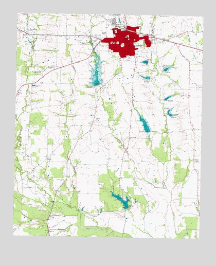
Clarksville, TX USGS Topographic Map
Click on map above to begin viewing in our Map Viewer.

This topographic map contains these locations and features:
Feature Name Type Latitude Longitude GNIS ID View Map
Aikin GrovePopulated PlaceN33.5557°W95.0486°1379325View Map
American Legion ParkParkN33.6093°W95.0330°2028889View Map
BatesvillePopulated PlaceN33.6084°W95.1119°2034754View Map
Boggy CreekStreamN33.5282°W95.0241°1352585View Map
Brewster CemeteryCemeteryN33.5654°W95.0719°1352860View Map
Bruton CreekStreamN33.5651°W95.1238°1353098View Map
Cheatham Middle SchoolSchoolN33.6171°W95.0594°2008004View Map
Cheatham SchoolSchoolN33.6162°W95.0594°1354335View Map
City of ClarksvilleCivilN33.6110°W95.0561°2409470View Map
Claphand CreekStreamN33.5165°W95.0872°1354544View Map
ClarksvillePopulated PlaceN33.6107°W95.0527°1354578View Map
Clarksville City HallBuildingN33.6099°W95.0554°2753180View Map
Clarksville DivisionCivilN33.6217°W95.0585°1938625View Map
Clarksville Elementary SchoolSchoolN33.6087°W95.0580°2008005View Map
Clarksville Fire and RescueBuildingN33.6126°W95.0523°2655156View Map
Clarksville High SchoolSchoolN33.6096°W95.0572°2008006View Map
Clarksville Police DepartmentBuildingN33.6100°W95.0554°2751235View Map
Clarksville Post OfficePost OfficeN33.6134°W95.0508°2731394View Map
Clarksville/Red River County-J D Trissell FieldAirportN33.5932°W95.0652°1384782View Map
Dam Number 10DamN33.5776°W95.0249°1355566View Map
Dam Number 11DamN33.5596°W95.0363°1384549View Map
Dam Number 12DamN33.5857°W95.0708°1355568View Map
Dam Number 13DamN33.5984°W95.0369°1355570View Map
Dam Number 14DamN33.5698°W95.0227°1355573View Map
Dam Number 7DamN33.5943°W95.0258°1355604View Map
Dam Number 8DamN33.5898°W95.0358°1355606View Map
Delaware CreekStreamN33.6076°W95.0402°1355885View Map
East Texas Medical CenterHospitalN33.6116°W95.0993°2015748View Map
Fairgrounds CemeteryCemeteryN33.6121°W95.0719°1357167View Map
Fairview CemeteryCemeteryN33.6084°W95.0727°1357176View Map
First Presbyterian ChurchChurchN33.6107°W95.0522°2023698View Map
Harris Chapel CemeteryCemeteryN33.5982°W95.0766°1358846View Map
Hebron CemeteryCemeteryN33.6237°W95.0341°1358986View Map
KCAR-AM (Clarksville)TowerN33.6115°W95.0172°1385527View Map
KCBZ-FM (Clarksville)TowerN33.6132°W95.0177°1385810View Map
Langford Club LakeReservoirN33.6240°W95.0424°1967710View Map
Lifenet Emergency Medical ServiceBuildingN33.6069°W95.0730°2720917View Map
Lynch CreekStreamN33.5415°W95.0252°1361996View Map
MabryPopulated PlaceN33.6134°W95.1183°1380120View Map
McCoy CreekStreamN33.5362°W95.1205°1362395View Map
McKenzie CemeteryCemeteryN33.5943°W95.1036°1362487View Map
McKenzie College Historical MonumentParkN33.5923°W95.1077°1384614View Map
New Century StadiumParkN33.6018°W95.0505°1384628View Map
New Shamrock CemeteryCemeteryN33.6151°W95.1169°1363779View Map
Peters PrairiePopulated PlaceN33.5432°W95.0049°1380344View Map
Pleasant Hill CemeteryCemeteryN33.5318°W95.0922°1365427View Map
Red River Country Club DamDamN33.5168°W95.0486°1860357View Map
Red River CountyCivilN33.6207°W95.0504°1383979View Map
Red River County Constable's Office Precinct 1BuildingN33.6133°W95.0513°2751274View Map
Red River County CourthouseBuildingN33.6132°W95.0513°2030574View Map
Red River County Law Enforcement CenterBuildingN33.6140°W95.0521°2738659View Map
Red River County Sheriff's OfficeBuildingN33.6140°W95.0522°2751125View Map
Scatter CreekStreamN33.5054°W95.0799°1367821View Map
SherryPopulated PlaceN33.5434°W95.1030°1380531View Map
Smathers-Demorse HouseBuildingN33.6129°W95.0497°2032616View Map
Soil Conservation Service Site 1 DamDamN33.6218°W95.0419°1860339View Map
Soil Conservation Service Site 10 DamDamN33.5774°W95.0245°1860347View Map
Soil Conservation Service Site 10 ReservoirReservoirN33.5785°W95.0239°1860348View Map
Soil Conservation Service Site 11 DamDamN33.5595°W95.0354°1860349View Map
Soil Conservation Service Site 11 ReservoirReservoirN33.5607°W95.0365°1860350View Map
Soil Conservation Service Site 12 DamDamN33.5856°W95.0698°1860351View Map
Soil Conservation Service Site 12 ReservoirReservoirN33.5851°W95.0702°1860352View Map
Soil Conservation Service Site 13 DamDamN33.5973°W95.0373°1860353View Map
Soil Conservation Service Site 13 ReservoirReservoirN33.5987°W95.0383°1860354View Map
Soil Conservation Service Site 14 DamDamN33.5687°W95.0217°1860355View Map
Soil Conservation Service Site 14 ReservoirReservoirN33.5698°W95.0217°1860356View Map
Soil Conservation Service Site 7 DamDamN33.5938°W95.0255°1860343View Map
Soil Conservation Service Site 7 ReservoirReservoirN33.5948°W95.0247°1860344View Map
Soil Conservation Service Site 8 DamDamN33.5896°W95.0354°1860345View Map
Soil Conservation Service Site 8 ReservoirReservoirN33.5897°W95.0369°1860346View Map
South LakeReservoirN33.5209°W95.0526°1368705View Map
Temple Baptist ChurchChurchN33.6132°W95.0455°2023697View Map

Note: Coordinates in the location and feature list above are referenced to NAD83 datum.


Copyright (C) 2008-2024 Ryan Niemi / Sunset Dynamics ... All Rights Reserved