TopoQuest Logo
Do you find TopoQuest useful?
Help keep TopoQuest running and adding new maps/features by donating!
Bitcoin:  19c7KJd3qBynnjoSw5npx9KScwjBe4ifkT
Litecoin:  LXs6TkuXGGXo1vDsWCkWVdjQX94eUKd6ui
Home View Maps Find Maps Find Places Resources & Links


Clarkridge, Arkansas Topographic Map

USGS Map Title: Clarkridge, AR
USGS Map MRC: 36092D3
DRG (GeoTIFF) Download: o36092d3.tif


Neighboring USGS Topographic Map Quads:


  Gainesville, MO  
36092E4
 

  Udall, MO  
36092E3
 

  Bakersfield, MO  
36092E2
 

  Midway, AR  
36092D4
 

  Clarkridge, AR  
36092D3
 

  Gamaliel, AR  
36092D2
 

  Mountain Home West, AR  
36092C4
 

  Mountain Home East, AR  
36092C3
 

  Norfork Dam North, AR  
36092C2


Map MRC Location:

N37°
W93°
N37°
W92°
H8 H7 H6 H5 H4 H3 H2 H1
G8 G7 G6 G5 G4 G3 G2 G1
F8 F7 F6 F5 F4 F3 F2 F1
E8 E7 E6 E5 E4 E3 E2 E1
D8 D7 D6 D5 D4 D3 D2 D1
C8 C7 C6 C5 C4 C3 C2 C1
B8 B7 B6 B5 B4 B3 B2 B1
A8 A7 A6 A5 A4 A3 A2 A1
N36°
W93°
N36°
W92°

Clarkridge, AR USGS 1:24K Topographic Map Preview:
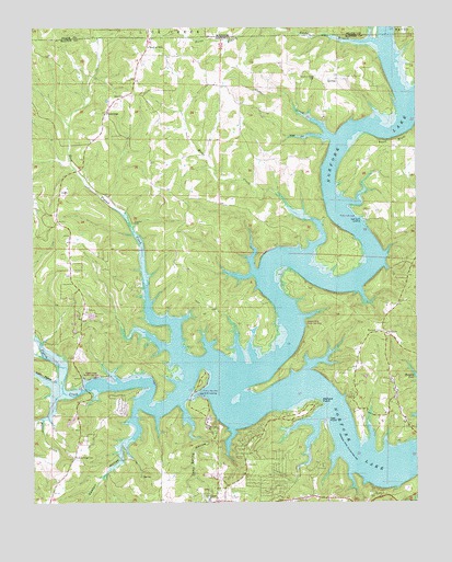
Clarkridge, AR USGS Topographic Map
Click on map above to begin viewing in our Map Viewer.

This topographic map contains these locations and features:
Feature Name Type Latitude Longitude GNIS ID View Map
101 Gamaliel Volunteer Fire Protection DistrictBuildingN36.4265°W92.2576°2116054View Map
Bean BluffCliffN36.4706°W92.2574°46187View Map
Bentley Ridge CemeteryCemeteryN36.4873°W92.2827°46393View Map
Biems Ford (historical)CrossingN36.4798°W92.2535°69344View Map
Briar CreekStreamN36.4398°W92.2865°46930View Map
Camp Spring HollowValleyN36.4009°W92.3268°47335View Map
Cedar CreekStreamN36.4712°W92.2768°47585View Map
Church of ChristChurchN36.4948°W92.3374°69351View Map
ClarkridgePopulated PlaceN36.4778°W92.3513°76623View Map
Clarkridge Post OfficePost OfficeN36.4781°W92.3502°84490View Map
Clarkridge Volunteer Fire Department Station 1BuildingN36.4346°W92.3625°2116275View Map
Clarkridge Volunteer Fire Department Station 2 Primary StationBuildingN36.4816°W92.3456°2116276View Map
Clarkridge Volunteer Fire Department Station 3BuildingN36.4906°W92.3030°2116277View Map
Cranfield LandingLocaleN36.4031°W92.3207°57601View Map
Cranfield Use AreaParkN36.4048°W92.3210°69360View Map
Dogwood ParkPopulated PlaceN36.3790°W92.3002°69364View Map
East Pigeon CreekStreamN36.4338°W92.3380°48772View Map
Fawn ParkPopulated PlaceN36.3917°W92.3579°69368View Map
Fords BranchStreamN36.4964°W92.2708°76946View Map
Goodall HollowValleyN36.4001°W92.3418°49495View Map
Granfiled Ferry (historical)CrossingN36.4073°W92.3107°69378View Map
Kingswood EstatesPopulated PlaceN36.3917°W92.3271°69392View Map
Lakeside TerracePopulated PlaceN36.3898°W92.3063°69394View Map
Little Pigeon CreekStreamN36.4053°W92.3657°51308View Map
Mallard PointPopulated PlaceN36.3981°W92.2888°69397View Map
Mallard PointCapeN36.4023°W92.2815°51627View Map
Maynard CemeteryCemeteryN36.4203°W92.2613°77621View Map
One Hundred One ChurchChurchN36.4195°W92.2599°53050View Map
Pigeon CreekStreamN36.4015°W92.3640°53361View Map
Pigeon Creek Public Use AreaParkN36.4084°W92.3546°69425View Map
Quality Ridge CemeteryCemeteryN36.3876°W92.3621°78121View Map
Quality Ridge School (historical)SchoolN36.3837°W92.3643°69428View Map
Red Bank LandingLocaleN36.4495°W92.2677°58471View Map
Red Bank Use AreaParkN36.4503°W92.2690°69430View Map
Rose HollowValleyN36.4715°W92.2793°54206View Map
Seward Point Public Use AreaParkN36.4223°W92.2860°69436View Map
Teal PointCapeN36.3970°W92.2788°55481View Map
Thacker CemeteryCemeteryN36.4487°W92.3424°55500View Map
Township of PigeonCivilN36.4510°W92.3490°69568View Map
Walker CreekStreamN36.4040°W92.3654°55963View Map
Zion ChurchChurchN36.4823°W92.3460°56634View Map

Note: Coordinates in the location and feature list above are referenced to NAD83 datum.


Copyright (C) 2008-2024 Ryan Niemi / Sunset Dynamics ... All Rights Reserved