TopoQuest Logo
Do you find TopoQuest useful?
Help keep TopoQuest running and adding new maps/features by donating!
Bitcoin:  19c7KJd3qBynnjoSw5npx9KScwjBe4ifkT
Litecoin:  LXs6TkuXGGXo1vDsWCkWVdjQX94eUKd6ui
Home View Maps Find Maps Find Places Resources & Links


Chrome, California Topographic Map

USGS Map Title: Chrome, CA
USGS Map MRC: 39122F5
DRG (GeoTIFF) Download: o39122f5.tif


Neighboring USGS Topographic Map Quads:


  Hall Ridge, CA  
39122G6
 

  Newville, CA  
39122G5
 

  Sehorn Creek, CA  
39122G4
 

  Alder Springs, CA  
39122F6
 

  Chrome, CA  
39122F5
 

  Julian Rocks, CA  
39122F4
 

  Felkner Hill, CA  
39122E6
 

  Elk Creek, CA  
39122E5
 

  Fruto, CA  
39122E4


Map MRC Location:

N40°
W123°
N40°
W122°
H8 H7 H6 H5 H4 H3 H2 H1
G8 G7 G6 G5 G4 G3 G2 G1
F8 F7 F6 F5 F4 F3 F2 F1
E8 E7 E6 E5 E4 E3 E2 E1
D8 D7 D6 D5 D4 D3 D2 D1
C8 C7 C6 C5 C4 C3 C2 C1
B8 B7 B6 B5 B4 B3 B2 B1
A8 A7 A6 A5 A4 A3 A2 A1
N39°
W123°
N39°
W122°

Chrome, CA USGS 1:24K Topographic Map Preview:
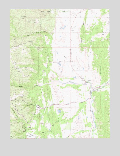
Chrome, CA USGS Topographic Map
Click on map above to begin viewing in our Map Viewer.

This topographic map contains these locations and features:
Feature Name Type Latitude Longitude GNIS ID View Map
Bald HillSummitN39.7243°W122.5831°266405View Map
Black Diamond MineMineN39.7379°W122.6028°266458View Map
ChromePopulated PlaceN39.7290°W122.5494°1656302View Map
Dry Lake ReservoirReservoirN39.6895°W122.6131°266662View Map
East ReservoirReservoirN39.6928°W122.6151°266683View Map
Gillaspy RanchLocaleN39.6552°W122.5894°266747View Map
Gray Eagle MineMineN39.7374°W122.5933°266770View Map
Grindstone CemeteryCemeteryN39.6807°W122.5341°266779View Map
Grindstone CreekStreamN39.6707°W122.5247°266780View Map
Grindstone Indian RancheriaCivilN39.6720°W122.5179°266781View Map
Hamilton 374 DamDamN39.6932°W122.5578°1663845View Map
James E Drew 373 DamDamN39.6515°W122.5594°1663844View Map
Millsap Chrome CemeteryCemeteryN39.7499°W122.5353°267017View Map
Powder HouseLocaleN39.6654°W122.6125°267142View Map
Rattlesnake CreekStreamN39.6438°W122.6147°267162View Map
Red MountainSummitN39.7427°W122.6097°267168View Map
Rocky RidgeRidgeN39.7299°W122.5347°267191View Map
Rowcroft RanchLocaleN39.6277°W122.6028°267197View Map
Salt CreekStreamN39.6318°W122.5225°234613View Map
Watson CreekStreamN39.6796°W122.5294°237346View Map
Watson GraveCemeteryN39.6907°W122.5847°268813View Map

Note: Coordinates in the location and feature list above are referenced to NAD83 datum.


Copyright (C) 2008-2024 Ryan Niemi / Sunset Dynamics ... All Rights Reserved