TopoQuest Logo
Do you find TopoQuest useful?
Help keep TopoQuest running and adding new maps/features by donating!
Bitcoin:  19c7KJd3qBynnjoSw5npx9KScwjBe4ifkT
Litecoin:  LXs6TkuXGGXo1vDsWCkWVdjQX94eUKd6ui
Home View Maps Find Maps Find Places Resources & Links


Chesterfield, South Carolina Topographic Map

USGS Map Title: Chesterfield, SC
USGS Map MRC: 34080F1
DRG (GeoTIFF) Download: o34080f1.tif


Neighboring USGS Topographic Map Quads:


  Mount Croghan, SC  
34080G2
 

  Morven West, NC  
34080G1
 

  Morven East, NC  
34079G8
 

  Ruby, SC  
34080F2
 

  Chesterfield, SC  
34080F1
 

  Cheraw, SC  
34079F8
 

  Middendorf, SC  
34080E2
 

  Patrick, SC  
34080E1
 

  Cash, SC  
34079E8


Map MRC Location:

N35°
W81°
N35°
W80°
H8 H7 H6 H5 H4 H3 H2 H1
G8 G7 G6 G5 G4 G3 G2 G1
F8 F7 F6 F5 F4 F3 F2 F1
E8 E7 E6 E5 E4 E3 E2 E1
D8 D7 D6 D5 D4 D3 D2 D1
C8 C7 C6 C5 C4 C3 C2 C1
B8 B7 B6 B5 B4 B3 B2 B1
A8 A7 A6 A5 A4 A3 A2 A1
N34°
W81°
N34°
W80°

Chesterfield, SC USGS 1:24K Topographic Map Preview:
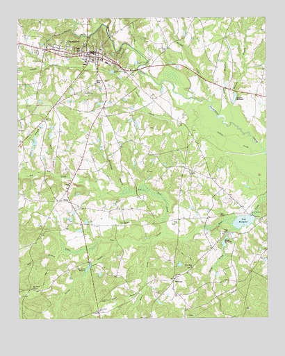
Chesterfield, SC USGS Topographic Map
Click on map above to begin viewing in our Map Viewer.

This topographic map contains these locations and features:
Feature Name Type Latitude Longitude GNIS ID View Map
Abrams CreekStreamN34.7154°W80.0284°1220124View Map
Bay BranchStreamN34.6535°W80.1003°1244987View Map
Bay Branch ChurchChurchN34.6379°W80.1178°1244988View Map
Bethel School (historical)SchoolN34.6874°W80.0409°1235589View Map
BethesdaPopulated PlaceN34.6413°W80.0476°1220587View Map
Bethesda CemeteryCemeteryN34.6423°W80.0466°1248727View Map
Bethesda ChurchChurchN34.6424°W80.0459°1246815View Map
Bethesda School (historical)SchoolN34.6438°W80.0409°1235590View Map
Bethesda School (historical)SchoolN34.6404°W80.0481°1235591View Map
Big Bear CreekStreamN34.6607°W80.0503°1246866View Map
Catoe (historical)Populated PlaceN34.7396°W80.1203°1235611View Map
ChesterfieldPopulated PlaceN34.7360°W80.0881°1231164View Map
Chesterfield City CemeteryCemeteryN34.7337°W80.0907°1248729View Map
Chesterfield DivisionCivilN34.7242°W80.1005°1938228View Map
Chesterfield Fire DepartmentBuildingN34.7350°W80.0901°2578298View Map
Chesterfield High SchoolSchoolN34.7377°W80.0940°1235627View Map
Chesterfield Middle SchoolSchoolN34.7315°W80.0798°1235628View Map
Chesterfield Police DepartmentBuildingN34.7362°W80.0860°2734246View Map
Chesterfield Rescue SquadBuildingN34.7346°W80.0895°2739572View Map
Cow BranchStreamN34.6865°W80.1151°1221788View Map
Craigs Mill (historical)LocaleN34.7429°W80.0909°1235637View Map
Cross BranchStreamN34.6402°W80.0615°1221847View Map
Cross Branch CemeteryCemeteryN34.6327°W80.0835°1221848View Map
Cross Branch ChurchChurchN34.6285°W80.0848°1221849View Map
Drucilla ChurchChurchN34.6857°W80.0376°1247560View Map
Drucilla School (historical)SchoolN34.6865°W80.0376°1235640View Map
Edwards SchoolSchoolN34.7235°W80.0840°1247644View Map
Evans Mill (historical)LocaleN34.7029°W80.0387°1235646View Map
Fannie CemeteryCemeteryN34.6351°W80.0540°1245723View Map
Fords Mill (historical)LocaleN34.7140°W80.0167°1235661View Map
Hunts MillPopulated PlaceN34.6610°W80.0209°1231411View Map
Hunts MillpondReservoirN34.6554°W80.0210°1246104View Map
Hunts Spring (historical)Populated PlaceN34.6602°W80.0115°1235679View Map
Hurst Pond Dam D-3204DamN34.6985°W80.1165°1239985View Map
Indian CreekStreamN34.6946°W80.0012°1223437View Map
Jimmies CreekStreamN34.7379°W80.0665°987611View Map
Little Bear CreekStreamN34.6607°W80.0503°1246382View Map
Lower Macedonia Baptist ChurchChurchN34.6685°W80.0084°1246478View Map
Mash BranchStreamN34.6857°W80.1073°1224360View Map
Merriman Mill (historical)LocaleN34.6488°W80.0887°1235712View Map
Merriman MillpondReservoirN34.6465°W80.0898°1224455View Map
Mount Mary Baptist ChurchChurchN34.6463°W80.0378°1249601View Map
Mount Olive School (historical)SchoolN34.7085°W80.1128°1235725View Map
Mount Prong CreekStreamN34.6568°W80.0584°1249668View Map
Oakland Baptist ChurchChurchN34.7082°W80.1109°1249927View Map
Oakland CemeteryCemeteryN34.7083°W80.1122°1248738View Map
Odom Mill (historical)LocaleN34.6479°W80.1198°1235731View Map
Peniel ChurchChurchN34.6649°W80.0448°1250058View Map
Pine Grove Baptist ChurchChurchN34.7377°W80.0501°1250111View Map
Pine Grove CemeteryCemeteryN34.7368°W80.0498°1248740View Map
Piney Grove School (historical)SchoolN34.7371°W80.0478°1235748View Map
Polson Mill (historical)LocaleN34.6502°W80.1137°1235755View Map
Pows Mill (historical)LocaleN34.7049°W80.0403°1235757View Map
Reedy BranchStreamN34.7132°W80.0176°1225806View Map
Rivers (historical)Populated PlaceN34.7152°W80.0565°1235760View Map
Rivers Chapel Baptist Church (historical)ChurchN34.7065°W80.0431°1235761View Map
Robeson BranchStreamN34.7063°W80.0176°1225913View Map
Robeson MillpondReservoirN34.7165°W80.0155°1225914View Map
Robeson Millpond Dam D-3207DamN34.7146°W80.0165°1239983View Map
Rocky ProngStreamN34.6535°W80.0226°1225985View Map
Saint James ChurchChurchN34.6649°W80.0720°1250523View Map
Saint James School (historical)SchoolN34.6643°W80.0562°1235767View Map
ShilohPopulated PlaceN34.6740°W80.0990°1227980View Map
Shiloh CemeteryCemeteryN34.6821°W80.0992°1248744View Map
Shiloh ChurchChurchN34.6818°W80.0992°1250875View Map
Shiloh School (historical)SchoolN34.6743°W80.1051°1235771View Map
South Carolina Noname 13001 D-3206 DamDamN34.6674°W80.0065°1237665View Map
Sowells Pond Dam D-3205DamN34.6618°W80.0931°1239984View Map
Spence School (historical)SchoolN34.7193°W80.0140°1235775View Map
Spencer Mill CreekStreamN34.6943°W80.0009°1250989View Map
Stewarts Mill (historical)LocaleN34.6863°W80.1101°1235780View Map
Strickland BranchStreamN34.6774°W80.0698°1226927View Map
Tavern BranchStreamN34.7443°W80.0970°1227042View Map
Teal Chapel Baptist ChurchChurchN34.6677°W80.0234°1251131View Map
Teal MillpondReservoirN34.6652°W80.0117°1251132View Map
Teals Mill (historical)LocaleN34.6668°W80.0053°1235785View Map
Teals Mill Rural Volunteer Fire DepartmentBuildingN34.6708°W80.0118°2578211View Map
Teals MillpondReservoirN34.6668°W80.0665°1237666View Map
Town of ChesterfieldCivilN34.7330°W80.0781°2406265View Map
Twitty ProngStreamN34.6568°W80.0756°1251241View Map

Note: Coordinates in the location and feature list above are referenced to NAD83 datum.


Copyright (C) 2008-2024 Ryan Niemi / Sunset Dynamics ... All Rights Reserved