TopoQuest Logo
Do you find TopoQuest useful?
Help keep TopoQuest running and adding new maps/features by donating!
Bitcoin:  19c7KJd3qBynnjoSw5npx9KScwjBe4ifkT
Litecoin:  LXs6TkuXGGXo1vDsWCkWVdjQX94eUKd6ui
Home View Maps Find Maps Find Places Resources & Links


Cherryvale, Kansas Topographic Map

USGS Map Title: Cherryvale, KS
USGS Map MRC: 37095C5
DRG (GeoTIFF) Download: o37095c5.tif


Neighboring USGS Topographic Map Quads:


  Neodesha, KS  
37095D6
 

  Morehead, KS  
37095D5
 

  Thayer, KS  
37095D4
 

  Sycamore, KS  
37095C6
 

  Cherryvale, KS  
37095C5
 

  Dennis, KS  
37095C4
 

  Independence, KS  
37095B6
 

  Liberty, KS  
37095B5
 

  Mound Valley, KS  
37095B4


Map MRC Location:

N38°
W96°
N38°
W95°
H8 H7 H6 H5 H4 H3 H2 H1
G8 G7 G6 G5 G4 G3 G2 G1
F8 F7 F6 F5 F4 F3 F2 F1
E8 E7 E6 E5 E4 E3 E2 E1
D8 D7 D6 D5 D4 D3 D2 D1
C8 C7 C6 C5 C4 C3 C2 C1
B8 B7 B6 B5 B4 B3 B2 B1
A8 A7 A6 A5 A4 A3 A2 A1
N37°
W96°
N37°
W95°

Cherryvale, KS USGS 1:24K Topographic Map Preview:
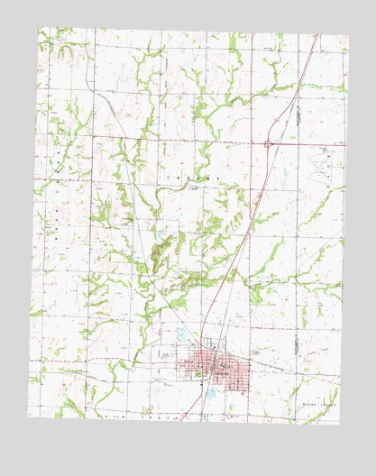
Cherryvale, KS USGS Topographic Map
Click on map above to begin viewing in our Map Viewer.

This topographic map contains these locations and features:
Feature Name Type Latitude Longitude GNIS ID View Map
Bible Holiness ChurchChurchN37.2665°W95.5598°2688828View Map
Cherry CreekStreamN37.2837°W95.5778°469808View Map
Cherry School (historical)SchoolN37.3023°W95.5383°483845View Map
CherryvalePopulated PlaceN37.2703°W95.5525°469813View Map
Cherryvale Assembly of God ChurchChurchN37.2681°W95.5490°2688845View Map
Cherryvale Christian ChurchChurchN37.2681°W95.5483°2688846View Map
Cherryvale City HallBuildingN37.2686°W95.5527°2693324View Map
Cherryvale City Lake DamDamN37.2584°W95.5536°480013View Map
Cherryvale Fire DepartmentBuildingN37.2686°W95.5533°2111191View Map
Cherryvale Middle / High SchoolSchoolN37.2632°W95.5470°481099View Map
Cherryvale MuseumBuildingN37.2672°W95.5496°2694299View Map
Cherryvale Police DepartmentBuildingN37.2686°W95.5527°2503895View Map
Cherryvale Post OfficePost OfficeN37.2701°W95.5523°2693664View Map
Cherryvale Public LibraryBuildingN37.2681°W95.5480°2694700View Map
Cherryvale United Methodist ChurchChurchN37.2697°W95.5542°2688847View Map
Cherryvale Wastewater PlantLocaleN37.2761°W95.5823°2691964View Map
Church of the NazareneChurchN37.2681°W95.5537°2688883View Map
City of CherryvaleCivilN37.2693°W95.5540°485553View Map
Corbin (historical)Populated PlaceN37.2520°W95.5544°484962View Map
Fairview CemeteryCemeteryN37.2727°W95.5342°469810View Map
First Baptist ChurchChurchN37.2687°W95.5480°2688960View Map
First Presbyterian ChurchChurchN37.2671°W95.5475°2689017View Map
First Southern Baptist ChurchChurchN37.2651°W95.5420°2689029View Map
Hanley School (historical)SchoolN37.2828°W95.6025°483855View Map
Hazel Dell ChurchChurchN37.3696°W95.5311°469804View Map
Hiltz CemeteryCemeteryN37.3550°W95.5940°469803View Map
Howard School (historical)SchoolN37.2531°W95.5850°483857View Map
Kansas Department of Transportation Montgomery County Rest AreaLocaleN37.3494°W95.5273°2692530View Map
Lincoln Central Elementary SchoolSchoolN37.2679°W95.5468°2437496View Map
Logan ParkParkN37.2656°W95.5580°469812View Map
McKinley Elementary SchoolSchoolN37.2692°W95.5600°469811View Map
Montgomery County Rural Fire District Station 4BuildingN37.2716°W95.5575°2111640View Map
New Life Praise and Worship ChurchChurchN37.2714°W95.5566°2689133View Map
Peoples School (historical)SchoolN37.3115°W95.6205°483864View Map
Pleasant Dale ChurchChurchN37.3134°W95.5850°469806View Map
Pleasant Dale SchoolSchoolN37.3115°W95.5844°469807View Map
Racob School (historical)SchoolN37.3401°W95.5480°483871View Map
Rock CreekStreamN37.3570°W95.5303°469814View Map
Saint Francis Xavier Catholic ChurchChurchN37.2676°W95.5559°2689169View Map
Saint Francis Xavier CemeteryCemeteryN37.2632°W95.5755°469809View Map
Saint Johns School (historical)SchoolN37.3059°W95.5011°483760View Map
Township of CherryCivilN37.3203°W95.5610°469816View Map
Tri-City AirportAirportN37.3374°W95.5088°469805View Map
Wetzel School (historical)SchoolN37.3465°W95.5755°483884View Map

Note: Coordinates in the location and feature list above are referenced to NAD83 datum.


Copyright (C) 2008-2024 Ryan Niemi / Sunset Dynamics ... All Rights Reserved