TopoQuest Logo
Do you find TopoQuest useful?
Help keep TopoQuest running and adding new maps/features by donating!
Bitcoin:  19c7KJd3qBynnjoSw5npx9KScwjBe4ifkT
Litecoin:  LXs6TkuXGGXo1vDsWCkWVdjQX94eUKd6ui
Home View Maps Find Maps Find Places Resources & Links


Cherokee South, Iowa Topographic Map

USGS Map Title: Cherokee South, IA
USGS Map MRC: 42095F5
DRG (GeoTIFF) Download: o42095f5.tif


Neighboring USGS Topographic Map Quads:


  Cleghorn, IA  
42095G6
 

  Cherokee North, IA  
42095G5
 

  Peterson SW, IA  
42095G4
 

  Quimby, IA  
42095F6
 

  Cherokee South, IA  
42095F5
 

  Aurelia, IA  
42095F4
 

  Washta, IA  
42095E6
 

  Quimby SE, IA  
42095E5
 

  Galva, IA  
42095E4


Map MRC Location:

N43°
W96°
N43°
W95°
H8 H7 H6 H5 H4 H3 H2 H1
G8 G7 G6 G5 G4 G3 G2 G1
F8 F7 F6 F5 F4 F3 F2 F1
E8 E7 E6 E5 E4 E3 E2 E1
D8 D7 D6 D5 D4 D3 D2 D1
C8 C7 C6 C5 C4 C3 C2 C1
B8 B7 B6 B5 B4 B3 B2 B1
A8 A7 A6 A5 A4 A3 A2 A1
N42°
W96°
N42°
W95°

Cherokee South, IA USGS 1:24K Topographic Map Preview:
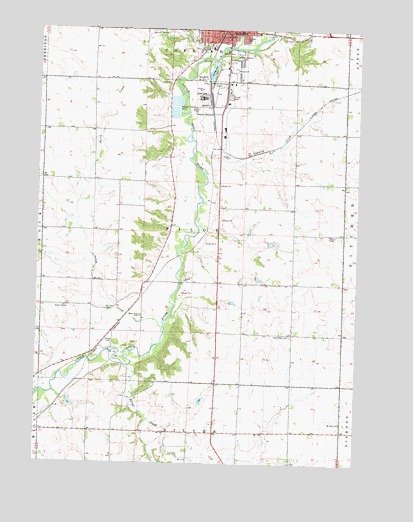
Cherokee South, IA USGS Topographic Map
Click on map above to begin viewing in our Map Viewer.

This topographic map contains these locations and features:
Feature Name Type Latitude Longitude GNIS ID View Map
American TheatreBuildingN42.7498°W95.5506°2730012View Map
Baptist ChurchChurchN42.6500°W95.5044°1907271View Map
CherokeeLocaleN42.7472°W95.5558°1907198View Map
CherokeePopulated PlaceN42.7494°W95.5517°455370View Map
Cherokee City HallBuildingN42.7486°W95.5522°463807View Map
Cherokee CountyCivilN42.7356°W95.6238°465207View Map
Cherokee County FairgroundLocaleN42.7383°W95.5489°1907203View Map
Cherokee County Regional AirportAirportN42.7337°W95.5539°466744View Map
Cherokee Fire DepartmentBuildingN42.7483°W95.5528°1907172View Map
Cherokee Public LibraryBuildingN42.7483°W95.5517°1907175View Map
Cherokee Wastewater Treatment PlantLocaleN42.7236°W95.5731°2728265View Map
Coonley CreekStreamN42.7139°W95.5650°455615View Map
Coonley Creek FarmsLocaleN42.7234°W95.5237°2730033View Map
De Leon Post Office (historical)Post OfficeN42.6333°W95.5642°1907160View Map
DeLeon (historical)LocaleN42.6472°W95.5403°466294View Map
First Farmers Co-op Company ElevatorLocaleN42.7455°W95.5592°1907171View Map
Gengler FarmsLocaleN42.6261°W95.5933°2730035View Map
Glassmaker FarmLocaleN42.7140°W95.5572°2730038View Map
Good Hope CemeteryCemeteryN42.6619°W95.5261°456955View Map
Harold Clark Habitat AreaParkN42.6500°W95.6225°1907153View Map
Hilltop Angus FarmLocaleN42.6335°W95.6120°2740232View Map
Iowa Osteopathic InstituteHospitalN42.7389°W95.5511°1907184View Map
Kennedy Chiropractic OfficeHospitalN42.7411°W95.5522°1907183View Map
Lincoln SchoolSchoolN42.7466°W95.5442°458393View Map
Loucks FarmLocaleN42.6305°W95.5643°2740234View Map
Mortenson Dairy FarmLocaleN42.6321°W95.5536°2730036View Map
Mount Oliver ChurchChurchN42.6372°W95.5061°459319View Map
Oak Hill CemeteryCemeteryN42.7496°W95.5771°459714View Map
Onawa JunctionPopulated PlaceN42.7250°W95.5578°464683View Map
Pearse AccessLocaleN42.6472°W95.6247°1907154View Map
Perry CreekStreamN42.6642°W95.5753°460091View Map
Pilot RockSummitN42.6958°W95.5531°1907211View Map
Pilot Rock LookoutLocaleN42.6958°W95.5531°1907210View Map
Pilot Rock Lookout Historical MarkerParkN42.6958°W95.5531°1907209View Map
Pilot Rock Post Office (historical)Post OfficeN42.6572°W95.5828°466476View Map
Railroad CreekStreamN42.7450°W95.5483°460504View Map
Redtail Ridge Habitat AreaParkN42.6694°W95.5753°1907151View Map
Reorganized Church of Jesus Christ of Latter Day SaintsChurchN42.7494°W95.5517°1907272View Map
Rhea FarmsLocaleN42.6727°W95.6243°2740236View Map
S and T FarmsLocaleN42.6698°W95.5042°2730053View Map
Saint Lukes Gordon Recovery CenterHospitalN42.7494°W95.5520°1907185View Map
Saint Pauls United Methodist ChurchChurchN42.7494°W95.5561°1907192View Map
Silver CreekStreamN42.6530°W95.5889°461619View Map
Silver Sioux Recreation AreaParkN42.6514°W95.5892°1907152View Map
Spring Lake ParkParkN42.7389°W95.5586°461905View Map
Township of PilotCivilN42.6917°W95.5645°468515View Map
Wescott ParkParkN42.7439°W95.5508°462797View Map
West Point CemeteryCemeteryN42.6675°W95.5845°462901View Map
Will FarmLocaleN42.7498°W95.5087°2730055View Map

Note: Coordinates in the location and feature list above are referenced to NAD83 datum.


Copyright (C) 2008-2024 Ryan Niemi / Sunset Dynamics ... All Rights Reserved